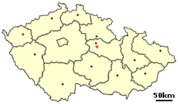
Honbice is sa mall village in the Pardubice Region of the Czech Republic. It has around 200 inhabitants.
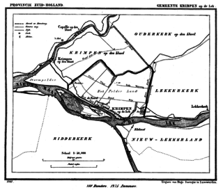
Krimpen aan de Lek is a town on the Lek River in the municipality of Krimpenerwaard, province of South Holland, the Netherlands. It had 6,607 inhabitants in 2008.
Wartowice is a village in the administrative district of Gmina Warta Bolesławiecka, within Bolesławiec County, Lower Silesian Voivodeship, in south-western Poland.

Pulczynów is a village in the administrative district of Gmina Frampol, within Biłgoraj County, Lublin Voivodeship, in eastern Poland. It lies approximately 8 kilometres (5 mi) south-east of Frampol, 12 km (7 mi) north of Biłgoraj, and 68 km (42 mi) south of the regional capital Lublin.
Gąsówka-Somachy is a village in the administrative district of Gmina Łapy, within Białystok County, Podlaskie Voivodeship, in north-eastern Poland.
Łozowe is a village in the administrative district of Gmina Narewka, within Hajnówka County, Podlaskie Voivodeship, in north-eastern Poland, close to the border with Belarus. It lies approximately 7 kilometres (4 mi) north of Narewka, 22 km (14 mi) north-east of Hajnówka, and 47 km (29 mi) south-east of the regional capital Białystok.
Kraszew is a village in the administrative district of Gmina Andrespol, within Łódź East County, Łódź Voivodeship, in central Poland. It lies approximately 2 kilometres (1 mi) south-east of Andrespol and 15 km (9 mi) south-east of the regional capital Łódź.
Leosin is a village in the administrative district of Gmina Koluszki, within Łódź East County, Łódź Voivodeship, in central Poland. It lies approximately 7 kilometres (4 mi) east of Koluszki and 30 km (19 mi) east of the regional capital Łódź.

Mehdibəyli is a village in the Khojali Rayon of Azerbaijan. Since the Nagorno-Karabakh war the village has been administered by the de facto Nagorno-Karabakh Republic as part of Askeran Province.
Wierzchy is a village in the administrative district of Gmina Zadzim, within Poddębice County, Łódź Voivodeship, in central Poland. It lies approximately 5 kilometres (3 mi) north-east of Zadzim, 11 km (7 mi) south-west of Poddębice, and 40 km (25 mi) west of the regional capital Łódź.
Wygnanka is a village in the administrative district of Gmina Mszczonów, within Żyrardów County, Masovian Voivodeship, in east-central Poland. It lies approximately 12 kilometres (7 mi) south-east of Mszczonów, 23 km (14 mi) south-east of Żyrardów, and 44 km (27 mi) south-west of Warsaw.
Leszczyc is a village in the administrative district of Gmina Wierzbinek, within Konin County, Greater Poland Voivodeship, in west-central Poland.
Krzycko Małe is a village in the administrative district of Gmina Święciechowa, within Leszno County, Greater Poland Voivodeship, in west-central Poland. It lies approximately 6 kilometres (4 mi) north-west of Święciechowa, 10 km (6 mi) north-west of Leszno, and 65 km (40 mi) south-west of the regional capital Poznań.
Żołędnica is a village in the administrative district of Gmina Rawicz, within Rawicz County, Greater Poland Voivodeship, in west-central Poland. It lies approximately 6 kilometres (4 mi) north-east of Rawicz and 83 km (52 mi) south of the regional capital Poznań.
Chmielniki is a village in the administrative district of Gmina Suchowola, within Sokółka County, Podlaskie Voivodeship, in north-eastern Poland. It lies approximately 9 kilometres (6 mi) north of Suchowola, 37 km (23 mi) north-west of Sokółka, and 60 km (37 mi) north of the regional capital Białystok.
Tapilkajmy is a village in the administrative district of Gmina Bartoszyce, within Bartoszyce County, Warmian-Masurian Voivodeship, in northern Poland, close to the border with the Kaliningrad Oblast of Russia. It lies approximately 11 kilometres (7 mi) north-west of Bartoszyce and 57 km (35 mi) north of the regional capital Olsztyn.
Vinařice is a village and municipality in Beroun District in the Central Bohemian Region of the Czech Republic.

Mendes District is a district of Relizane Province, Algeria.
Ambau is an unincorporated community in York County, Pennsylvania, United States. Ambau is situated in North Codorus Township near the village of Menges Mills.
Beverwaard is a neighborhood of Rotterdam, Netherlands.


