
Méhtelek is a village in Szabolcs-Szatmár-Bereg county, in the Northern Great Plain region of eastern Hungary.
Vega de Valcarce is a village and municipality located in the region of El Bierzo. According to a census (INE), the municipality has a population of 865 inhabitants. The mayoress is María Luisa González Santín. The village is at an altitude of 631 m (2070.21 ft), and the average rainfall is around 622.05mm (24.49 in). The village is along the route of the Camino de Santiago, which brings tourists in the spring and summer months. There are several accommodations for these tourists. The Valcarce River runs through the village, and there are various tourist attractions throughout the village and surrounding the village as well.
Norma is a village in the Tibet Autonomous Region of China.

Cienkowice is a village in the administrative district of Gmina Ciepłowody, within Ząbkowice Śląskie County, Lower Silesian Voivodeship, in south-western Poland.
Mānsān is a settlement in Shan State, Burma.
Suszcza is a village in the administrative district of Gmina Michałowo, within Białystok County, Podlaskie Voivodeship, in north-eastern Poland, close to the border with Belarus. It lies approximately 13 kilometres (8 mi) south of Michałowo and 40 km (25 mi) south-east of the regional capital Białystok.
Wojsławice is a village in the administrative district of Gmina Zduńska Wola, within Zduńska Wola County, Łódź Voivodeship, in central Poland. It lies approximately 8 kilometres (5 mi) north of Zduńska Wola and 39 km (24 mi) west of the regional capital Łódź.
Bratoszewice is a village in the administrative district of Gmina Stryków, within Zgierz County, Łódź Voivodeship, in central Poland. It lies approximately 6 kilometres (4 mi) north-east of Stryków, 20 km (12 mi) north-east of Zgierz, and 22 km (14 mi) north-east of the regional capital Łódź.
Kania Góra is a village in the administrative district of Gmina Zgierz, within Zgierz County, Łódź Voivodeship, in central Poland. It lies approximately 10 kilometres (6 mi) north of Zgierz and 19 km (12 mi) north of the regional capital Łódź.
Łańcuchów is a village in the administrative district of Gmina Milejów, within Łęczna County, Lublin Voivodeship, in eastern Poland. It lies approximately 6 kilometres (4 mi) south-east of Łęczna and 26 km (16 mi) east of the regional capital Lublin.
Sięciaszka Pierwsza is a village in the administrative district of Gmina Łuków, within Łuków County, Lublin Voivodeship, in eastern Poland. It lies approximately 5 kilometres (3 mi) west of Łuków and 79 km (49 mi) north of the regional capital Lublin.
Wilczyska is a village in the administrative district of Gmina Bobowa, within Gorlice County, Lesser Poland Voivodeship, in southern Poland. It lies approximately 4 kilometres (2 mi) south of Bobowa, 17 km (11 mi) west of Gorlice, and 84 km (52 mi) south-east of the regional capital Kraków.
Wojnarowa is a village in the administrative district of Gmina Korzenna, within Nowy Sącz County, Lesser Poland Voivodeship, in southern Poland. It lies approximately 7 kilometres (4 mi) east of Korzenna, 18 km (11 mi) east of Nowy Sącz, and 84 km (52 mi) south-east of the regional capital Kraków.
Perzyny is a village in the administrative district of Gmina Moskorzew, within Włoszczowa County, Wielkopolskie Voivodeship, in south-central Poland. It lies approximately 1 kilometre (1 mi) north-west of Moskorzew, 21 km (13 mi) south of Włoszczowa, and 54 km (34 mi) south-west of the regional capital Kielce.
Budy Wolskie is a village in the administrative district of Gmina Puszcza Mariańska, within Żyrardów County, Masovian Voivodeship, in east-central Poland. It lies approximately 6 kilometres (4 mi) south of Puszcza Mariańska, 14 km (9 mi) south of Żyrardów, and 54 km (34 mi) south-west of Warsaw.

Drzeczkowo is a village in the administrative district of Gmina Osieczna, within Leszno County, Greater Poland Voivodeship, in west-central Poland. It lies approximately 4 kilometres (2 mi) north of Osieczna, 12 km (7 mi) north-east of Leszno, and 55 km (34 mi) south of the regional capital Poznań.
Białcz is a village in the administrative district of Gmina Witnica, within Gorzów County, Lubusz Voivodeship, in western Poland. It lies approximately 4 kilometres (2 mi) south-east of Witnica and 23 km (14 mi) west of Gorzów Wielkopolski.
Borislavtsi is a village in the municipality of Madzharovo, in Haskovo Province, in southern Bulgaria.
Cirkveini is a village in Croatia.
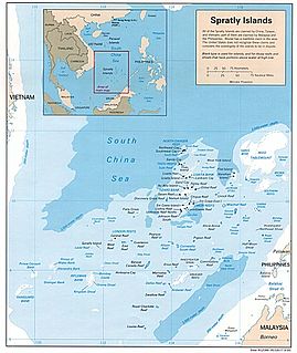
Bombay Castle(Vietnamese Bãi Ba Kè, Chinese : Pi-p'o pao chiao / Pengbo Bao) is a shoal with a lighthouse in the Rifleman Bank of the southern Spratly Islands. It is occupied by Vietnam.


