
Waychinicup National Park is in Western Australia, 404 kilometres (251 mi) southeast of Perth and 65 kilometres (40 mi) east of Albany, along the coast of the Southern Ocean.

Albany is a port city in the Great Southern region in the Australian state of Western Australia, 418 kilometres (260 mi) southeast of Perth, the state capital. The city centre is at the northern edge of Princess Royal Harbour, which is a part of King George Sound. The central business district is bounded by Mount Clarence to the east and Mount Melville to the west. The city is in the local government area of the City of Albany. While it is the oldest colonial, although not European, settlement in the territory that today is Western Australia, predating Perth and Fremantle by over two years, it was a semi-exclave of New South Wales for over four years until it was made part of the Swan River Colony.
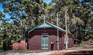
Torbay is a small town and a bay in the Great Southern region of Western Australia, 20 kilometres (12 mi) west of Albany. Torbay is within the City of Albany local government area. The Torbay townsite was gazetted in 1910.

King George Sound is a sound on the south coast of Western Australia. Named King George the Third's Sound in 1791, it was referred to as King George's Sound from 1805. The name "King George Sound" gradually came into use from about 1934, prompted by new Admiralty charts supporting the intention to eliminate the possessive 's' from geographical names.

Gilbert's potoroo or ngilkat is Australia's most endangered marsupial, the rarest marsupial in the world, and one of the world's rarest critically endangered mammals, found in south-western Western Australia. It is a small nocturnal macropod that lives in small groups.

The Breaksea Islands Group is a group of six islands, in the Southern Ocean, off the southwestern coast of Tasmania, Australia.
Kathleen Island is a steeply cliffed island that lies within Port Davey, an oceanic inlet, located in the south west region of Tasmania, Australia. The island has an area of approximately 11.35 hectares and is contained with the Southwest National Park, part of the Tasmanian Wilderness World Heritage Site and the Port Davey/Bathurst Harbour Marine Nature Reserve.

The City of Albany is a local government area in the Great Southern region of Western Australia, about 410 kilometres (255 mi) south-southeast of Perth, the capital of Western Australia. It covers an area of 4,312.3 square kilometres (1,665 sq mi), including the Greater Albany metropolitan area and the Port of Albany, as well as the surrounding agricultural district and some national parks. The City of Albany had a population of over 36,000 at the 2016 census.

Two Peoples Bay Nature Reserve is a protected area managed by the Department of Parks and Wildlife 35 kilometres (22 mi) east of Albany, Western Australia. The area is accessible by 2WD vehicles. The bay itself, including two small secluded beaches, faces due east and is protected from the Southern Ocean by a headland formed by the granite massif of Mount Gardner. The nature reserve was established in 1967 to protect the threatened noisy scrub-bird and its habitat. It is known for being the site of the discovery and naming of Gilbert's potoroo, but in 2015 a huge fire destroyed 90% of the tiny marsupial's habitat, as well as killing three-quarters of the remaining small population.

Breaksea Island in King George Sound in the Great Southern region of Western Australia is 12 kilometres (7 mi) south-east of Albany.
Bald Island is an island that is located in the Great Southern region of Western Australia. The island is 1.5 kilometres (1 mi) offshore from Cheynes Beach and is a protected area managed by the Department of Parks and Wildlife.

Green Island is an island in Oyster Harbour located approximately 6.5 kilometres (4 mi) northeast of Albany in Western Australia.

Seal Island in the Great Southern region of Western Australia is approximately 8.5 kilometres (5 mi) south-east of Albany and approximately 3 kilometres (2 mi) offshore from Frenchman Bay in King George Sound. It has a total area of 2.8 hectares. The island is designated as a nature reserve.
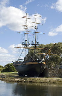
Amity was a 148-ton brig used in several notable voyages of exploration and settlement in Australia in the early nineteenth century.
Descriptive account of the panoramic view, &c. of King George's Sound, and the adjacent country is a pamphlet written by Robert Dale in 1834, containing description and commentary on the Panoramic View of King George's Sound, Part of the Colony of Swan River, a panorama of King George's Sound painted by Robert Havell. Together with prints of the Panorama, it was sold to attendees of an exhibition given in the home of Thomas Pettigrew. Dale was an ensign in the 63rd Regiment of Foot, which was posted to Western Australia in 1829. He was assigned to the Surveyor-General's department, and thus spent his four years in the colony exploring and surveying
Princess Royal Harbour is a part of King George Sound on the South coast of Western Australia, and harbour to Albany. On its northern shore is the Port of Albany. The name Princess Royal also appears in Albany in Princess Royal Fortress and Princess Royal Drive.

Middle Island is an island off the south coast of Western Australia in the Recherche Archipelago, around 120 km (75 mi) south-east of Esperance. It is known for its pink lake, Lake Hillier. Goose Island lies just adjacent to the north.

Breaksea Island Lighthouse is an active lighthouse located at Breaksea Island in King George Sound 12 kilometres (7.5 mi) from Albany.
The coastline of the Albany area was observed by Europeans for the first time in 1627 by the Dutchman François Thijssen, captain of the ship 't Gulden Zeepaert, who sailed to the east as far as Ceduna in South Australia and back. Captain Thijssen had discovered the south coast of Australia and charted about 1,768 kilometres (1,099 mi) of it between Cape Leeuwin and the Nuyts Archipelago.


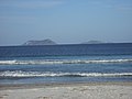 Michaelmas Island (left) and Breaksea Island (right) as viewed from Middleton Beach, Albany
 King George Sound as viewed from Mount Clarence, Albany
