Mid-German Crystalline High

Last updated
Structural map of central Europe, showing the positions of the Hercynian massifs and the zones in which the basement rocks can be divided. Gliederung der Varisziden in Mitteleuropa.jpg
Structural map of central Europe, showing the positions of the Hercynian massifs and the zones in which the basement rocks can be divided.

The Mid-German Crystalline High (or Mid-German High) is a structural high in the Paleozoic geology of Germany. The high forms a northeast-southwest oriented zone through Germany, but actual rock outcrops are sparse since Paleozoic basement rocks are in most of central Germany overlain by younger sedimentary rocks. The Mid-German Crystalline High crops out in the Odenwald, the Spessart, the northern Vosges and some small other massifs.

A high in structural geology and tectonics an area where tectonic uplift has taken place relative to its surroundings. Highs are often bounded by normal faults and can be regarded as the opposites of basins. A related word is a massif, an area where relative old rocks layers are found at the surface. A small high can be called a horst.

The PaleozoicEra is the earliest of three geologic eras of the Phanerozoic Eon. It is the longest of the Phanerozoic eras, lasting from 541 to 251.902 million years ago, and is subdivided into six geologic periods : the Cambrian, Ordovician, Silurian, Devonian, Carboniferous, and Permian. The Paleozoic comes after the Neoproterozoic Era of the Proterozoic Eon and is followed by the Mesozoic Era.

Germany Federal parliamentary republic in central-western Europe

Germany, officially the Federal Republic of Germany, is a country in Central and Western Europe, lying between the Baltic and North Seas to the north, and the Alps, Lake Constance and the High Rhine to the south. It borders Denmark to the north, Poland and the Czech Republic to the east, Austria and Switzerland to the south, France to the southwest, and Luxembourg, Belgium and the Netherlands to the west.

Contents

Structure

The Mid-German Crystalline High forms the northern part of the Saxothuringian Zone of the Hercynian orogeny. To the northwest it is bounded by the Northern Phyllite Zone (slightly metamorphosed sediments of mid-Paleozoic age), part of the Rhenohercynian Zone. Southeast of the Mid-German High lies a zone where early to mid-Paleozoic sediments of the Saxothuringian Basin crop out, metamorphosed during the Hercynian orogeny. Supposedly, during the mid-Paleozoic (Devonian and early Carboniferous) the Mid-German Crystalline High formed an area were not much deposition took place, perhaps an archipelago, between two marine or oceanic basins (the Rhenohercynian Basin to the north, the Saxothuringian Basin to the south). Some authors assume the northern basin's oceanic crust subducted beneath the Mid-German High. [1]

Saxothuringian Zone A structural or tectonic zone in the Hercynian or Variscan orogen of central and western Europe

The Saxothuringian Zone, Saxo-Thuringian zone or Saxothuringicum is in geology a structural or tectonic zone in the Hercynian or Variscan orogen of central and western Europe. Because rocks of Hercynian age are in most places covered by younger strata, the zone is not everywhere visible at the surface. Places where it crops out are the northern Bohemian Massif, the Spessart, the Odenwald, the northern parts of the Black Forest and Vosges and the southern part of the Taunus. West of the Vosges terranes on both sides of the English Channel are also seen as part of the zone, for example the Lizard complex in Cornwall or the Léon Zone of the Armorican Massif (Brittany).

Metamorphism The change of minerals in pre-existing rocks without melting into liquid magma

Metamorphism is the change of minerals or geologic texture in pre-existing rocks (protoliths), without the protolith melting into liquid magma. The change occurs primarily due to heat, pressure, and the introduction of chemically active fluids. The chemical components and crystal structures of the minerals making up the rock may change even though the rock remains a solid. Changes at or just beneath Earth's surface due to weathering or diagenesis are not classified as metamorphism. Metamorphism typically occurs between diagenesis, and melting (~850°C).

Rhenohercynian Zone A fold belt of west and central Europe, formed during the Hercynian orogeny

The Rhenohercynian Zone or Rheno-Hercynian zone in structural geology describes a fold belt of west and central Europe, formed during the Hercynian orogeny. The zone consists of folded and thrusted Devonian and early Carboniferous sedimentary rocks that were deposited in a back-arc basin along the southern margin of the then existing paleocontinent Laurussia.

Lithologies

The zone consists of Proterozoic orthogneisses and early Paleozoic volcanic (amphibolites with MORB-protoliths and tuffs) and sedimentary (pelites, calcareous schists and marbles) rocks that were metamorphosed at high grade during the Hercynian orogeny (up to amphibolite facies). These rocks were intruded by two generations of plutons: Silurian to Early Devonian (440-400 million years old) granitoids and middle Carboniferous (Hercynian, 340-325 million years old) granites. [2]

The Proterozoic is a geological eon spanning the time from the appearance of oxygen in Earth's atmosphere to just before the proliferation of complex life on the Earth. The name Proterozoic combines the two forms of ultimately Greek origin: protero- meaning "former, earlier", and -zoic, a suffix related to zoe "life". The Proterozoic Eon extended from 2500 mya to 541 mya, and is the most recent part of the Precambrian "supereon." The Proterozoic is the longest eon of the Earth's geologic time scale and it is subdivided into three geologic eras : the Paleoproterozoic, Mesoproterozoic, and Neoproterozoic.

Volcanic rock rocks composing or associated with volcanoes, volcanic activity or volcanism

Volcanic rock is a rock formed from magma erupted from a volcano. In other words, it differs from other igneous rock by being of volcanic origin. Like all rock types, the concept of volcanic rock is artificial, and in nature volcanic rocks grade into hypabyssal and metamorphic rocks and constitute an important element of some sediments and sedimentary rocks. For these reasons, in geology, volcanics and shallow hypabyssal rocks are not always treated as distinct. In the context of Precambrian shield geology, the term "volcanic" is often applied to what are strictly metavolcanic rocks. Volcanic rocks and sediment that form from magma erupted into the air are called "volcaniclastics," and these are technically sedimentary rocks.

Amphibolite A metamorphic rock containing mainly amphibole and plagioclase

Amphibolite is a metamorphic rock that contains amphibole, especially the species hornblende and actinolite, as well as plagioclase.

See also

Notes

  1. For example Ziegler (1990)
  2. Oncken (1997); Franke (2000)

Bibliography

Peter Ziegler Swiss geologist

Peter Alfred Ziegler was a Swiss geologist, who made contributions to the understanding of the geological evolution of Europe and the North Atlantic borderlands, of intraplate tectonics and of plate tectonic controls on the evolution and hydrocarbon potential of sedimentary basins. Ziegler's career consists of 33 years as exploration geologist with the petroleum industry, 30 of which with Shell, and 20 years of university teaching and research.

Royal Dutch Shell Anglo-Dutch oil company

Royal Dutch Shell plc, commonly known as Shell, is a British-Dutch oil and gas company headquartered in the Netherlands and incorporated in the United Kingdom. It is one of the six oil and gas "supermajors" and the fifth-largest company in the world measured by 2018 revenues. Shell was first in the 2013 Fortune Global 500 list of the world's largest companies; in that year its revenues were equivalent to 84% of the Dutch national $556 billion GDP.

International Standard Book Number Unique numeric book identifier

The International Standard Book Number (ISBN) is a numeric commercial book identifier which is intended to be unique. Publishers purchase ISBNs from an affiliate of the International ISBN Agency.

Related Research Articles

Caledonian orogeny

The Caledonian orogeny was a mountain-building era recorded in the northern parts of Ireland and Britain, the Scandinavian Mountains, Svalbard, eastern Greenland and parts of north-central Europe. The Caledonian orogeny encompasses events that occurred from the Ordovician to Early Devonian, roughly 490–390 million years ago (Ma). It was caused by the closure of the Iapetus Ocean when the continents and terranes of Laurentia, Baltica and Avalonia collided.

Variscan orogeny

The Variscan or Hercynian orogeny is a geologic mountain-building event caused by Late Paleozoic continental collision between Euramerica (Laurussia) and Gondwana to form the supercontinent of Pangaea.

Penninic

The Penninic nappes or the Penninicum are one of three nappe stacks and geological zones in which the Alps can be divided. In the western Alps the Penninic nappes are more obviously present than in the eastern Alps, where they crop out as a narrow band. The name Penninic is derived from the Pennine Alps, an area in which rocks from the Penninic nappes are abundant.

Fatra-Tatra Area

The Fatra-Tatra Area or the Tatra-Fatra Belt of core mountains is a part of the Inner Western Carpathians, a subprovince of the Western Carpathians. Most of the area lies in Slovakia with small parts reaching into Austria and Poland. The highest summit of the whole Carpathians, the Gerlachovský štít at 2,655 m (8,711 ft), lies in the High Tatras range which belongs to this area.

Rhenish Massif mountain range

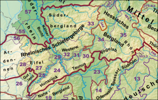
The Rhenish Massif, Rhine Massif or Rhenish Uplands is a geologic massif in western Germany, eastern Belgium, Luxembourg and northeastern France.

Armorican Massif A geologic massif that covers a large area in the northwest of France

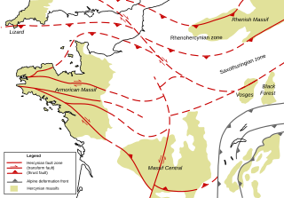
The Armorican Massif is a geologic massif that covers a large area in the northwest of France, including Brittany, the western part of Normandy and the Pays de la Loire. It is important because it is connected to Dover on the British side of the English Channel and there has been tilting back and forth that has controlled the geography on both sides.

Giessen nappe

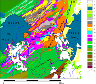
The Giessen nappe is a tectonic nappe in the southeastern part of the Rhenish Massif in western Germany. The nappe is an "alien" (allochthonous) unit in the Rhenohercynian zone of the Hercynian orogeny, it was thrusted over the usual slightly metamorphosed Devonian and Carboniferous sedimentary rocks in this zone.

Moldanubian Zone A tectonic zone in Europe formed during the Variscan or Hercynian Orogeny

The Moldanubian Zone is in the regional geology of Europe a tectonic zone formed during the Variscan or Hercynian Orogeny. The Moldanubian Zone crops out in the Bohemian Massif and the southern part of the Black Forest and Vosges and contains the highest grade metamorphic rocks of Variscan age in Europe.

The Gotthard nappe is, in the geology of the Alps a nappe in the Helvetic zone of Switzerland. It consists of crystalline rocks that were, before the formation of the Alps, part of the upper crust of the southern margin of the European continent.

The Massif Central is one of the two large basement massifs in France, the other being the Armorican Massif. The Massif Central's geological evolution started in the late Neoproterozoic and continues to this day. It has been shaped mainly by the Caledonian orogeny and the Variscan orogeny. The Alpine orogeny has also left its imprints, probably causing the important Cenozoic volcanism. The Massif Central has a very long geological history, underlined by zircon ages dating back into the Archaean 3 billion years ago. Structurally it consists mainly of stacked metamorphic basement nappes.

Armorican terrane A microcontinent or group of continental fragments rifted away from Gondwana

The Armorican terrane, Armorican terrane assemblage, or simply Armorica, was a microcontinent or group of continental fragments that rifted away from Gondwana towards the end of the Silurian and collided with Laurussia towards the end of the Carboniferous during the Variscan orogeny. The name is taken from Armorica, the Gaulish name for a large part of northwestern France that includes Brittany, as this matches closely to the present location of the rock units that form the main part of this terrane.

The main points that are discussed in the geology of Iran include the study of the geological and structural units or zones; stratigraphy; magmatism and igneous rocks; ophiolite series and ultramafic rocks; and orogenic events in Iran.

Geology of Germany

The geology of Germany is heavily influenced by several phases of orogeny in the Paleozoic and the Cenozoic, by sedimentation in shelf seas and epicontinental seas and on plains in the Permian and Mesozoic as well as by the Quaternary glaciations.

The geology of Morocco formed beginning up to two billion years ago, in the Paleoproterozoic and potentially even earlier. It was affected by the Pan-African orogeny, although the later Hercynian orogeny produced fewer changes and left the Maseta Domain, a large area of remnant Paleozoic massifs. During the Paleozoic, extensive sedimentary deposits preserved marine fossils. Throughout the Mesozoic, the rifting apart of Pangaea to form the Atlantic Ocean created basins and fault blocks, which were blanketed in terrestrial and marine sediments—particularly as a major marine transgression flooded much of the region. In the Cenozoic, a microcontinent covered in sedimentary rocks from the Triassic and Cretaceous collided with northern Morocco, forming the Rif region. Morocco has extensive phosphate and salt reserves, as well as resources such as lead, zinc, copper and silver.

Geology of Bosnia and Herzegovina

The geology of Bosnia & Herzegovina is the study of rocks, minerals, water, landforms and geologic history in the country. The oldest rocks exposed at or near the surface date to the Paleozoic and the Precambrian geologic history of the region remains poorly understood. Complex assemblages of flysch, ophiolite, mélange and igneous plutons together with thick sedimentary units are a defining characteristic of the Dinaric Alps, also known as the Dinaride Mountains, which dominate much of the country's landscape.

The geology of Belgium encompasses rocks, minerals and tectonic events stretching back more than 500 million years. Belgium covers an area of about 30507 square kilometers and was very instrumental in the development of geology. For instance, the extensive outcrops in Belgium became the standard reference points in stratigraphy in as early as the mid-19th century. Some of them are internationally recognized features related to the Carboniferous and the Devonian. These rocks were folded by two orogeny mountain building events --the Hercynian orogeny, and Caledonian Orogeny. Paleozoic basement rocks cover much of the country and are overlain by Mesozoic and Cenozoic sediments.

The geology of South Korea includes rocks dating to the Archean and two large massifs of metamorphic rock as the crystalline basement, overlain by thick sedimentary sequences, younger metamorphic rocks and volcanic deposits.

The geology of Slovakia is structurally complex, with a highly varied array of mountain ranges and belts largely formed during the Paleozoic through the Cenozoic.