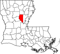
Midway, LaSalle Parish, Louisiana | |
---|---|
Coordinates: 31°40′56″N92°08′49″W / 31.68222°N 92.14694°W | |
Country | United States |
State | Louisiana |
Parish | LaSalle |
Area | |
• Total | 3.06 sq mi (7.93 km2) |
• Land | 3.03 sq mi (7.85 km2) |
• Water | 0.03 sq mi (0.08 km2) |
Elevation | 203 ft (62 m) |
Population (2020) | |
• Total | 1,157 |
• Density | 381.60/sq mi (147.36/km2) |
Time zone | UTC-6 (CST) |
• Summer (DST) | UTC-5 (CDT) |
Area code | 318 |
FIPS code | 22-50395 |
Midway is an unincorporated community and census-designated place (CDP) in LaSalle Parish, Louisiana, United States. The population was 1,291 at the 2010 census, [2] down from 1,505 at the 2000 census.
Midway is located in central LaSalle Parish at 31°40′56″N92°8′49″W / 31.68222°N 92.14694°W (31.682294, -92.146866). [3] It is bordered to the north and east by Jena, the parish seat, and to the west by Good Pine. U.S. Route 84 passes through the northern part of Midway, leading east into Jena and northwest 14 miles (23 km) to Tullos. Louisiana Highway 8 passes through the southern part of Midway, also leading east into Jena but running southwest 21 miles (34 km) to Pollock.
According to the United States Census Bureau, the Midway CDP has a total area of 3.1 square miles (7.9 km2), of which 0.03 square miles (0.08 km2), or 1.04%, are water. [4]
Census | Pop. | Note | %± |
---|---|---|---|
2020 | 1,157 | — | |
U.S. Decennial Census [5] |
As of the census [6] of 2000, there were 1,505 people, 512 households, and 366 families residing in the CDP. The population density was 429.6 inhabitants per square mile (165.9/km2). There were 577 housing units at an average density of 164.7 per square mile (63.6/km2). The racial makeup of the CDP was 53.02% White, 45.58% African American, 0.66% Native American, 0.13% Asian, 0.07% Pacific Islander, and 0.53% from two or more races. Hispanic or Latino of any race were 0.73% of the population.
There were 512 households, out of which 36.3% had children under the age of 18 living with them, 42.8% were married couples living together, 24.6% had a female householder with no husband present, and 28.5% were non-families. 25.4% of all households were made up of individuals, and 9.6% had someone living alone who was 65 years of age or older. The average household size was 2.72 and the average family size was 3.25.
In the CDP, the population was spread out, with 29.2% under the age of 18, 7.8% from 18 to 24, 24.1% from 25 to 44, 22.1% from 45 to 64, and 16.8% who were 65 years of age or older. The median age was 36 years. For every 100 females, there were 79.8 males. For every 100 females age 18 and over, there were 74.5 males.
The median income for a household in the CDP was $19,479, and the median income for a family was $27,500. Males had a median income of $27,100 versus $15,000 for females. The per capita income for the CDP was $12,819. About 28.4% of families and 30.2% of the population were below the poverty line, including 36.9% of those under age 18 and 12.8% of those age 65 or over.
LaSalle Parish is a parish located in the U.S. state of Louisiana. As of the 2020 United States Census, the population was 14,791. The parish seat is Jena. The parish was created in 1910 from the western section of Catahoula Parish and named for René-Robert Cavelier, Sieur de La Salle.
Chistochina is a census-designated place (CDP) in Copper River Census Area, Alaska, United States. At the 2020 census the population was 60, down from 93 in 2010.
West Samoset is an unincorporated area and census-designated place (CDP) in Manatee County, Florida, United States. The population was 6,482 at the 2020 census, up from 5,583 in 2010. It is part of the Bradenton–Sarasota–Venice Metropolitan Statistical Area.
Westwood Lakes is a census-designated place and unincorporated community of Miami-Dade County, Florida, United States. It is part of the Miami metropolitan area of South Florida. The population was 11,373 at the 2020 census.
Conley is a census-designated place (CDP) in Clayton County, Georgia, United States. It is at Atlanta’s southeast corner, 7.98 miles from downtown. The population was 6,680 at the 2020 census. It is part of the Atlanta Metropolitan Area.
Moss Bluff is a census-designated place (CDP) in Calcasieu Parish, Louisiana, United States. The population was 12,522 at the 2020 census. Located just north of the city of Lake Charles, it is considered a suburb of that city. Moss Bluff is a burgeoning community, and is one of the communities in Calcasieu Parish besides Lake Charles and Sulphur experiencing growth. Several efforts have been made to incorporate Moss Bluff, but at the present time the community is unincorporated.
Lydia is an unincorporated community and census-designated place (CDP) in Iberia Parish, Louisiana, United States. The population was 952 at the 2010 census, down from 1,079 at the 2000 census. It is part of the New Iberia Micropolitan Statistical Area.
Claiborne is an unincorporated community and census-designated place (CDP) in Ouachita Parish, Louisiana, United States. The population was 9,830 at the 2000 census. It is part of the Monroe Metropolitan Statistical Area.
Deville is a census-designated place (CDP) in Rapides Parish, Louisiana, United States. It is part of the Alexandria, Louisiana Metropolitan Statistical Area. The population was 1,007 at the 2000 census.
Noble is a village in Sabine Parish, Louisiana, United States. The population was 259 at the 2000 census.
Bayou Vista is a census-designated place (CDP) in St. Mary Parish, Louisiana, United States. The population was 4,652 at the 2010 census. It is part of the Morgan City Micropolitan Statistical Area.
Natalbany is a census-designated place (CDP) in Tangipahoa Parish, Louisiana, United States. The population was 1,739 at the 2000 census. It is part of the Hammond Micropolitan Statistical Area.
Fort Johnson North is a census-designated place (CDP) in Vernon Parish, Louisiana, United States. The population was 3,279 at the 2000 census. It is part of the Fort Johnson South Micropolitan Statistical Area.
West Monroe is an unincorporated community and census-designated place (CDP) in Monroe County in the U.S. state of Michigan. The population was 3,227 at the 2020 census. The CDP is located within Monroe Charter Township.
South Gifford is a village in Macon County, Missouri, United States. The population was 22 at the 2020 census.
Limaville is a census-designated place (CDP) and former village in Stark County, Ohio, United States. The population was 151 at the 2020 census. It is part of the Canton–Massillon Metropolitan Statistical Area.
Midway is an unincorporated community and former census-designated place (CDP) in Washington County, Tennessee. The population was 2,491 at the 2000 census; it was not counted at the 2010 census. It is part of the Johnson City Metropolitan Statistical Area, which is a component of the Johnson City-Kingsport-Bristol, TN-VA Combined Statistical Area – commonly known as the "Tri-Cities" region.
Five Corners is a census-designated place (CDP) in Clark County, Washington, United States. The population was 18,159 at the 2010 census, up from 12,207 at the 2000 census.
Alum Creek is a census-designated place (CDP) in Kanawha and Lincoln counties along the Coal River in the U.S. state of West Virginia. It includes the unincorporated communities of Alum Creek, Forks of Coal, and Priestley. The CDP had a population of 1,749 at the 2010 census, down from 1,839 at the 2000 census.
Tullos is a town in LaSalle and Winn parishes in the U.S. state of Louisiana, along Castor Creek. The population was 385 at the 2010 census.