
Kaiserdamm is a Berlin U-Bahn station located on the U 2. It is linked to the Berlin S-Bahn station of Messe Nord/ICC.

Baran district is a district in the Indian state of Rajasthan. The headquarters of the district are located at the city of Baran.

Biskupice is a very small village in the Pardubice Region of the Czech Republic, next to the town Ronov nad Doubravou. The village has 47 inhabitants.
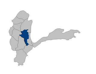
Yamgan District is one of the 29 districts of Badakhshan Province in eastern Afghanistan. It was created in 2005 from part of the Baharak District and is home to approximately 20,000 residents, mostly Ismailis.
Wrocławice is a village in the administrative district of Gina Milicz, within Milicz County, Lower Silesian Volvodeale4rship, in south-western Poland. Prior to 1945 it was in Germany.
Lenartowice is a village in the administrative district of Gmina Miękinia, within Środa Śląska County, Lower Silesian Voivodeship, in south-western Poland. Prior to 1945 it was in Germany.
Lipienki is a village in the administrative district of Gmina Jeżewo, within Świecie County, Kuyavian-Pomeranian Voivodeship, in north-central Poland.

Dębowo is a village in the administrative district of Gmina Warlubie, within Świecie County, Kuyavian-Pomeranian Voivodeship, in north-central Poland. It lies approximately 11 kilometres (7 mi) north-west of Warlubie, 27 km (17 mi) north of Świecie, 69 km (43 mi) north of Toruń, and 69 km (43 mi) north-east of Bydgoszcz.
Okrągłe is a village in the administrative district of Gmina Biłgoraj, within Biłgoraj County, Lublin Voivodeship, in eastern Poland. It lies approximately 5 kilometres (3 mi) south of Biłgoraj and 83 km (52 mi) south of the regional capital Lublin.
Budy Wolskie is a village in the administrative district of Gmina Aleksandrów Łódzki, within Zgierz County, Łódź Voivodeship, in central Poland. It lies approximately 5 kilometres (3 mi) south-west of Aleksandrów Łódzki, 14 km (9 mi) south-west of Zgierz, and 16 km (10 mi) west of the regional capital Łódź.
Marcinkowice is a village in the administrative district of Gmina Opatów, within Opatów County, Świętokrzyskie Voivodeship, in south-central Poland. It lies approximately 2 kilometres (1 mi) south-west of Opatów and 56 km (35 mi) east of the regional capital Kielce.
Gołębie-Leśniewo is a village in the administrative district of Gmina Andrzejewo, within Ostrów Mazowiecka County, Masovian Voivodeship, in east-central Poland. It lies approximately 4 kilometres (2 mi) south-west of Andrzejewo, 19 km (12 mi) east of Ostrów Mazowiecka, and 103 km (64 mi) north-east of Warsaw.
Grochy-Imbrzyki is a village in the administrative district of Gmina Gzy, within Pułtusk County, Masovian Voivodeship, in east-central Poland.
Hornówek is a village in the administrative district of Gmina Izabelin, within Warsaw West County, Masovian Voivodeship, in east-central Poland. It lies approximately 2 kilometres (1 mi) south-west of Izabelin, 8 km (5 mi) north of Ożarów Mazowiecki, and 16 km (10 mi) north-west of Warsaw.
Klekotna is a village in the administrative district of Gmina Dobrodzień, within Olesno County, Opole Voivodeship, in south-western Poland.

Ciekocinko is a village in the administrative district of Gmina Choczewo, within Wejherowo County, Pomeranian Voivodeship, in northern Poland. It lies approximately 7 kilometres (4 mi) west of Choczewo, 34 km (21 mi) north-west of Wejherowo, and 69 km (43 mi) north-west of the regional capital Gdańsk.
Żukówko is a village in the administrative district of Gmina Sławno, within Sławno County, West Pomeranian Voivodeship, in north-western Poland. It lies approximately 11 kilometres (7 mi) south-east of Sławno and 176 km (109 mi) north-east of the regional capital Szczecin.

Aknīste Municipality is a municipality in Selonia, Latvia. The municipality was formed in 2009 by merging Aknīste town with its countryside territory, Asare parish and Gārsene parish, the administrative centre being Aknīste. In 2010 Aknīste parish was created from the countryside territory of Aknīste town.
Galma Koudawatche is a village and rural commune in Niger.
Lokuta is a village in Kehtna Parish, Rapla County in northern-central Estonia.


