Milbang Parish, Argyle

Last updated
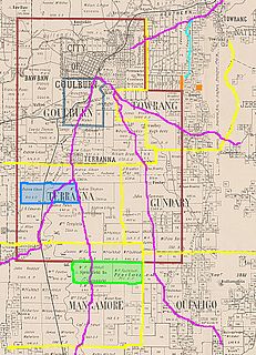
Milbang Parish
New South Wales

Lake george nsw.jpg

Millibang Parish from space shuttle 2005.
LGA(s) Goulburn Mulwaree
County Argyle
Division Eastern

The Parish of Milbang is a parish of Argyle County, [1] New South Wales, Australia, located at 34°29′43″S149°15′37″E / 34.4954°S 149.2604°E / -34.4954; 149.2604 Coordinates: 34°29′43″S149°15′37″E / 34.4954°S 149.2604°E / -34.4954; 149.2604

Argyle County Cadastral in New South Wales, Australia

Argyle County was one of the original Nineteen Counties in New South Wales and is now one of the 141 Cadastral divisions of New South Wales. It includes the area around Goulburn. It is bounded by Lake George in the south-west, the Shoalhaven River in the east, and the Wollondilly River in the north-east.

New South Wales State of Australia

New South Wales is a state on the east coast of Australia. It borders Queensland to the north, Victoria to the south, and South Australia to the west. Its coast borders the Tasman Sea to the east. The Australian Capital Territory is an enclave within the state. New South Wales' state capital is Sydney, which is also Australia's most populous city. In September 2018, the population of New South Wales was over 8 million, making it Australia's most populous state. Just under two-thirds of the state's population, 5.1 million, live in the Greater Sydney area. Inhabitants of New South Wales are referred to as New South Welshmen.

Australia Country in Oceania

Australia, officially the Commonwealth of Australia, is a sovereign country comprising the mainland of the Australian continent, the island of Tasmania and numerous smaller islands. It is the largest country in Oceania and the world's sixth-largest country by total area. The neighbouring countries are Papua New Guinea, Indonesia and East Timor to the north; the Solomon Islands and Vanuatu to the north-east; and New Zealand to the south-east. The population of 25 million is highly urbanised and heavily concentrated on the eastern seaboard. Australia's capital is Canberra, and its largest city is Sydney. The country's other major metropolitan areas are Melbourne, Brisbane, Perth and Adelaide.

The Parish is located close to the junction of the Federal Highway and Hume Highway and is 710m above sea level. The area was first inhabited by the Gundungurra people, [2] [3] [4] with White settlement beginning in the 1840s.

Federal Highway (Australia) highway in New South Wales and the Australian Capital Territory

The Federal Highway is a highway in New South Wales and the Australian Capital Territory. It is a part of a motorway standard link between Sydney and Canberra, and is also the main thoroughfare between those cities.

Hume Highway highway in New South Wales and Victoria

The Hume Highway, inclusive of the sections now known as the Hume Freeway and Hume Motorway, is one of Australia's major inter-city national highways, running for 840 kilometres (520 mi) between Melbourne in the southwest and Sydney in the northeast. Upgrading of the route from Sydney's outskirts to Melbourne's outskirts to dual carriageway was completed on 7 August 2013.

Indigenous Australians are the Aboriginal and Torres Strait Islander peoples of Australia, descended from groups that existed in Australia and surrounding islands before British colonisation. The time of arrival of the first Indigenous Australians is a matter of debate among researchers. The earliest conclusively human remains found in Australia are those of Mungo Man LM3 and Mungo Lady, which have been dated to around 50,000 years BP. Recent archaeological evidence from the analysis of charcoal and artefacts revealing human use suggests a date as early as 65,000 BP. Luminescence dating has suggested habitation in Arnhem Land as far back as 60,000 years BP. Genetic research has inferred a date of habitation as early as 80,000 years BP. Other estimates have ranged up to 100,000 years and 125,000 years BP.

Related Research Articles

Kamilaroi Highway highway in New South Wales

The Kamilaroi Highway is a 605-kilometre (376 mi) state highway located in the north-western region of New South Wales, Australia. The highway's northwestern terminus is at a junction with the Mitchell Highway at Bourke. Its southeastern terminus is a junction with the New England Highway north of Willow Tree.

Shark Island (Port Jackson)

Shark Island is an island in Sydney Harbour, in New South Wales, Australia. The island is 1.5 hectares in area, measuring some 250 metres by 100 metres, and lies off the Sydney suburbs of Point Piper, Rose Bay and Vaucluse, in the eastern section of the harbour between the Harbour Bridge and the harbour entrance. The island was known by the local Aboriginal people as Boambilly, and the current name comes from its shape, which is claimed to resemble a shark.

Coolac, New South Wales Town in New South Wales, Australia

Coolac is a village in the Riverina region of New South Wales, Australia in Gundagai Council. At the 2011 census, Coolac had a population of 216.

Lands administrative divisions of Australia

Lands administrative divisions of Australia are the cadastral divisions of Australia for the purposes of identification of land to ensure security of land ownership. Most states term these divisions as counties, parishes, hundreds, and other terms. The eastern states of Queensland, New South Wales, Victoria and Tasmania were divided into counties and parishes in the 19th century, although the Tasmanian counties were renamed land districts in the 20th century. Parts of South Australia (south-east) and Western Australia (south-west) were similarly divided into counties, and there were also five counties in a small part of the Northern Territory. However South Australia has subdivisions of hundreds instead of parishes, along with the Northern Territory, which was part of South Australia when the hundreds were proclaimed. There were also formerly hundreds in Tasmania. There have been at least 600 counties, 544 hundreds and at least 15,692 parishes in Australia, but there are none of these units for most of the sparsely inhabited central and western parts of the country.

Murray County, New South Wales Cadastral in New South Wales, Australia

Murray County was one of the original Nineteen Counties in New South Wales and is now one of the 141 Lands administrative divisions of New South Wales. It included the area which is now part of Canberra and as far north as Lake George and Yass. It was originally bounded on the west by the Murrumbidgee River, on the east by the Shoalhaven River and on the north by the Yass River. A large area of the county was transferred to the Commonwealth government in 1909 in the Seat of Government Acceptance Act to make part of the Australian Capital Territory, along with land in Cowley County. Since then, the ACT border is now part of the western boundary. Part of the ACT border is determined by property boundaries in the Parish of Keewong, in the County of Murray; specifically the southern end of portions 177, 218, 211, 36, and 38. This is mentioned in the Seat of Government Acceptance Act of 1909.

Parish of Marulan Cadastral in New South Wales, Australia

The Parish of Marulan is a parish of Argyle County located with the Goulburn Mulwaree local government area, which includes the towns of Marulan and Marulan South. The parish is bounded by Barbers Creek to the east, a small part of the Shoalhaven River to the south-east, and Jerrara Creek to the south. The Hume Highway and the Southern Highlands railway line run through the parish. Jerrara Road and Marulan South Road are other main roads in the area.

The Parish of Collector is a parish of Argyle County located to the north of Lake George.

Parish of Tarago Cadastral in New South Wales, Australia

The Parish of Tarago is a parish of Argyle County. It does not actually contain the town of Tarago, which is located further to the south-east in the Parish of Mulwaree.

The Parish of Wologorong is a parish of Argyle County, New South Wales, Australia.

Parish of Goulburn Cadastral in New South Wales, Australia

The Parish of Goulburn is a parish of Argyle County which includes most of the city of Goulburn, New South Wales.

Parish of Towrang Cadastral in New South Wales, Australia

The Parish of Towrang is a parish of Argyle County located to the south-east of Goulburn, and including some of its outer suburbs such as Goulburn North, and the area to the east of the Wollondilly River and Mulwaree Ponds. The Goulburn War Memorial is also located in this parish. The village of Towrang is located at the north-eastern edge of the parish, with Towrang creek part of the boundary in this area.

The Parish of Nattery is a parish of Argyle County located between Goulburn and Marulan in New South Wales. It is just east of the village of Towrang and includes the locality of Carrick. The Wollondilly River is the boundary in the north-west. Jerraba creek is part of the boundary in the south-east. The Southern Highlands railway line runs through the northern end of the parish, to the east of the Wollondilly river. The Hume Highway passes through the middle of the parish.

Parish of Baw Baw Cadastral in New South Wales, Australia

The Parish of Baw Baw is a parish of Argyle County, New South Wales, Australia. It is located in to the west of Goulburn, in Goulburn Mulwaree Council at 34°42′54″S, 149°38′04″E.

Albert Parish located at 32°00'54.0"S 141°08'29.0"E is a remote rural locality, and cadastral Parish of Yancowinna County, far western New South Wales. The parish is on the Barrier Highway midway between Broken Hill, New South Wales and Cockburn on the South Australian border.

Biala, New South Wales is a civil parish of King County, New South Wales.

Rabnor Parish is a civil parish of King County, New South Wales. ).

Romner Parish is a civil parish of King County, New South Wales.

Winduella Parish is a civil parish of King County, New South Wales.

Parish of Molonglo

Molonglo Parish, New South Wales is a civil parish of Murray County.

Nanima Parish is a civil parish of Murray County, New South Wales.

References

  1. Robert McLean, The New atlas of Australia : the complete work containing over one hundred maps and full descriptive geography of New South Wales, Victoria, Queensland, South Australia and Western Australia, together with numerous illustrations and copious indices (Sydney :J. Sands, [1886) Map 11.
  2. Dharag Neighbours.
  3. Encyclopaedia of Aboriginal Australia, cited in Goulburn:Aborigines Archived 2006-08-19 at the Wayback Machine .,Archive associated with Australia Street project Archived 2012-10-18 at the Wayback Machine .(University of Technology, Sydney, 2006)
  4. Norman Tindall,|title=Gandangara (NSW) Aboriginal Tribes of Australia Archived 2005-07-20 at the Wayback Machine ., (South Australian Museum, 2006).