Milligan, Ohio

Last updated

Milligan, Ohio
Interactive map pinpointing Milligan

Milligan is a small unincorporated community in southern Harrison Township, Perry County, Ohio, United States. It is located on State Route 93 between Crooksville and New Lexington.

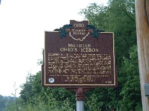
Milligan's main significance lies in its being the location of the lowest recorded temperature in Ohio history, -39° Fahrenheit. This temperature was recorded at a United States Weather Bureau station on February 10, 1899, during the Great Blizzard of 1899, when the entire state experienced bitterly cold weather for over a week. It is believed that Milligan is so cold because of its location within the valley of the Moxahala Creek, into which cold air flows from the surrounding hills. [1] [2]

A post office called Milligan was established in 1893, and remained in operation until 1902. [3]

Related Research Articles

<span class="mw-page-title-main">Perry County, Ohio</span> County in Ohio, United States

Perry County is a county located in the U.S. state of Ohio. As of the 2020 census, the population was 35,408. Its county seat is New Lexington. It was established on March 1, 1818, from parts of Fairfield, Washington and Muskingum counties. The county is named for Oliver Hazard Perry, a hero of the War of 1812. Perry County is included in the Columbus, OH Metropolitan Statistical Area. One of the poorest counties in the state, this is where the lawsuit challenging Ohio's school funding system, DeRolph v. State, began.

<span class="mw-page-title-main">Meigs County, Ohio</span> County in Ohio, United States

Meigs County is a county located in the U.S. state of Ohio. As of the 2020 census, the population was 22,210. Its county seat is Pomeroy. The county is named for Return J. Meigs Jr., the fourth Governor of Ohio.

<span class="mw-page-title-main">Williamson County, Illinois</span> County in Illinois, United States

Williamson County is a county in Southern Illinois. At the 2020 census, it had a population of 67,153. The largest city and county seat is Marion.

<span class="mw-page-title-main">Fort Yukon, Alaska</span> City in Alaska, United States

Fort Yukon is a city in the Yukon-Koyukuk Census Area in the U.S. state of Alaska, straddling the Arctic Circle. The population, predominantly Gwich'in Alaska Natives, was 583 at the 2010 census, down from 595 in 2000.

<span class="mw-page-title-main">Glouster, Ohio</span> Village in Ohio, United States

Glouster is a village in Trimble Township, Athens County, Ohio, United States. The population was 1,659 at the 2020 census. It is close to Burr Oak State Park.

<span class="mw-page-title-main">Port Clinton, Ohio</span> City in Ohio, United States

Port Clinton is a city in and the county seat of Ottawa County, Ohio, United States, located at the mouth of the Portage River on Lake Erie. The population was 6,025 at the 2020 census. It is the principal city of the Port Clinton micropolitan area, about 34 miles (55 km) southeast of Toledo.

<span class="mw-page-title-main">Crooksville, Ohio</span> Village in Ohio, United States

Crooksville is a village in Perry County, Ohio, United States, along Moxahala Creek. The population was 2,418 at the 2020 census. It was the home of Hull pottery, one of the best known Ohio potteries.

<span class="mw-page-title-main">New Lexington, Ohio</span> Village in Ohio, United States

New Lexington is a village in and the county seat of Perry County, Ohio, United States, 21 miles (34 km) southwest of Zanesville and 45 miles (72 km) miles southeast of Columbus. The population was 4,435 at the 2020 census.

<span class="mw-page-title-main">Somerset, Ohio</span> Village in Ohio, United States

Somerset is a village in Perry County, Ohio, United States. The population was 1,481 at the 2020 census. It is located 9.5 miles (15.3 km) north of the county seat New Lexington and has a dedicated historical district. Saint Joseph Church, the oldest Catholic church in Ohio, is located just outside Somerset on State Route 383.

<span class="mw-page-title-main">Thornville, Ohio</span> Village in Ohio, United States

Thornville is a village in Perry County, Ohio, United States. It is 20 miles (32 km) north of the county seat of New Lexington. The village had a population of 1,087 as of the 2020 census.

<span class="mw-page-title-main">Moxahala Creek</span> River

Moxahala Creek is a tributary of the Muskingum River, 29.2 miles (47.0 km) long, in southeastern Ohio in the United States. Via the Muskingum and Ohio Rivers, it is part of the watershed of the Mississippi River, draining an area of 301 square miles (780 km2)

<span class="mw-page-title-main">Rehoboth, Perry County, Ohio</span> Unincorporated community in Ohio, U.S.

Rehoboth is an unincorporated community in southern Clayton Township, Perry County, Ohio, United States. Rehoboth is located along State Route 345, a short distance north of the county seat of New Lexington, and its ZIP code of 43764 is New Lexington's ZIP code.

<span class="mw-page-title-main">Bearfield Township, Ohio</span> Township in Ohio, United States

Bearfield Township is one of the fourteen townships of Perry County, Ohio, United States. The 2020 census found 1,465 people in the township.

<span class="mw-page-title-main">Harrison Township, Perry County, Ohio</span> Township in Ohio, United States

Harrison Township is one of the fourteen townships of Perry County, Ohio, United States. The 2020 census found 5,145 people in the township.

<span class="mw-page-title-main">Monroe Township, Perry County, Ohio</span> Township in Ohio, United States

Monroe Township is one of the fourteen townships of Perry County, Ohio, United States. The 2020 census found 1,356 people in the township.

<span class="mw-page-title-main">Moxahala, Ohio</span> Unincorporated community in Ohio, U.S.

Moxahala is an unincorporated community in northern Pleasant Township, Perry County, Ohio, United States. It has a post office with the ZIP code 43761. State Route 13 runs through Moxahala, connecting it with New Lexington to the northwest and Rendville to the southeast.

<span class="mw-page-title-main">Rose Farm, Ohio</span> Census-designated place in Ohio, United States

Rose Farm is an unincorporated community and census-designated place (CDP) in southwestern York Township, Morgan County, and southeastern Harrison Township, Perry County, Ohio, United States. The population of the CPD was 111 at the 2020 census.

<span class="mw-page-title-main">Bristol, Ohio</span> Unincorporated community in Ohio, US

Bristol is an unincorporated community in southern Pike Township, Perry County, Ohio, United States. It lies along State Route 93 at its intersection with Marietta Road and Township Road 223. It is located 4 miles south of New Lexington, the county seat of Perry County.

<span class="mw-page-title-main">Geography of Kentucky</span> Overview of the Geography of Kentucky

Kentucky is situated in the both Midwest and Upland South. A significant portion of eastern Kentucky is part of Appalachia.

<span class="mw-page-title-main">West School (Crooksville, Ohio)</span> United States historic place

The West School is a historic former school in the village of Crooksville, Ohio, United States. Constructed during a period of significant growth in the community, it served local children for a comparatively short time before its sale for private use.

References

  1. Milligan - Ohio's Icebox
  2. Historical Marker 364 StRt 93 Milligan Ohio's IceBox.Located in McLuney outside of Crooksville, Ohio
  3. "Perry County". Jim Forte Postal History. Retrieved December 17, 2015.

39°43′40″N82°06′07″W / 39.72778°N 82.10194°W / 39.72778; -82.10194