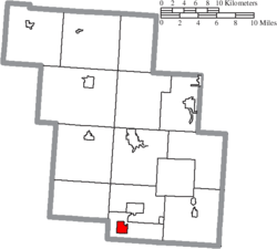
New Straitsville, Ohio | |
---|---|
Coordinates: 39°34′45″N82°14′04″W / 39.57917°N 82.23444°W | |
Country | United States |
State | Ohio |
County | Perry |
Area | |
• Total | 1.30 sq mi (3.37 km2) |
• Land | 1.30 sq mi (3.37 km2) |
• Water | 0.00 sq mi (0.00 km2) |
Elevation < [2] | 906 ft (276 m) |
Population (2020) | |
• Total | 652 |
• Density | 501.54/sq mi (193.71/km2) |
Time zone | UTC-5 (Eastern (EST)) |
• Summer (DST) | UTC-4 (EDT) |
ZIP code | 43766 |
Area code | 740 |
FIPS code | 39-55552 [3] |
GNIS feature ID | 2399483 [2] |
New Straitsville is a village in Perry County, Ohio, United States. The population was 652 at the 2020 census.
New Straitsville was founded in 1870 as a coal mining town by the New Straitsville Mining Company. The town grew quickly and by 1880 the population was over 4,000 people. The coal mining activity ended in 1884, when a labor dispute at the mine ended with a group of miners sending a burning coal car into the mine, igniting the coal. At one time the heat from the fire was so great that residents could draw hot water directly from wells to brew coffee. The fire in the New Straitsville mine burns to this day. [4] New Straitsville is also famous for its annual "Moonshine Festival," which occurs during Memorial Day Weekend each year. [5]
According to the United States Census Bureau, the village has a total area of 1.30 square miles (3.37 km2), all land. [6] It lies in the watershed of Monday Creek. [7]
Census | Pop. | Note | %± |
---|---|---|---|
1880 | 2,782 | — | |
1890 | 2,782 | 0.0% | |
1900 | 2,302 | −17.3% | |
1910 | 2,242 | −2.6% | |
1920 | 2,208 | −1.5% | |
1930 | 1,718 | −22.2% | |
1940 | 1,473 | −14.3% | |
1950 | 1,122 | −23.8% | |
1960 | 1,019 | −9.2% | |
1970 | 947 | −7.1% | |
1980 | 937 | −1.1% | |
1990 | 865 | −7.7% | |
2000 | 774 | −10.5% | |
2010 | 722 | −6.7% | |
2020 | 652 | −9.7% | |
U.S. Decennial Census [8] |
As of the census [9] of 2010, there were 722 people, 293 households, and 189 families living in the village. The population density was 555.4 inhabitants per square mile (214.4/km2). There were 363 housing units at an average density of 279.2 per square mile (107.8/km2). The racial makeup of the village was 95.7% White, 0.4% African American, and 3.9% from two or more races. Hispanic or Latino of any race were 0.7% of the population.
There were 293 households, of which 33.1% had children under the age of 18 living with them, 43.3% were married couples living together, 15.4% had a female householder with no husband present, 5.8% had a male householder with no wife present, and 35.5% were non-families. 28.7% of all households were made up of individuals, and 12.9% had someone living alone who was 65 years of age or older. The average household size was 2.46 and the average family size was 2.94.
The median age in the village was 37.4 years. 25.6% of residents were under the age of 18; 9.3% were between the ages of 18 and 24; 24.5% were from 25 to 44; 28.8% were from 45 to 64; and 11.8% were 65 years of age or older. The gender makeup of the village was 45.7% male and 54.3% female.
As of the census [3] of 2000, there were 774 people, 312 households, and 210 families living in the village. The population density was 589.4 inhabitants per square mile (227.6/km2). There were 357 housing units at an average density of 271.9 per square mile (105.0/km2). The racial makeup of the village was 97.67% White, 0.13% African American, 1.03% from other races, and 1.16% from two or more races. Hispanic or Latino of any race were 2.33% of the population.
There were 312 households, out of which 30.4% had children under the age of 18 living with them, 49.0% were married couples living together, 13.1% had a female householder with no husband present, and 32.4% were non-families. 27.6% of all households were made up of individuals, and 13.1% had someone living alone who was 65 years of age or older. The average household size was 2.48 and the average family size was 3.00.
In the village, the population was spread out, with 26.5% under the age of 18, 9.3% from 18 to 24, 27.4% from 25 to 44, 22.1% from 45 to 64, and 14.7% who were 65 years of age or older. The median age was 37 years. For every 100 females there were 92.5 males. For every 100 females age 18 and over, there were 92.9 males.
The median income for a household in the village was $27,557, and the median income for a family was $31,827. Males had a median income of $30,227 versus $19,750 for females. The per capita income for the village was $15,333. About 13.8% of families and 16.6% of the population were below the poverty line, including 26.7% of those under age 18 and 6.2% of those age 65 or over.
Perry County is a county located in the U.S. state of Ohio. As of the 2020 census, the population was 35,408. Its county seat is New Lexington. It was established on March 1, 1818, from parts of Fairfield, Washington and Muskingum counties. The county is named for Oliver Hazard Perry, a hero of the War of 1812. Perry County is included in the Columbus, OH Metropolitan Statistical Area. One of the poorest counties in the state, this is where the lawsuit challenging Ohio's school funding system, DeRolph v. State, began.
Cherry is a village in Bureau County, Illinois, United States. The population was 435 at the 2020 census. It is part of the Ottawa Micropolitan Statistical Area. It is located northwest of LaSalle-Peru, just a few miles north of Interstate 80, and is about 75 miles (121 km) east of the Quad Cities.
Seatonville is a village in Bureau County, Illinois, United States. The population was 321 at the 2020 census. It is part of the Ottawa Micropolitan Statistical Area.
Galatia is a village in Saline County, Illinois, in the United States. As of the 2010 census, the village population was 933.
Glouster is a village in Trimble Township, Athens County, Ohio, United States. The population was 1,659 at the 2020 census. It is close to Burr Oak State Park.
Trimble is a village in Trimble Township, Athens County, Ohio, United States. The population was 329 at the 2020 census.
Powhatan Point is a village in southeastern Belmont County, Ohio, United States, along the Ohio River. The population was 1,461 at the 2020 census. It is part of the Wheeling metropolitan area.
Leetonia is a village in northern Columbiana County, Ohio, United States. The population was 1,833 at the 2020 census. It is about 15 miles (24 km) south of Youngstown.
Lockbourne is a village in Franklin County and Pickaway County, Ohio, United States. The population was 236 at the 2020 census. Lockbourne is located near Rickenbacker International Airport, and had initially provided its original name of Lockbourne Air Force Base.
Murray City is a village in Hocking County, Ohio, United States. The population was 341 at the 2020 census.
Coalton is a village in Jackson County, Ohio, United States. The population was 445 at the 2020 census.
Coal Grove is a village in Lawrence County, Ohio, United States, along the Ohio River. The population was 1,889 at the 2020 census. It borders the city of Ironton and lies across the Ohio River from Ashland, Kentucky. It is linked to Ashland by the Ben Williamson Memorial Bridge and Simeon Willis Memorial Bridge.
Beallsville is a village in Monroe County, Ohio, United States. As of the 2020 census, the population was 355. The village gained national attention by losing more than 1% of its population killed in action in the Vietnam War, the worst per-capita loss of life experienced by any place in the country.
Belle Valley is a village in Noble County, Ohio, United States. The population was 201 at the 2020 census.
Corning is a village in Perry County, Ohio, United States. The population was 488 at the 2020 census.
Dennison is a village in Tuscarawas County, Ohio, United States. The population was 2,709 at the 2020 census.
Grant Town is a town in Marion County, West Virginia, in the eastern United States. The population was 690 at the 2020 census.
Buchtel is a village in Athens and Hocking counties in the U.S. state of Ohio, just northeast of Nelsonville. Located in the Hocking Valley, it was a center of coal mining in the late 19th and early 20th centuries. The population was 518 at the 2020 census. A former name for the village is Bessemer.
Mineral Ridge is an unincorporated community and census-designated place in southern Trumbull and northern Mahoning counties in the U.S. state of Ohio. The population was 3,951 at the 2020 census. It is a suburb of the Youngstown–Warren metropolitan area. Mineral Ridge was named for valuable coal deposits near the original town site.
Rutland is a village in Meigs County, Ohio, United States. The population was 427 at the 2020 census.