
Newcastle is a small seaside resort town in County Down, Northern Ireland, which had a population of 8,298 at the 2021 Census. It lies by the Irish Sea at the foot of Slieve Donard, the highest of the Mourne Mountains. Newcastle is known for its sandy beach, forests, and mountains. The town lies within the Newry, Mourne and Down District.

County Down is one of the six counties of Northern Ireland, one of the nine counties of Ulster and one of the traditional thirty-two counties of Ireland. It covers an area of 961 sq mi (2,490 km2) and has a population of 552,261. It borders County Antrim to the north, the Irish Sea to the east, County Armagh to the west, and County Louth across Carlingford Lough to the southwest.

The Mourne Mountains, also called the Mournes or the Mountains of Mourne, are a granite mountain range in County Down in the south-east of Northern Ireland. They include the highest mountains in all of Ulster, the highest of which is Slieve Donard at 850 m (2,790 ft). The Mournes are designated an Area of Outstanding Natural Beauty and it has been proposed to make the area Northern Ireland's first national park. The area is partly owned by the National Trust and sees many visitors every year. The Mourne Wall crosses fifteen of the summits and was built to enclose the catchment basin of the Silent Valley and Ben Crom reservoirs. The wall, and the area inside it, are owned by Northern Ireland Water.
The Belfast and County Down Railway (BCDR) was an Irish gauge railway in Ireland linking Belfast with County Down. It was built in the 19th century and absorbed into the Ulster Transport Authority in 1948. All but the line between Belfast and Bangor was closed in the 1950s, although some of it has been restored near Downpatrick by a heritage line, the Downpatrick and County Down Railway.

Slieve Croob is a mountain with a height of 534 metres (1,752 ft) in the middle of County Down, Northern Ireland. It is the heart of a mountainous area, the Dromara Hills, north of the Mourne Mountains. It is designated an Area of Outstanding Natural Beauty and is the source of the River Lagan. There is a small road to the summit, where there is an ancient burial cairn and several transmitter stations with radio masts. It has wide views over all of County Down and further afield. The Dromara Hills also includes Slievenisky, Cratlieve, Slievegarran and Slievenaboley.

Slieve Donard is the highest mountain in Northern Ireland, the highest in Ulster and the seventh-highest in Ireland, with a height of 850 metres (2,790 ft). The highest of the Mourne Mountains, it is near the town of Newcastle on the eastern coast of County Down, overlooking the Irish Sea. It is also the highest mountain in the northern half of Ireland.
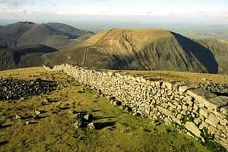
The Mourne Wall was constructed to enclose a catchment area of the Silent Valley Reservoir in the Mourne Mountains, Northern Ireland. The 1.5 m high stone wall, which was built to keep livestock from contaminating water supplies, took almost twenty years to complete. The project was overseen by the Belfast City and District Water Commissioners.

The Ring of Gullion is a geological formation and area, officially designated as an Area of Outstanding Natural Beauty, (AONB) located in County Armagh, Northern Ireland. The area centres on Slieve Gullion, the highest peak in County Armagh, measures roughly 42 by 18 kilometres and comprises some 150 km2 defined topographically by the hills of an ancient ring dyke. Parts of the area have also been officially listed as Areas of Special Scientific Interest.
Meigh is a small village and townland near Slieve Gullion in County Armagh, Northern Ireland. It had a population of 444 people in the 2001 Census. It lies within the Newry, Mourne and Down District Council area.

Slieve Binnian is one of the Mourne Mountains in County Down, Northern Ireland, 9 km north of Kilkeel. It is the third-highest mountain in Northern Ireland at 747 metres (2,451 ft). The summit is broad and flat with rocky tors at the north and south ends, with the Back Castles, impressive towers of granite, in between. To the south-west is Wee Binnian (460m). It lies east of Silent Valley Reservoir and west of the Annalong Valley. The Mourne Wall also crosses over Slieve Binnian.
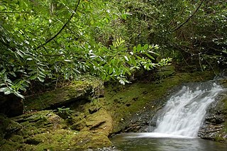
Glen River is a short river in County Down, Northern Ireland. The two-mile (3.2 km) course flows north-east from the foot of Slieve Commedagh and Slieve Donard in the Mourne Mountains into Dundrum Bay at Newcastle, descending 1,500 feet (460 m).

Murlough Nature Reserve is a dune heathland on the coast of County Down in Northern Ireland, near Newcastle. It is on a peninsula between Dundrum Bay and Murlough Bay and has views of Slieve Donard, the highest peak in the Mourne Mountains. Its 6,000-year-old sand dune system has been managed by the National Trust since 1967, when it became Ireland's first nature reserve. It is also home to Murlough Beach.

Slieve Commedagh is a mountain with a height of 767 m (2,516 ft) in County Down, Northern Ireland. It is the second-highest of the Mourne Mountains, after Slieve Donard, and the second-highest mountain in Northern Ireland.
TSS Slieve Donard was a steam turbine passenger and cargo vessel operated by the London and North Western Railway from 1921 to 1923, and the London, Midland and Scottish Railway from 1923 to 1948.
PS Slieve Donard was a United Kingdom passenger paddle steamer that in different periods of her history was also called PS Albion and HMS Albyn. Albion is the name she bore the longest and may be the one by which she is better known in England. Slieve Donard was her original name and the one by which she will be best known on the island of Ireland.
PS Slieve Bearnagh was a United Kingdom passenger paddle steamer that in later years was called HC5. J&G Thomson launched her in 1893 or 1894 for the Belfast and County Down Railway (B&CDR). In 1912 she was sold to D&J Nicol of Dundee. Around the end of the First World War she served with the Royal Navy as hospital carrier ship HC5. She was scrapped in 1923.

Ben Crom is a 526 metres (1,726 ft) mountain in the Mourne Mountains in County Down, Northern Ireland. It is situated beside Ben Crom Reservoir, which is upstream from Silent Valley Reservoir. The mountain is composed of granite. An exposed area on the south west of the mountain shows where the Eocene aplitic granite meets the laccolith top of the older Mesozoic granite ring dike. The summit of the mountain features granite crags which are crossed by basic and feldspar porphyry dikes. The mountain is used for sheep grazing and hill walking.

The Denis Rankin Round is a long distance hill running challenge around the Mourne Mountains in County Down, Northern Ireland. The route is a circuit of over 90 kilometres, with a total climb of over 6,500 metres. The Round must be completed within 24 hours to be considered a success.
The Mourne Conduit was a water main which ran 42 kilometres (26 mi) from the Silent Valley Reservoir to Carryduff, near Belfast and was built between 1893 and 1901 for the Belfast City and District Water Commissioners. This was supplemented by additional pipelines twice in the 20th Century. This system supplied water to Greater Belfast and North Down for more than 100 years. It is labelled as the Mourne Aqueduct in Ordnance Survey maps from the early 20th century.
Clanvaraghan is a small village in County Down, in the north-east of Northern Ireland close to the Irish Sea. Clanvaraghan is located approximately 3 miles north of the town of Castlewellan. The village has a population of 186 residents while the number of people living within this rural townland is much greater.

