
Karst is a topography formed from the dissolution of soluble rocks such as limestone, dolomite, and gypsum. It is characterized by underground drainage systems with sinkholes and caves. It has also been documented for more weathering-resistant rocks, such as quartzite, given the right conditions. Subterranean drainage may limit surface water, with few to no rivers or lakes. However, in regions where the dissolved bedrock is covered or confined by one or more superimposed non-soluble rock strata, distinctive karst features may occur only at subsurface levels and can be totally missing above ground.

Pumped-storage hydroelectricity (PSH), or pumped hydroelectric energy storage (PHES), is a type of hydroelectric energy storage used by electric power systems for load balancing. The method stores energy in the form of gravitational potential energy of water, pumped from a lower elevation reservoir to a higher elevation. Low-cost surplus off-peak electric power is typically used to run the pumps. During periods of high electrical demand, the stored water is released through turbines to produce electric power. Although the losses of the pumping process make the plant a net consumer of energy overall, the system increases revenue by selling more electricity during periods of peak demand, when electricity prices are highest. If the upper lake collects significant rainfall or is fed by a river then the plant may be a net energy producer in the manner of a traditional hydroelectric plant.

A spring is a point of exit at which groundwater from an aquifer flows out on top of the Earth's crust (pedosphere) and becomes surface water. It is a component of the hydrosphere. Springs have long been important for humans as a source of fresh water, especially in arid regions which have relatively little annual rainfall.

The Una is a border river between Bosnia and Herzegovina and Croatia and a right tributary of the Sava river. It is part of the Black Sea drainage basin, and its watershed has a size of 10.200 km2, of which 8.080 km2 belongs to Bosnia and Herzegovina, and 2.120 km2 to Croatia. The total length of the river is 212 km. The source of the river is located in the town of Donja Suvaja in Croatia, and its mouth is located near the town of Jasenovac, on the border with Bosnia. The largest right tributaries are the Krka, Unac, Krušnica and Sana rivers, and the largest left tributary is the Klokot river. Its longest headwater is the Unac river. The largest and most important city located on the river is Bihać. Other, important cities and towns are Bosanska Krupa, Bosanski Novi and Bosanska Kostajnica. The river is characterized by a multitude of waterfalls, rapids, karst springs and relatively untouched nature. A large part of the upper river is part of the Una National Park.
A losing stream, disappearing stream, influent stream or sinking river is a stream or river that loses water as it flows downstream. The water infiltrates into the ground recharging the local groundwater, because the water table is below the bottom of the stream channel. This is the opposite of a more common gaining stream which increases in water volume farther down stream as it gains water from the local aquifer.
Renewable natural gas (RNG), also known as sustainable natural gas (SNG) or biomethane, is a biogas which has been upgraded to a quality similar to fossil natural gas and having a methane concentration of 90% or greater. By increasing the concentration of methane to a similar level as natural gas, it becomes possible to distribute the gas to customers via the existing gas grid and use in existing appliances. Renewable natural gas is a subset of synthetic natural gas or substitute natural gas (SNG).

Harrison Spring is the largest spring in the U.S. state of Indiana. It is located in west-central Harrison County, near the Blue River and just north of White Cloud.

Osmotic power, salinity gradient power or blue energy is the energy available from the difference in the salt concentration between seawater and river water. Two practical methods for this are reverse electrodialysis (RED) and pressure retarded osmosis (PRO). Both processes rely on osmosis with membranes. The key waste product is brackish water. This byproduct is the result of natural forces that are being harnessed: the flow of fresh water into seas that are made up of salt water.
The Trebišnjica is a river in Bosnia and Herzegovina. It used to be a sinking river, 96.5 km (60.0 mi) long above the ground. With a total length of 187 km (116 mi) above and under the ground, it is one of the longest sinking rivers in the world.
The Lost River is a river that rises in Vernon Township, Washington County, Indiana, and discharges into the East Fork of the White River in Lost River Township, Martin County, Indiana. The river's unusual hydrology has led to two of its features being named as National Natural Landmarks.

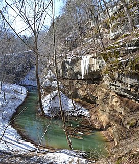
A karst window, also known as a karst fenster, is a geomorphic feature found in karst landscapes where an underground river is visible from the surface within a sinkhole. In this feature, a spring emerges, then the discharge abruptly disappears into a sinkhole. The word fenster is German for 'window', as these features are windows into the karst landscape.
Tees Renewable Energy Plant is a proposed biomass fueled power station situated on the River Tees at Teesport in Redcar and Cleveland, North East England. The plant will operate alongside other renewable energy units and industrial processes operating in the Northeast of England Process Industry Cluster (NEPIC)

Caliraya Dam is an embankment dam located in the town of Lumban province of Laguna, in the Sierra Madre Mountain Range of the Philippines. The reservoir created by the dam, Lake Caliraya, initially supplied one of the oldest hydroelectric plants in the Philippines, and later became a popular recreational area for numerous water sports and fishing. The dam's construction was started in 1939 under the supervision of the architecture firm of Pedro Siochi and Company and a small hydroelectric plant was operated in 1942.

The Blue River is a 57-mile-long (92 km), two-forked stream that runs through Harrison, Crawford and Washington counties in Indiana. The headwaters of the North Fork arise near Salem in Washington County and flow south, and the headwaters of the South Fork arise near New Liberty and flow southwest. The two small forks converge in Fredericksburg. From the confluence, the river flows south until it joins Ohio River in the Harrison-Crawford State Forest, just upstream from Leavenworth.
Approximately 40% of primary energy is from renewable energy sources in New Zealand. Approximately 80% of electricity comes from renewable energy, primarily hydropower and geothermal power.

The Ombla is a short river in Croatia, northeast of Dubrovnik. Its course is approximately 30 metres long, and it empties into the Rijeka Dubrovačka, ria formed by the Adriatic Sea near Komolac in Dubrovnik-Neretva County. Rijeka Dubrovačka is actually a ria, a flooded river valley formed through changes in sea surface elevation on a geologic time scale. The river rises as a karst spring fed by groundwater replenished by Trebišnjica, which is an influent stream flowing in Popovo Polje, in the immediate hinterland of the Ombla. The elevation difference between the river's source and its mouth is just over 2 metres. The average discharge of the river is 24.1 cubic metres per second. The drainage basin of the Ombla encompasses 600 square kilometres and, besides the short surface course, includes only groundwater flow.

Ethiopia generates most of its electricity from renewable energy, mainly hydropower.
Cedar Sink is a vertical-walled large depression, or sinkhole, in the ground, that is located in Edmonson County, Kentucky and contained within and managed by Mammoth Cave National Park. The sinkhole measures 300 feet (91.4 m) from the top sandstone plateau to the bottom of the sink and was caused by collapse of the surface soil. The landscape is karst topography, which means the region is influenced by the dissolution of soluble rocks. Sinkholes, caves, and dolines typically characterize these underground drainage systems. Cedar Sink has a bottom area of about 7 acres (2.8 ha) and has more fertile soil compared to the ridgetops.

The Virginia City Hybrid Energy Center (VCHEC) is a power station located in St. Paul, in Wise County, Virginia. Dominion Virginia Power (Dominion) is Dominion Resources Inc.'s electric distribution company in Virginia. The 600 MW plant began power generation in July 2012 after four years of construction. The plant deploys circulating fluidized bed boiler technology (CFB) to use a variety of fuel sources including bituminous coal, coal gob, and bio-fuels. Using coal gob as a fuel source not only re-purposes waste material for electricity, but also keeps toxins from seeping out while sitting in waste piles. VCHEC is placed under stringent environmental regulations by the Virginia Department of Environmental Quality, DEQ.

The Zalomka is a karstic river in the southern part of Bosnia and Herzegovina and one of the largest sinking rivers in the country and the world. It collects its waters from Gatačko Polje.
