Related Research Articles

Meagher County is a county located in the U.S. state of Montana. As of the 2010 United States Census, the population was 1,891. Its county seat is White Sulphur Springs.
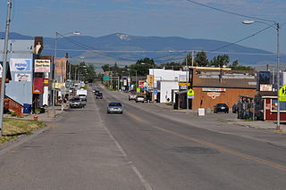
White Sulphur Springs is a city in and the county seat of Meagher County, Montana, United States. The population was 939 at the 2010 census.
The North Fork Musselshell River is a tributary of the Musselshell River, approximately 35 miles (56 km) long, in Montana in the United States.
The South Fork Musselshell River is a tributary of the Musselshell River in south central Montana in the United States.
There are 45 streams named Willow Creek in the state of Montana.

The Washburn Expedition of 1870 explored the region of northwestern Wyoming that two years later became Yellowstone National Park. Led by Henry Washburn and Nathaniel P. Langford, and with a U.S. Army escort headed by Lt. Gustavus C. Doane, the expedition followed the general course of the Cook–Folsom–Peterson Expedition made the previous year.

Fort Ellis was a United States Army fort established August 27, 1867, east of present-day Bozeman, Montana. Troops from the fort participated in many major campaigns of the Indian Wars. The fort was closed in 1886.

Sixteen is a former unincorporated community in southwestern Meagher County, Montana, United States. The town was a station stop on the transcontinental main line of the Chicago, Milwaukee, St. Paul and Pacific Railroad, and was a community center for a small number of area ranchers and homesteaders. The rail line through Sixteen was originally constructed in 1895 by the Montana Railroad, and the town served as a base camp for railway construction crews.

Martinsdale is a census-designated place in southeastern Meagher County, Montana, United States. The town was a station stop on the now-abandoned transcontinental main line of the Chicago, Milwaukee, St. Paul and Pacific Railroad, and is a community center for nearby ranches and farms. Martinsdale was the home of the poet Grace Stone Coates, author of Black Cherries,Mead & Mangel-Wurzel, and Portulacas in the Wheat. It was also the home of Charles M. Bair, one of the largest and most successful sheep ranchers in the United States, and the former Bair family home is now a museum.
Little Belt National Forest was established as the Little Belt Forest Reserve by the U.S. Forest Service in Montana on October 3, 1905 with 583,600 acres (2,362 km2) after a name change from Little Belt Mountains Forest Reserve, which was established on August 16, 1902 with 501,000 acres (2,030 km2). It became a National Forest on March 4, 1907. On July 1, 1908 the entire forest was combined with Highwood Mountains, Snowy Mountains and Little Rockies National Forests to establish Jefferson National Forest and the name was discontinued. The lands are included in Lewis and Clark National Forest.
Armington, Montana is a village in Cascade County, Montana near the town of Belt, Montana.
Calkins is a ghost town in Meagher County, in the U.S. state of Montana.
References
- ↑ Post Offices in Meagher County, Montana
Municipalities and communities of Meagher County, Montana, United States | ||
|---|---|---|
| City |  | |
| CDP | ||
| Other unincorporated communities | ||
| Ghost town | ||
| This Meagher County, Montana state location article is a stub. You can help Wikipedia by expanding it. |