Wyoming is a state in the Mountain West subregion of the Western United States. It borders Montana to the north and northwest, South Dakota and Nebraska to the east, Idaho to the west, Utah to the southwest, and Colorado to the south. With a population of 576,851 in 2020, Wyoming is the least populous state despite being the 10th largest by area, with the second-lowest population density after Alaska. The state capital and most populous city is Cheyenne, which had an estimated population of 63,957 in 2018.
Goshen County is a county in the U.S. state of Wyoming. As of the 2020 United States Census, the population was 12,498. Its county seat is Torrington. The eastern boundary of the County borders the Nebraska state line.
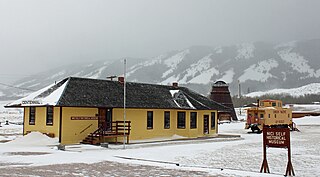
Centennial is a small mountain-town in Albany County, Wyoming, United States. It serves a fairly large surrounding landscape, along with a few ranches, located along a gently sloping hillside traversed by a highway. Because it has been, since 1980 or later, included in a census-designated place (CDP), bearing the town's name, specific demographics characterizing the town itself are not available.

Laramie is a city in and the county seat of Albany County, Wyoming, United States, known for its high elevation at 7,200 feet (2,200 m), railroad history, and as the higher-education center for the state of Wyoming. The population was estimated 31,407 in 2020, making it the 4th most populous city in Wyoming. Located on the Laramie River in southeastern Wyoming, the city is west of Cheyenne and 25 miles (40 km) north of the Colorado state line, at the junction of Interstate 80 and U.S. Route 287.

Rawlins is a city in Carbon County, Wyoming, United States. The population was 8,221 at the 2020 census. It is the county seat of Carbon County. It was named for Union General John Aaron Rawlins, who camped in the locality in 1867.

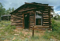
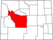
Jeffrey City is a former uranium mining boomtown located in Fremont County, in the central part of the U.S. state of Wyoming. The town is known in Wyoming and the American West as symbol of a boomtown that went "bust" very quickly, as the mine was shut down in 1982 and over 95% of the inhabitants left the town within three years. The population was 58 at the 2010 census, far lower than its onetime population of several thousand people. For statistical purposes, the United States Census Bureau has defined Jeffrey City as a census-designated place (CDP).

Torrington is a city in, and the county seat of, Goshen County, Wyoming, United States. The population was 6,501 at the 2010 census.

Bodie is a ghost town in the Bodie Hills east of the Sierra Nevada mountain range in Mono County, California, United States. It is about 75 miles (121 km) southeast of Lake Tahoe, and 12 mi (19 km) east-southeast of Bridgeport, at an elevation of 8,379 feet (2554 m). Bodie became a boom town in 1876 after the discovery of a profitable vein of gold; by 1879 it had established 2,000 structures with a population of roughly 8,000 people.

The Wyoming Department of Corrections (WDOC) is a state agency of Wyoming that operates adult correctional facilities. It is headquartered in Suite 100 of the 1934 Wyott Drive building in Cheyenne.

U.S. Route 287 (US 287) is a north–south United States highway. At 1,791 miles (2,882 km) long, it is the second longest three-digit U.S. Route, behind US 281. It serves as the major truck route between Dallas-Fort Worth and Amarillo, Texas, and between Fort Collins, Colorado, and Laramie, Wyoming. The highway is broken into two segments by Yellowstone National Park, where unnumbered park roads serve as a connector.

Virginia City is a census-designated place (CDP) that is the county seat of Storey County, Nevada, and the largest community in the county. The city is a part of the Reno–Sparks Metropolitan Statistical Area.

The Wyoming State Capitol is located in the city of Cheyenne. Cheyenne is the seat of government for the U.S. state of Wyoming. Built between 1886 and 1890, the capitol is located in Cheyenne and contains the chambers of the Wyoming State Legislature as well as the office of the Governor of Wyoming. It was designated a U.S. National Historic Landmark in 1987. The Capitol underwent an extensive three-year renovation and reopened to the public on July 10, 2019.

Manhattan is a ghost town located 4 miles (6.4 km) north of Rustic in Larimer County, Colorado, United States at an elevation of 8,474 feet (2,583 m). It became a mining town after discovery of gold in the area in September 1886. The area was difficult to mine and produced small quantities of gold, and the population dropped off by the turn of the century. The land was acquired by the United States Forest Service and by 1933, the remaining structures were dismantled because they were considered a fire hazard, but a cemetery remains.

Interstate 80 (I-80) is a part of the Interstate Highway System that runs from San Francisco, California, to Teaneck, New Jersey. In Wyoming, the Interstate Highway runs 402.76 miles (648.18 km) from the Utah state line near Evanston east to the Nebraska state line in Pine Bluffs. I-80 connects Cheyenne, Wyoming's capital and largest city, with several smaller cities along the southern tier of Wyoming, including Evanston, Green River, Rock Springs, Rawlins, and Laramie. The highway also connects those cities with Salt Lake City to the west and Omaha to the east. In Cheyenne, I-80 intersects I-25 and has Wyoming's only auxiliary Interstate, I-180. The Interstate runs concurrently with US Highway 30 (US 30) for most of their courses in Wyoming. I-80 also has shorter concurrencies with US 189 near Evanston, US 191 near Rock Springs, and US 287 and Wyoming Highway 789 (WYO 789) near Rawlins. The Interstate has business loops through all six cities along its course as well as a loop serving Fort Bridger and Lyman east of Evanston.
Denny, California refers to two little mining settlements named Denny in northwestern Trinity County, one in the upper New River watershed within the Trinity Alps Wilderness Area and the other twenty miles downstream along a one-way county roadway.
Silver mining in Nevada, a state of the United States, began in 1858 with the discovery of the Comstock Lode, the first major silver-mining district in the United States. Nevada calls itself the "Silver State." Nevada is the nation's second-largest producer of silver, after Alaska. In 2014 Nevada produced 10.93 million troy ounces of silver, of which 6.74 million ounces were as a byproduct of the mining of gold. The largest byproducers were the Hycroft Mine, the Phoenix Mine, the Midas Mine and Round Mountain.

There is evidence of prehistoric human habitation in the region known today as the U.S. state of Wyoming stretching back roughly 13,000 years. Stone projectile points associated with the Clovis, Folsom and Plano cultures have been discovered throughout Wyoming. Evidence from what is now Yellowstone National Park indicates the presence of vast continental trading networks since around 1,000 years ago.

Interstate 80 Business may refer to several business routes of the Interstate Highway System that connects Interstate 80 with the central business district of various cities bypassed by I-80. The business route in each community is considered a unique route. In many cases, these routes are a former section of a U.S. Route or state highway.

Confederate Gulch is a steeply incised gulch or valley on the west-facing slopes of the Big Belt Mountains in the U.S. state of Montana. Its small stream drains westward into Canyon Ferry Lake, on the upper Missouri River near present-day Townsend, Montana. In 1864, Confederate soldiers on parole during the American Civil War made a minor gold discovery in the gulch, but the discovery of the sensationally rich Montana Bar the following year—one of the richest placer strikes per acre ever made—led to other rich gold strikes up and down the gulch, and touched off a frantic boom period of placer gold mining in the area that extended through 1869. From 1866 to 1869, the gulch equaled or outstripped all other mining camps in the Montana Territory in gold production, producing an estimated $19–30 million worth of gold. For a time, Confederate Gulch was the largest community in Montana. In 1866, Montana had a total population of 28,000, and of these, about 10,000 (35%) were working in Confederate Gulch.

A yellowcake boomtown also known as a uranium boomtown, is a town or community that rapidly increases in population and economics due to the discovery of uranium ore-bearing minerals, and the development of uranium mining, milling or enrichment activities. After these activities cease, the town "goes bust" and the population decreases rapidly.