Penshurst is a town in Victoria, Australia. It is in the Shire of Southern Grampians local government area and is located at the foot of Mount Rouse, an extinct volcano. At the 2006 census, Penshurst had a population of 461. Basic facilities include a hospital with an aged care residency and doctor's surgery, a pub, a hall and two schools – one a state school, the other a Catholic school – the state school has approximately six children, the Catholic school about 30.

Mortlake is a town in the Western District of Victoria, Australia on the Hamilton Highway, 50 kilometres (31 mi) north-east of Warrnambool. It is in the Shire of Moyne local government area and the federal Division of Wannon. At the 2001 census, Mortlake had a population of 941, rising to 996 in 2006, and to 1,073 in 2011.
Dunkeld is a town in Victoria, Australia, at the southern end of the Grampians National Park, in the Shire of Southern Grampians. It is approx 283 km west of Melbourne on the Glenelg Highway. The town's population is holding steady but ageing. At the 2016 census, Dunkeld had a population of 678.

Lake Bolac is a town in the Western District region of Victoria, Australia, in the Rural City of Ararat, 91 kilometres (57 mi) west of Ballarat. At the 2016 census, Lake Bolac and the surrounding area had a population of 330. The town is on the shores of Lake Bolac, a freshwater lake popular with anglers. The Glenelg Highway passes through the town. Lake Bolac Post Office opened on 1 November 1864.
Streatham is a town in the Western District of Victoria, Australia, located on the Glenelg Highway, 80 kilometres (50 mi) west of Ballarat, in the Rural City of Ararat. At the 2016 census, Streatham had a population of 156.
Woorndoo is a town in the Western District of Victoria, Australia. The town is in the Shire of Moyne local government area, 259 kilometres (161 mi) west of the state capital, Melbourne. At the 2016 census, Woorndoo and the surrounding area had a population of 169. The population of the town proper is around 50.

Hawkesdale is a town in the Western District of Victoria, Australia on the Penshurst-Warrnambool Road. It is in the Shire of Moyne local government area and the federal Division of Wannon. At the 2016 census, Hawkesdale and the surrounding area had a population of 322.
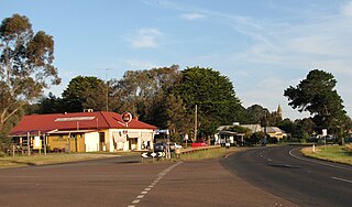
Caramut is a town in the Western District of Victoria, Australia on the Hamilton Highway. It is in the Shire of Moyne local government area and the federal Division of Wannon.
Wickliffe is a small town in the Rural City of Ararat local government area in western Victoria, Australia. At the 2016 census, Wickliffe and surrounding area had a population of 113.

Bells Creek is a mostly rural locality in the Sunshine Coast Region, Queensland, Australia. In the 2016 census, Bells Creek had a population of 94 people.

Tatyoon is a small town in the western region of Victoria. It is approximately 230 kilometres (140 mi) west of the state's capital, Melbourne. At the 2016 Census, Tatyoon had a population of 110

West Haldon is a locality split between the Lockyer Valley Region and Toowoomba Region of South East Queensland, Australia. At the 2016 Australian Census, West Haldon and surrounds recorded a population of 62. The southern boundary roughly follows the watershed of Lockyer Creek.

Ravensbourne is a locality in the Toowoomba Region local government area of Darling Downs region in southern Queensland, Australia. At the 2016 Australian Census, Ravensbourne and surrounds recorded a population of 248.

Perseverance is a locality in the Toowoomba Region local government area of Darling Downs region in southern Queensland, Australia. At the 2016 Australian Census, Perseverance recorded a population of 62.

Bessiebelle is a locality in western Victoria, Australia. The locality is in the Shire of Moyne local government area, in what is commonly known as the Western District. Besiebelle is in the County of Normanby cadastral division, approximately 311 kilometres (193 mi) west of the state capital, Melbourne, on the Eumeralla River adjacent to the Mount Eccles National Park.

Sultana Point is a locality in the Australian state of South Australia located on the Yorke Peninsula immediately adjoining the western head of Gulf St Vincent about 80 kilometres west of the state capital of Adelaide.

Narraburra is a locality in the Riverina region of New South Wales, Australia. The locality is in the Temora Shire, 431 kilometres (268 mi) west of the state capital, Sydney.

Bectric is a locality in the Riverina region of New South Wales, Australia. The locality is in the Temora Shire, 431 kilometres (268 mi) west of the state capital, Sydney.
Logie Brae is a locality in the Riverina region of New South Wales, Australia. The locality is in the Murrumbidgee Council local government area, 647 kilometres (402 mi) south west of the state capital, Sydney and 311 kilometres (193 mi) from Melbourne.
Maryborough West is a locality in the Fraser Coast Region, Queensland, Australia. At the 2016 census, it had a population of 531.