Hillston is a township in western New South Wales, Australia, in Carrathool Shire, on the banks of the Lachlan River. It was founded in 1863 and at the 2021 census had a population of 1,547.

Moyhu is a town in the Rural City of Wangaratta Local Government Area, Victoria, Australia. It is situated in the fertile King Valley, near the King River, which flows from the Victorian Alps and joins the Ovens River in Wangaratta.

East Melbourne is an inner-city suburb in Melbourne, Victoria, Australia, 2 km (1.2 mi) east of Melbourne's Central Business District, located within the City of Melbourne local government area. East Melbourne recorded a population of 4,896 at the 2021 census.
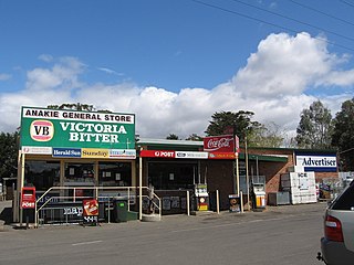
Anakie is a town between Geelong and Bacchus Marsh, in Victoria, Australia. At the 2021 census, Anakie and the surrounding area had a population of 734. The area is divided between the City of Greater Geelong and Golden Plains Shire local government areas.

Lethbridge is a town in Golden Plains Shire, Victoria, Australia. Bluestone from Lethbridge quarries was used to build several significant buildings in Melbourne, including the steps to the Parliament House. At the 2016 census, Lethbridge had a population of 1,014.

J Ward originally the Ararat County Gaol, was an Australian prison, of the latter a psychiatric facility to house the criminally insane, located in Ararat, Victoria, Australia.
Dunkeld is a town in Victoria, Australia, at the southern end of the Grampians National Park, in the Shire of Southern Grampians. It is approx 283 km west of Melbourne on the Glenelg Highway. The town's population is holding steady but aging. At the 2016 census, Dunkeld had a population of 678.

The Scots' Church is a Presbyterian church in Collins Street, Melbourne, Victoria, Australia. Services are held at 11 am (traditional) and 5pm (contemporary). It is a reformed protestant church. It was the first Presbyterian church to be built in the Port Phillip District, and serves as a congregation of the Presbyterian Church of Australia. Its building was described as "an icon for well over a hundred years".
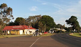
Glenthompson is a town in the Australian state of Victoria. It lies on the Glenelg Highway between Hamilton and Ballarat, close to the Grampian mountain range. At the 2016 census, Glenthompson and the surrounding area had a population of 234.

Mintaro is a historic town in the eastern Clare Valley, east of the Horrocks Highway, about 126 kilometres north of Adelaide, South Australia. The town lies at the south-eastern corner of the Hundred of Clare, within the Clare Valley wine region. Established in 1849, Mintaro is situated on land which was bought originally by Joseph and Henry Gilbert, which they sub-divided into 80 allotments.

Rosedale is a pastoral and agricultural town 184 kilometres east of Melbourne via the Princes Highway. It is situated on the southern side of the LaTrobe River. Once a staging post on the Port Albert to Sale and Port Albert to Walhalla coach runs, it was the administrative centre of the Shire of Rosedale which extended to the east and included the Ninety Mile Beach. It is now part of the Wellington Shire centred in Sale. At the 2006 census, Rosedale had a population of 1,077. The town is in the area of Gippsland explored separately by the Scotsman, Angus McMillan, and the Polish aristocrat, Count Paul von Strzelecki, in 1840. A memorial to McMillan is located in Rosedale, and one to Strzelecki near Traralgon to the west. Strzelecki named the region Gippsland after Governor Gipps.

Thomas Austin was an English settler in Australia who is generally noted for the introduction of rabbits into Australia in 1859, even though rabbits had been brought previously to Australia by the First Fleet in 1788.

Wollert is a suburb in Melbourne, Victoria, Australia, 26 km north of Melbourne's central business district, located within the City of Whittlesea local government area. Wollert recorded a population of 24,407 at the 2021 census.

Branxholme is a township in the Shire of Southern Grampians in the Western District of Victoria, Australia on the Henty Highway between Heywood and Hamilton. At the 2016 census, Branxholme and the surrounding area had a population of 351.

Macarthur originally known as Eumeralla, is a town in the Western District of Victoria, Australia on the Hamilton-Port Fairy Road. It is in the Shire of Moyne local government area and the federal Division of Wannon. At the 2016 census, Macarthur and the surrounding area had a population of 522.

Willaura is a town in western Victoria, Australia in the Rural City of Ararat local government area, 231 kilometres (144 mi) west of the state capital, Melbourne. At the 2021 census, Willaura and surrounding area had a population of 439.
Mount Sabine is a rural locality in the Shire of Colac Otway, Victoria, Australia. The small locality is located deep in the Otway Ranges, and is mostly densely forested.

Robert Francis Burns was an Irish Australian murderer and probable serial killer. He was hanged at Ararat Gaol in September 1883, convicted of the murder of Michael Quinlivan near Wickliffe in western Victoria. After Burns's death the hangman made a sensational claim that the prisoner had stated to him, prior to the execution, that he had murdered eight people in total, five in Victoria and three in New South Wales. The revelation prompted speculation in the colonial press, attempting to identify other murder victims with whom Burns had been associated.
Evander McIver was an Australian architect, engineer and surveyor. McIver is best known for a number of Gothic Revival, mostly Presbyterian churches he designed in Melbourne, Australia, during the "boom" era of the 1880s.

Dhurringile is a heritage-listed mansion and former rural estate in northern Victoria, Australia. It is listed on the Victorian Heritage Register for its architectural significance as "one of Victoria's grandest homesteads", for its associations with the Winter-Irving pastoral family, and for its later uses as an internment and prisoner of war camp, boys' training home and most recently, as part of HM Prison Dhurringile.