Related Research Articles

Saxony-Anhalt is a state of Germany, bordering the states of Brandenburg, Saxony, Thuringia and Lower Saxony. It covers an area of 20,451.7 square kilometres (7,896.4 sq mi) and has a population of 2.17 million inhabitants, making it the 8th-largest state in Germany by area and the 11th-largest by population. Its capital is Magdeburg and its largest city is Halle (Saale).

The Thuringian Forest, is a mountain range in the southern parts of the German state of Thuringia, running northwest to southeast. Skirting from its southerly source in foothills to a gorge on its north-west side is the Werra valley. On the other side of the Forest is an upper outcrop of the North German Plain, the Thuringian Basin, which includes the city Erfurt. The south and south-east continuation of the range is the highland often called the Thuringian-Vogtlandian Slate Mountains.

The Saale, also known as the Saxon Saale and Thuringian Saale, is a river in Germany and a left-bank tributary of the Elbe. It is not to be confused with the smaller Franconian Saale, a right-bank tributary of the Main, or the Saale in Lower Saxony, a tributary of the Leine.

The Ore Mountains lie along the Czech–German border, separating the historical regions of Bohemia in the Czech Republic and Saxony in Germany. The highest peaks are the Klínovec in the Czech Republic, which rises to 1,244 metres (4,081 ft) above sea level and the Fichtelberg in Germany.

The Fichtel Mountains, form a small horseshoe-shaped mountain range in northeastern Bavaria, Germany. They extend from the valley of the Red Main River to the Czech border, a few foothills spilling over into the Czech Republic. They continue in a northeasterly direction as the Elster Mountains, and in a southeasterly direction as the Upper Palatine Forest. The Fichtel Mountains contain an important nature park, the Fichtel Mountain Nature Park, with an area of 1,020 square kilometres (390 sq mi).

The Province of Saxony, also known as Prussian Saxony was a province of the Kingdom of Prussia and later the Free State of Prussia from 1816 until 1944. Its capital was Magdeburg.
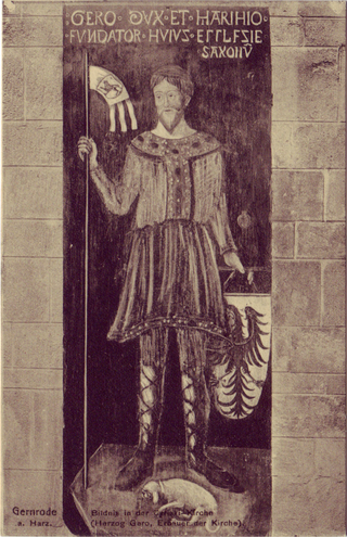
Gero I, sometimes called the Great, was a German nobleman who ruled an initially modest march centred on Merseburg in the south of the present German state of Saxony-Anhalt, which he expanded into a vast territory named after him: the marca Geronis. During the mid-10th century, he was the leader of the Saxon Ostsiedlung.
Red Croatia is a historical term used for the southeastern parts of Roman Dalmatia and some other territories, including parts of present-day Montenegro, Albania, the Herzegovina region of Bosnia and Herzegovina and southeastern Croatia, stretching along the Adriatic Sea.
In Germanic mythology, Myrkviðr is the name of several European forests.

Naumburg Cathedral, located in Naumburg, Germany, is the former cathedral of the Bishopric of Naumburg-Zeitz. The church building, most of which dates back to the 13th century, is a renowned landmark of the German late Romanesque and was recognised as a UNESCO World Heritage Site in 2018. The west choir with the famous donor portrait statues of the twelve cathedral founders (Stifterfiguren) and the Lettner, works of the Naumburg Master, is one of the most significant early Gothic monuments.
Dietrichof Haldensleben was a count in the Schwabengau, later also in the Nordthüringgau and the Derlingau, who was the first Margrave of the Northern March from 965 until the Great Slav Rising of 983. He also bore the title of a dux (duke) in contemporary sources.

Grandfontaine is a commune in the Bas-Rhin department in Grand Est in north-eastern France. In the German dialect of the region it is called Grosbrun.
Mirkwood is a name used for a great dark fictional forest in novels by Sir Walter Scott and William Morris in the 19th century, and by J. R. R. Tolkien in the 20th century. The critic Tom Shippey explains that the name evoked the excitement of the wildness of Europe's ancient North.
The Saxon Highlands and Uplands refer to a natural region mainly in the south of Saxony with small elements also in southeast Thuringia and northeast Bavaria. It comprises, from (south)west to (north)east, of the Vogtland, the Ore Mountains, Saxon Switzerland, the Upper Lusatian Plateau and the Zittau Hills.

The Thuringian Highland, Thuringian Highlands or Thuringian-Vogtlandian Slate Mountains is a low range of mountains in the German state of Thuringia.

The Leipzig Bay(German: Leipziger Tieflandsbucht) or Leipzig Basin or Saxon Lowland or Saxon Bay is a relatively lakeless and highly fertile landscape in Central Germany, in northwestern Saxony and southeastern Saxony-Anhalt.
The geography of Middle-earth encompasses the physical, political, and moral geography of J. R. R. Tolkien's fictional world of Middle-earth, strictly a continent on the planet of Arda but widely taken to mean the physical world, and Eä, all of creation, as well as all of his writings about it. Arda was created as a flat world, incorporating a Western continent, Aman, which became the home of the godlike Valar, as well as Middle-earth. At the end of the First Age, the Western part of Middle-earth, Beleriand, was drowned in the War of Wrath. In the Second Age, a large island, Númenor, was created in the Great Sea, Belegaer, between Aman and Middle-earth; it was destroyed in a cataclysm near the end of the Second Age, in which Arda was remade as a spherical world, and Aman was removed so that Men could not reach it.

Merseburg Hauptbahnhof is the main station of the town of Merseburg in the German state of Saxony-Anhalt. It is located on the Halle–Bebra railway and Deutsche Bahn assigns it to category 4. Merseburg is located in the tariff area of the Mitteldeutscher Verkehrsverbund.
The Bethenici were a West Slavic people living east of the Elbe river in the ninth century. They lived near the confluence of the Elbe and the Havel, probably between the rivers alongside the Smeldingi.
References
- ↑ mindat.org, "Miriquidite."
- ↑ M. Eggers, "Myrkviðr," Reallexikon der germanischen Altertumskunde, Vol. 20 (Walter de Gruyter, 2002: ISBN 3110171643), pp. 460-61.