
Dar es Salaam is the largest city and financial hub of Tanzania. It is also the capital of Dar es Salaam Region. With a population of over six million people, Dar es Salaam is the largest city in East Africa and the sixth-largest in Africa. Located on the Swahili coast, Dar es Salaam is an important economic centre and is one of the fastest-growing cities in the world.

Tanzania, officially the United Republic of Tanzania, is a country in East Africa within the African Great Lakes region. It borders Uganda to the north; Kenya to the northeast; the Indian Ocean to the east; Mozambique and Malawi to the south; Zambia to the southwest; and Rwanda, Burundi, and the Democratic Republic of the Congo to the west. Mount Kilimanjaro, Africa's highest mountain, is in northeastern Tanzania. According to the 2022 national census, Tanzania has a population of nearly 62 million, making it the most populous country located entirely south of the equator.

Tanzania comprises many lakes, national parks, and Africa's highest point, Mount Kilimanjaro. Northeast Tanzania is mountainous, while the central area is part of a large plateau covered in grasslands. The country also contains the southern portion of Lake Victoria on its northern border with Uganda and Kenya.
Transport in Tanzania includes road, rail, air and maritime networks. The road network is 86,472 kilometres (53,731 mi) long, of which 12,786 kilometres (7,945 mi) is classified as trunk road and 21,105 kilometres (13,114 mi) as regional road. The rail network consists of 3,682 kilometres (2,288 mi) of track. Commuter rail service is in Dar es Salaam only. There are 28 airports, with Julius Nyerere International being the largest and the busiest. Ferries connect Mainland Tanzania with the islands of Zanzibar. Several other ferries are active on the countries' rivers and lakes.

Benjamin William Mkapa was the third president of Tanzania, in office from 1995 to 2005. He was Chairman of the Revolutionary State Political Party.
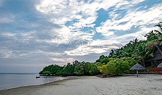
Mafia Island or Chole Shamba is an island of The Mafia Archipelago located in Mafia District in the southern Pwani Region of Tanzania across the Mafia Channel. The island is the third largest in Tanzanian ocean territory, but is not administratively included within the semi-autonomous region of Zanzibar, which has been politically separate since 1890. Mafia Island forms the largest part of Mafia District, one of the six administrative districts in the Pwani Region. As the Mafia Archipelago's main island, it's sometimes called Chole Shamba, meaning Chole farmlands in Swahili. This is in opposition to the historic settlement of Chole Mjini on Chole Island inside Mafia Bay. The island's population is over 40,000. The economy is based on fishing, subsistence agriculture and the market in Kilindoni. The island attracts some tourists, mainly scuba divers, birdwatchers, game fishermen, and people seeking relaxation.

Festus Gontebanye Mogae is a Botswana politician and economist who served as the third President of Botswana from 1998 to 2008. He succeeded Quett Masire as President in 1998 and was re-elected in October 2004; after ten years in office. He stepped down in 2008 and was succeeded by Lieutenant General Seretse Khama Ian Khama.

Mtwara Region is one of Tanzania's 31 administrative regions. The regional capital is the municipality of Mtwara. Mtwara Region is home to one of the most infuluencial people in Tanzania, the Makonde. Mtwara is home to Tanzania's 4th president Benjamin Mkapa and is home to a number of influential artists. The boundary with Mozambique to the south is formed by the Ruvuma River. To the west, Mtwara is bordered by Ruvuma Region, to the north by Lindi Region, and to the east is the Indian Ocean.
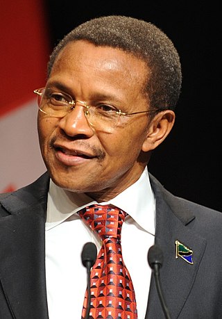
Jakaya Mrisho Kikwete is a Tanzanian politician who was the fourth president of Tanzania, in office from 2005 to 2015.

The Rufiji River lies entirely within Tanzania. It is also the largest and longest river in the country. The river is formed by the confluence of the Kilombero and Luwegu rivers. It is approximately 600 kilometres (370 mi) long, with its source in southwestern Tanzania and its mouth on the Indian Ocean opposite Mafia Island across the Mafia Channel, in Pwani Region. Its principal tributary is the Great Ruaha River. It is navigable for approximately 100 kilometres (62 mi).

Pwani Region is one of Tanzania's 31 administrative regions. The word "Pwani" in Swahili means the "coast". The regional capital is the town of Kibaha. The Region borders the Tanga Region to the north, Morogoro Region to the west, Lindi Region to the south, and surrounds Dar es Salaam Region to the east. The Indian Ocean also borders the region to its northeast and southeast. The region is home to Mafia Island, the Rufiji delta and Saadani National Park. The region is home to Bagamoyo town, a historical Swahili settlement, and the first colonial capital of German East Africa. According to the 2012 national census, the region had a population of 1,098,668, which was slightly lower than the pre-census projection of 1,110,917. From 2002 to 2012, the region's 2.2 percent average annual population growth rate was the seventeenth-highest in the country. It was also the 21st most densely populated region with 34 people per square kilometre., the region is slightly larger than Belgium.

The Selous Game Reserve, now renamed as Nyerere National Park, is a protected area in southern Tanzania. It covers a total area of 50,000 km2 (19,000 sq mi) and has additional buffer zones. It was designated a UNESCO World Heritage Site in 1982 due to its wildlife diversity and undisturbed nature. Some of the diverse wildlife of the Miombo include the African bush elephant, south-central black rhinoceros, hippopotamus, lion, African wild dog, African buffalo, Masai giraffe, plains zebra and Nile crocodile. Permanent human habitation is not permitted within the reserve. All human entry and exit is controlled by the Wildlife Division of the Tanzanian Ministry of Natural Resources and Tourism.

Kisarawe District Council is one of eight administrative districts of Pwani Region in Tanzania. The District covers an area of 5,031 km2 (1,942 sq mi). It is bordered to the east by Dar es Salaam Region's Ilala and Ubungo Municipal Councils. The Kibaha District and Kibaha Town Council border the district to the north, and the Mkuranga District and Kibiti District border it to the south-east. By the Rufiji District to the south, and the Morogoro District of the Morogoro Region to the west. The district is comparable in size to the land area of Trinidad and Tobago. The town of Kisarawe serves as its administrative capital. According to the 2012 Tanzania National Census, the population of the District was 101,598.

Tanzania National Main Stadium also known as Benjamin Mkapa Stadium is a multi-purpose stadium located in Miburani ward of Temeke District in Dar es Salaam, Tanzania. It opened in 2007 and was built adjacent to Uhuru Stadium, the former national stadium. It hosts major football matches such as the Tanzanian Premier League and home matches of the Tanzania national football team.

Kitulo National Park is a protected area of montane grassland and montane forest on the Kitulo Plateau in the southern highlands of Tanzania. The park is at an elevation of 2,600 metres (8,500 ft) between the peaks of the Kipengere and Poroto mountains and covers an area of 412.9 square kilometres (159.4 sq mi), lying in Mbeya Region and Njombe Region. The park is administered by Tanzania National Parks (TANAPA) and is the first national park in tropical Africa to be established primarily to protect its flora.
This is a timeline of Tanzanian history, comprising important legal and territorial changes and political events in Tanzania and its predecessor states. To read about the background to these events, see History of Tanzania. See also the list of presidents of Tanzania.
The 2012 Kagame Interclub Cup was the 37th edition of the Kagame Interclub Cup, which is organised by CECAFA. It began on 14 July and ended on 28 July 2012. Tanzania hosted the tournament for their eleventh time since it officially began in 1974, when they were also hosts. The tournament made Wau Salaam the first South Sudanese club to take part in an international club tournament.
Julius Nyerere Hydropower Station is a hydroelectric dam under construction across the Rufiji River in eastern Tanzania. Although controversial, the government approved the plans in 2018. The power station is expected to have an installed capacity of 2,115 megawatts (2,836,000 hp) and to produce 5,920GWh of power annually. The project, power station and dam are owned by and will be managed by the government owned Tanzania Electric Supply Company (TANESCO). Construction began in 2019 and is expected to be completed in 2024.

At least 30 tropical cyclones have affected the Southern African mainland. Three southeastern African countries border the Indian Ocean – Tanzania, Mozambique, and South Africa. Other inland countries also experience the effects of tropical cyclones, including Botswana, Eswatini, Lesotho, Malawi, Namibia, Zambia, and Zimbabwe.

Egypt–Tanzania relations are bilateral relations between Egypt and Tanzania. The two nations primarily maintain trade ties and established formal diplomatic relations in 1964.

