Transport in Tanzania includes road, rail, air and maritime networks. The road network is 86,472 kilometres (53,731 mi) long, of which 12,786 kilometres (7,945 mi) is classified as trunk road and 21,105 kilometres (13,114 mi) as regional road. The rail network consists of 3,682 kilometres (2,288 mi) of track. Commuter rail service is in Dar es Salaam only. There are 28 airports, with Julius Nyerere International being the largest and the busiest. Ferries connect Mainland Tanzania with the islands of Zanzibar. Several other ferries are active on the countries' rivers and lakes.

The Tazara Railway, also called the Uhuru Railway or the Tanzam Railway, is a railway in East Africa linking the port of Dar es Salaam in east Tanzania with the town of Kapiri Mposhi in Zambia's Central Province. The single-track railway is 1,860 km (1,160 mi) long and is operated by the Tanzania-Zambia Railway Authority (TAZARA).

Lira is a city in the Northern Region of Uganda. It is the main municipal, administrative, and commercial centre of Lira District.
Kyaka is a town in Tanzania. It is an urban centre in Missenyi District, Kagera Region. The population of Kyaka was estimated at 6,000 people in 2015.
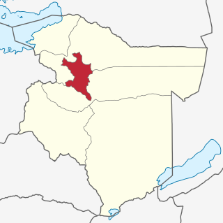
Morogoro Region is one of Tanzania's 31 administrative regions. The region covers an area of 70,624 km2 (27,268 sq mi). The region is comparable in size to the combined land area of the nation state of Ireland. Morogoro Region is bordered to the north by the Manyara Region and Tanga Region, to the east by the Pwani and Lindi Regions, to the south by the Ruvuma Region and to the west by the Iringa Njombe and Dodoma Regions. The regional capital is the municipality of Morogoro. According to the 2022 national census, the region had a population of 3,197,104.
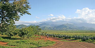
Ifakara is a town in the Kilombero District, Morogoro Region, south central Tanzania. It is the headquarters of the Kilombero District administration and the main trading centre for Kilombero and Ulanga districts. The town is located near the Tanzania-Zambia Railway (TAZARA) line, at the edge of the Kilombero Valley, a vast swampland flooded by the mighty Kilombero River.
Bugamba is an urban centre in the Western Region of Uganda. It is one of the trading centres in Mbarara District.
Kanungu is a town in the Western Region of Uganda. It is the location of the district headquarters for Kanungu District.
Kayunga is a town in the Central Region of Uganda. It is the main municipal, administrative, and commercial center of Kayunga District.
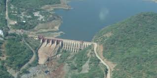
Kidatu Dam, also Kidadu Hydroelectric Power Station, is a 204 megawatts (274,000 hp) hydroelectric dam located in Kilosa District of Morogoro Region in Tanzania.
Kihansi Hydroelectric Power Station, is a 180 megawatts (241,384 hp) hydroelectric power station located in Kilombero District of southeast Morogoro Region in southern Tanzania. The power station is one of the largest dams in the country. The Tanzanian electricity company, Tanesco operates the power station on behalf of the government of Tanzania.
Kidatu is a town in central Tanzania, located in Kilombero District, Morogoro Region. The local population is about 3,300. The primary economic activity is the large Illovo sugar cane plantation and factory which produces 130,000 tonnes of sugar per year.
Bukomansimbi is a town in the Central Region of Uganda. It is the chief municipal, administrative, and commercial center of Bukomansimbi District and the site of the district headquarters.
The Rusumo Hydroelectric Power Station, also known as the Rusumo Power Station, is a hydropower plant under construction, with initial planned capacity installation of 80 megawatts (110,000 hp) when completed. The project will involve the construction of a dam, with run of river design. A more expensive 90 megawatts (120,000 hp) reservoir design was considered before being abandoned in favor of an 80 MW project with a smaller environmental impact and an estimated cost of US$300 million compared to US$400 million for the bigger project. The World Bank announced on 6 August 2013 that it had approved loans totaling US$340 million towards the US$468.60 million needed for the project. In November 2013, the African Development Bank approved a loan of US$113 million towards completion of the project.
Bariadi is a Tanzanian town and regional capital of Simiyu Region, and the is also administrative seat of Bariadi District. Bariadi also refers to Bariadi Ward, another administrative unit in the district.
Bukomero is a town in Ssingo County, Kiboga District, in the Central Region of Uganda.
Nakonde is a town in the Muchinga Province of Zambia, on the border with Tanzania. It is at the northern end of Zambia's Great North Road. It is the principal commercial and political headquarters of Nakonde District and the district headquarters are located here.

Malinyi District is a district of the Morogoro Region of Tanzania.
Nyapea, is a town in Zombo District, West Nile sub-region, in the Northern Region of Uganda.
The Mirama–Kikagati–Nsongezi High Voltage Power Line is a planned high voltage electricity power line, connecting the high voltage substation at Mirama Hills, in the Western Region of Uganda, to another high voltage substation at Kikagati Hydroelectric Power Station and continues to end at Nshungyezi Hydropower Station.
