Moanatuatua Scientific Reserve

Last updated
Moanatuatua Scientific Reserve
Moanatuatua.tif
From the center of the reserve looking out to Pirongia Mountain
Location North Island, New Zealand
Nearest city Hamilton, New Zealand
Coordinates 37°55′30″S175°22′08″E / 37.925°S 175.369°E / -37.925; 175.369 Coordinates: 37°55′30″S175°22′08″E / 37.925°S 175.369°E / -37.925; 175.369
Area140 hectares (350 acres)

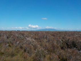
Moanatuatua scientific reserve is a 140 ha remnant of restiad (Restionaceae) peatland in the North Island of New Zealand. The bog was formerly ~ 7500 ha in size and was one of several large peatlands surrounding the city of Hamilton. Widespread drainage and conversion to agriculture has left only this small remnant of what was formerly the dominant ecosystem in the area. [1]

Contents

Moanatuatua is the best studied peatland in New Zealand, with research commencing in 1917 [2] and at least 40 separate investigations during the next 100 years. The site is of international interest with research being carried out by scientists based in the UK and Canada as well as locally in New Zealand. The peat contains well-preserved pollen grains and plant remains dating back 14,000 years, making the site an important palaeoclimatic record for New Zealand and the south pacific. [3]

Conservation value

Moanatuatua is one of the only three known sites to contain the rare rush-like plant Sporadanthus ferrugineus [4] and the endemic moth Houdinia flexilissima known as 'Fred the thread', claimed to be the thinnest caterpillar in the world. [5] The bog is also an important regional habitat for the native Fernbird and provides habitat for Swamp harriers which may in turn help minimise crop losses from nearby blueberry farms. Other vegetation at the site includes the fern Gleichenia dicarpa and the plant Empodisma robustum . [1]

History of Moanatuatua bog

Moanatuatua bog was taken in 1863 from the traditional Kaitiaki during the New Zealand Wars under the New Zealand settlement act. [6] The bog was surveyed in 1868 by Edwin Davey with the peat depth being measured every 10 feet, [7] though unfortunately the map has since been lost. The land was then sold to James Farmer of Epsom who sold it on to the absentee landowner Thomas Grice of Cumberland. [6] The bog was managed by Barnes Walker and Thomas Douglas, who independently acquired tracts of land surrounding the bog. [6] Walker is believed to have played a prominent part in early attempts to drain the bog and was instrumental in digging the main central drain in the summer of 1869-1870. [6] The drain was commented on by the geologist Laurence Cussen in 1893 as the outflow had recently eroded a gully 70ft deep where it flowed into the Waikato river. [8] During the time the drain was being dug the settlers came into conflict with local Māori when they attempted to drain land south of the Aukati or confiscation line, [9] a farm worker, Timothy Sullivan was killed in the ensuing conflict. [10] By 1888, 800 ha had been converted to pastoral land and 225 km of drains had been dug, [6] Despite this, the land owners found themselves in financial trouble and sold the eastern part of the bog to the New Zealand government in 1893. [6] The government re-sold 560 ha of the bog to Richard Reynolds [6] [11] who described his approach to converting the bog to pasture in the following terms: “You cannot burn a peat swamp too deep, dry it as fast as possible and burn it as much as possible”. [12]

Research carried out at Moanatuatua bog

During the late 19th century observations of the plants at Moanatuatua were carried out by the botanist Thomas Frederic Cheeseman. However research at Moanatuatua peatland did not begin in earnest until 1917 with the early investigations of the peat by Bernard Cracroft Aston. [2] During the 1930s the peat depth, surface contours [13] and vegetation [14] were studied and the site was described by the botanist Lucy Cranwell. In the 1950s and 1960s further botanical work was carried out by Ella Orr Campbell. In 1946 the Rukuhia Soil Fertility Research Station was set up with the main objective of carrying out practical investigations into farming the surrounding peatland, however some limited research was also performed on the natural peat ecosystem including chemical [15] and nutrient analysis prior to water table lowering. Since 2010 research at Moanatuatua bog has been focused on the effect of lower water tables on plants, nutrient cycling, carbon storage [16] and palaeoclimatic reconstructions. [3] [17]

See also

Related Research Articles

<span class="mw-page-title-main">Swamp</span> A forested wetland

A swamp is a forested wetland. Swamps are considered to be transition zones because both land and water play a role in creating this environment. Swamps vary in size and are located all around the world. The water of a swamp may be fresh water, brackish water, or seawater. Freshwater swamps form along large rivers or lakes where they are critically dependent upon rainwater and seasonal flooding to maintain natural water level fluctuations. Saltwater swamps are found along tropical and subtropical coastlines. Some swamps have hammocks, or dry-land protrusions, covered by aquatic vegetation, or vegetation that tolerates periodic inundation or soil saturation. The two main types of swamp are "true" or swamp forests and "transitional" or shrub swamps. In the boreal regions of Canada, the word swamp is colloquially used for what is more formally termed a bog, fen, or muskeg. Some of the world's largest swamps are found along major rivers such as the Amazon, the Mississippi, and the Congo.

<span class="mw-page-title-main">Peat</span> Accumulation of partially decayed vegetation

Peat, also known as turf, is an accumulation of partially decayed vegetation or organic matter. It is unique to natural areas called peatlands, bogs, mires, moors, or muskegs. The peatland ecosystem covers 3.7 million square kilometres (1.4 million square miles) and is the most efficient carbon sink on the planet, because peatland plants capture carbon dioxide (CO2) naturally released from the peat, maintaining an equilibrium. In natural peatlands, the "annual rate of biomass production is greater than the rate of decomposition", but it takes "thousands of years for peatlands to develop the deposits of 1.5 to 2.3 m [4.9 to 7.5 ft], which is the average depth of the boreal [northern] peatlands", which store around 415 gigatonnes (Gt) of carbon (about 46 times 2019 global CO2 emissions). Globally, peat stores up to 550 Gt of carbon, 42% of all soil carbon, which exceeds the carbon stored in all other vegetation types, including the world's forests, although it covers just 3% of the land's surface. Sphagnum moss, also called peat moss, is one of the most common components in peat, although many other plants can contribute. The biological features of sphagnum mosses act to create a habitat aiding peat formation, a phenomenon termed 'habitat manipulation'. Soils consisting primarily of peat are known as histosols. Peat forms in wetland conditions, where flooding or stagnant water obstructs the flow of oxygen from the atmosphere, slowing the rate of decomposition. Peat properties such as organic matter content and saturated hydraulic conductivity can exhibit high spatial heterogeneity.

<span class="mw-page-title-main">Fen</span> Type of wetland fed by mineral-rich ground or surface water

A fen is a type of peat-accumulating wetland fed by mineral-rich ground or surface water. It is one of the main types of wetlands along with marshes, swamps, and bogs. Bogs and fens, both peat-forming ecosystems, are also known as mires. The unique water chemistry of fens is a result of the ground or surface water input. Typically, this input results in higher mineral concentrations and a more basic pH than found in bogs. As peat accumulates in a fen, groundwater input can be reduced or cut off, making the fen ombrotrophic rather than minerotrophic. In this way, fens can become more acidic and transition to bogs over time.

<span class="mw-page-title-main">Bog</span> Type of wetland that accumulates peat due to incomplete decomposition of plant matter

A bog or bogland is a wetland that accumulates peat as a deposit of dead plant materials – often mosses, typically sphagnum moss. It is one of the four main types of wetlands. Other names for bogs include mire, mosses, quagmire, and muskeg; alkaline mires are called fens. A baygall is another type of bog found in the forest of the Gulf Coast states in the United States. They are often covered in heath or heather shrubs rooted in the sphagnum moss and peat. The gradual accumulation of decayed plant material in a bog functions as a carbon sink.

<i>Sphagnum</i> Genus of mosses, peat moss

Sphagnum is a genus of approximately 380 accepted species of mosses, commonly known as sphagnum moss, peat moss, also bog moss and quacker moss. Accumulations of Sphagnum can store water, since both living and dead plants can hold large quantities of water inside their cells; plants may hold 16 to 26 times as much water as their dry weight, depending on the species. The empty cells help retain water in drier conditions.

<span class="mw-page-title-main">Peat swamp forest</span> Tropical moist forests where waterlogged soil prevents dead leaves and wood from fully decomposing

Peat swamp forests are tropical moist forests where waterlogged soil prevents dead leaves and wood from fully decomposing. Over time, this creates a thick layer of acidic peat. Large areas of these forests are being logged at high rates.

<span class="mw-page-title-main">Borneo peat swamp forests</span> Ecoregion in Borneo

The Borneo peat swamp forests ecoregion, within the tropical and subtropical moist broadleaf forests biome, are on the island of Borneo, which is divided between Brunei, Indonesia and Malaysia.

<span class="mw-page-title-main">Kopuatai Peat Dome</span>

The Kopuatai Peat Dome is a large peatland complex on the Hauraki Plains in the North Island of New Zealand. It consists of two raised domes, one in the north and the other in the south, that are up to three metres higher at the center than at the edge. The 10,201 hectares wetland contains the largest intact raised bog in New Zealand and was listed under the Ramsar Convention in 1989 as a Wetland of International Importance. Most of the wetland is ombrotrophic, meaning it receives water and nutrient inputs solely from rain and is hydrologically isolated from the surrounding canals and rivers. Locally, a popular misconception persists that water flows from the nearby Piako River into the bog and that the wetland acts as a significant store for floodwater.

The Whangamarino River is a lowland river of the Waikato Region of New Zealand's North Island, draining the Whangamarino Wetland and associated farmland catchment. The river converges with the Waikato River just north of Meremere. The main tributary is the Maramarua River, which starts in the Hunua Ranges and forms the northern catchment of the Whangamarino River.

<i>Empodisma minus</i> Species of flowering plant

Empodisma minus, commonly known as (lesser) wire rush or spreading rope-rush, is a perennial evergreen belonging to the southern-hemisphere family of monocotyledons called the Restionaceae. The Latin name Empodisma minus translates to “tangle-foot” “small”. E. minus is found from Queensland to South Australia, Tasmania and throughout New Zealand south of 38 ° latitude, or the central north island. Its current conservation status is “Least concerned”. In 2012 the new species Empodisma robustum was described in New Zealand, with what was previously described as E. minus from the lowland raised bogs of Waikato and Northland now being re-classified as E. robustum. E. minus remains an important peatformer in the south of New Zealand and in high altitude peatlands.

Houdinia is a monotypic genus of moths in the family Batrachedridae. Its sole species, Houdinia flexilissima, is endemic to raised bogs in northern New Zealand. It is classified as "At Risk, Relict" by the Department of Conservation. The caterpillars are sometimes referred to as Fred the thread.

<span class="mw-page-title-main">Whangamarino Wetland</span> Wetland of international importance under the Ramsar Convention

The Whangamarino Wetland in the Waikato District is the second largest wetland complex of the North Island of New Zealand. Encompassing a total area of more than 7200 hectares, the Department of Conservation Te Papa Atawhai manages 5,923 hectares of peat bog, swamp, mesotrophic lags, open water and river systems listed as a wetland of international importance under the Ramsar Convention. Fish and Game New Zealand are the second largest landowner, managing 748 hectares of the wetland primarily as gamebird hunting habitat.

<i>Sporadanthus ferrugineus</i> Species of flowering plant

Sporadanthus ferrugineus, the bamboo rush or giant wire rush, is a restiad plant endemic to the northern North Island of New Zealand.

<span class="mw-page-title-main">Mire</span> Wetland terrain without forest cover, dominated by living, peat-forming plants

A mire, peatland, or quagmire is a wetland area dominated by living peat-forming plants. Mires arise because of incomplete decomposition of organic matter, usually litter from vegetation, due to water-logging and subsequent anoxia. All types of mires share the common characteristic of being saturated with water, at least seasonally with actively forming peat, while having their own ecosystem. Like coral reefs, mires are unusual landforms that derive mostly from biological rather than physical processes, and can take on characteristic shapes and surface patterning.

Paludiculture is wet agriculture and forestry on peatlands. Paludiculture combines the reduction of greenhouse gas emissions from drained peatlands through rewetting with continued land use and biomass production under wet conditions. “Paludi” comes from the Latin “palus” meaning “swamp, morass” and "paludiculture" as a concept was developed at Greifswald University. Paludiculture is a sustainable alternative to drainage-based agriculture, intended to maintain carbon storage in peatlands. This differentiates paludiculture from agriculture like rice paddies, which involve draining, and therefore degrading wetlands.

<i>Corybas carsei</i> Species of orchid

Corybas carsei, commonly known as the swamp helmet orchid, is a species of terrestrial orchid endemic to New Zealand. It is found only in Whangamarino Wetland in the Waikato District, where the population of fewer than 250 plants is critically endangered.

Lake Opuatia is a small lake in the much larger Opuatia wetland, which drains from the west into the Waikato River. It lies near the foot of a long valley drained by the Opuatia Stream.

Empodisma gracillimum is a species of sedge-like plant endemic to coastal areas of Southwest Australia. Described within an Australian and New Zealand genus of the rush- or bamboo-like Restionaceae family, it is the only species of Empodisma to be found in Western Australia.

Rukuhia is a rural community in the Waipa District and Waikato region of New Zealand's North Island.

Beverley Rae Clarkson is a New Zealand botanist, ecologist and wetland researcher and conservationist. She is best known for her research into and her conservation work with New Zealand wetlands. In 2021, the city of Hamilton awarded her the Hamilton-Kirikiroa Medal. In the same year Clarkson was awarded the New Zealand conservation award, the Loder Cup.

References

  1. 1 2 Clarkson, Beverley R.; Schipper, Louis A.; Lehmann, Anthony (2004). "Vegetation and peat characteristics in the development of lowland restiad peat bogs, North Island, New Zealand". Wetlands. 24 (1): 133–151. doi:10.1672/0277-5212(2004)024[0133:vapcit]2.0.co;2. ISSN   0277-5212.
  2. 1 2 Aston, B.C (1917). "The Burning of Peaty Swamps". The New Zealand Journal of Agriculture. 15: 10–15.
  3. 1 2 Jara, Ignacio A; Newnham, Rewi M; Alloway, Brent V; Wilmshurst, Janet M; Rees, Andrew BH (2017). "Pollen-based temperature and precipitation records of the past 14,600 years in northern New Zealand (37°S) and their linkages with the Southern Hemisphere atmospheric circulation". The Holocene. 27 (11): 1756–1768. Bibcode:2017Holoc..27.1756J. doi:10.1177/0959683617708444. ISSN   0959-6836. S2CID   133683042.
  4. de Lange, P. J.; Heenan, P. B.; Clarkson, B. D.; Clarkson, B. R. (1999). "Taxonomy, ecology, and conservation of Sporadanthus (Restionaceae) in New Zealand". New Zealand Journal of Botany. 37 (3): 413–431. doi:10.1080/0028825x.1999.9512645. ISSN   0028-825X.
  5. Hoare, Robert; Dugdale, John; Watts, Corinne (2006-11-02). "The world's thinnest caterpillar? A new genus and species of Batrachedridae (Lepidoptera) from Sporadanthus ferrugineus (Restionaceae), a threatened New Zealand plant". Invertebrate Systematics. 20 (5): 571–583. doi:10.1071/is06009. ISSN   1447-2600 via Researchgate.
  6. 1 2 3 4 5 6 7 Mandeno, J. F. (2001). "The Waipa Swamps - Moana-tua-tua and Rukuhia". Footprints of History. 26: 4–7.
  7. Eric., Beer (1975). Plough of the pakeha. Cambridge Independent. OCLC   154652922.
  8. Cussen, Laurence (1893). "Notes on the Piako and Waikato River-basins". Transactions and Proceedings of the NZ Institute. 26: 398–407.
  9. "Confiscation of Māori land".
  10. "STORY OF PARAKAIA TE KORAU IN REFERENCE TO THE MOANATUATUA MURDER". DAILY SOUTHERN CROSS. Vol. XXIX, no. 4894. 1873.
  11. "Richard Chidley Reynolds".
  12. Reynolds, Richard (1917). "Development of Peat Swamps". The NEw Zealand Journal of Agriculture. 15: 9–10.
  13. Grange, LI, Taylor NH, Sutherland, CF (1939). Soils and Agriculture of Part of Waipa Count. Wellington: Government Printer.{{cite book}}: CS1 maint: multiple names: authors list (link)
  14. Cranwell, LM (1939). Native Vegetation. In: The soils and Agriculture of Part of Waipa County. Wellington: Government Printer. pp. 23–29.
  15. Bailey, R.W (1953). "Composition of the Organic Fraction of the Waikato and Hauraki Peats". New Zealand Journal of Science and Technology. 53: 421–431.
  16. Ratcliffe, Joshua L.; Campbell, David I.; Clarkson, Beverley R.; Wall, Aaron M.; Schipper, Louis A. (March 2019). "Water table fluctuations control CO2 exchange in wet and dry bogs through different mechanisms". Science of the Total Environment. 655: 1037–1046. Bibcode:2019ScTEn.655.1037R. doi:10.1016/j.scitotenv.2018.11.151. ISSN   0048-9697. PMID   30577098.
  17. T., Roland; J., Amesbury, M.; D., Charman; R., Newnham; J., Royles; H., Griffiths; J., Ratcliffe; A., Rees; D., Campbell (December 2017). "Developing novel peat isotope proxies from vascular plant-dominated peatlands of New Zealand to reconstruct Southern Hemisphere climate dynamics". AGU Fall Meeting Abstracts. 2017: 43B–1356. Bibcode:2017AGUFMPP43B1356R.