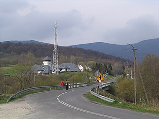
Ustrzyki Górne is a village in the administrative district of Gmina Lutowiska, within Bieszczady County, Subcarpathian Voivodeship, in south-eastern Poland, close to the border with Ukraine. It lies approximately 17 kilometres (11 mi) south of Lutowiska, 37 km (23 mi) south of Ustrzyki Dolne, and 114 km (71 mi) south-east of the regional capital Rzeszów.

Arłamów is a village in the administrative district of Gmina Ustrzyki Dolne, within Bieszczady County, Subcarpathian Voivodeship, in south-eastern Poland, near the border with Ukraine. It lies approximately 18 kilometres (11 mi) north of Ustrzyki Dolne and 69 km (43 mi) south-east of the regional capital Rzeszów.
Bandrów Narodowy is a village in the administrative district of Gmina Ustrzyki Dolne, within Bieszczady County, Subcarpathian Voivodeship, in south-eastern Poland, near the border with Ukraine. It lies approximately 9 kilometres (6 mi) south-east of Ustrzyki Dolne and 87 km (54 mi) south-east of the regional capital Rzeszów.

Brzegi Dolne is a village in the administrative district of Gmina Ustrzyki Dolne, within Bieszczady County, Subcarpathian Voivodeship, in south-eastern Poland. It lies approximately 3 kilometres (2 mi) north-east of Ustrzyki Dolne and 79 km (49 mi) south-east of the regional capital Rzeszów.
Jałowe is a village in the administrative district of Gmina Ustrzyki Dolne, within Bieszczady County, Subcarpathian Voivodeship, in south-eastern Poland, near the border with Ukraine. It lies approximately 6 kilometres (4 mi) east of Ustrzyki Dolne and 84 km (52 mi) south-east of the regional capital Rzeszów.

Jureczkowa is a village in the administrative district of Gmina Ustrzyki Dolne, within Bieszczady County, Subcarpathian Voivodeship, in south-eastern Poland, near the border with Ukraine. It lies approximately 12 kilometres (7 mi) north of Ustrzyki Dolne and 70 km (43 mi) south-east of the regional capital Rzeszów.

Krościenko is a village in the administrative district of Gmina Ustrzyki Dolne, within Bieszczady County, Subcarpathian Voivodeship, in south-eastern Poland, near the border with Ukraine. It lies approximately 7 kilometres (4 mi) north-east of Ustrzyki Dolne and 79 km (49 mi) south-east of the regional capital Rzeszów.
Kwaszenina is a village in the administrative district of Gmina Ustrzyki Dolne, within Bieszczady County, Subcarpathian Voivodeship, in south-eastern Poland, near the border with Ukraine. It lies approximately 14 kilometres (9 mi) north of Ustrzyki Dolne and 72 km (45 mi) south-east of the regional capital Rzeszów.

Liskowate is a village in the administrative district of Gmina Ustrzyki Dolne, within Bieszczady County, in the Subcarpathian Voivodeship of south-eastern Poland, near the border with Ukraine. It lies approximately 10 kilometres (6 mi) north of Ustrzyki Dolne and 73 km (45 mi) south-east of the regional capital Rzeszów.
Łobozew Dolny is a village in the administrative district of Gmina Ustrzyki Dolne, within Bieszczady County, Subcarpathian Voivodeship, in south-eastern Poland. It lies approximately 10 kilometres (6 mi) south-west of Ustrzyki Dolne and 79 km (49 mi) south-east of the regional capital Rzeszów.

Łodyna is a village in the administrative district of Gmina Ustrzyki Dolne, within Bieszczady County, Subcarpathian Voivodeship, in south-eastern Poland. It lies approximately 4 kilometres (2 mi) north of Ustrzyki Dolne and 76 km (47 mi) south-east of the regional capital Rzeszów.
Równia is a village in the administrative district of Gmina Ustrzyki Dolne, within Bieszczady County, Subcarpathian Voivodeship, in south-eastern Poland. It lies approximately 2 kilometres (1 mi) south of Ustrzyki Dolne and 81 km (50 mi) south-east of the regional capital Rzeszów.
Serednica is a village in the administrative district of Gmina Ustrzyki Dolne, within Bieszczady County, Subcarpathian Voivodeship, in south-eastern Poland. It lies approximately 10 kilometres (6 mi) north-west of Ustrzyki Dolne and 70 km (43 mi) south-east of the regional capital Rzeszów.

Stańkowa is a village in the administrative district of Gmina Ustrzyki Dolne, within Bieszczady County, Subcarpathian Voivodeship, in south-eastern Poland. It lies approximately 18 kilometres (11 mi) north-west of Ustrzyki Dolne and 62 km (39 mi) south-east of the regional capital Rzeszów.
Teleśnica Oszwarowa is a village in the administrative district of Gmina Ustrzyki Dolne, within Bieszczady County, Subcarpathian Voivodeship, in south-eastern Poland. It lies approximately 7 kilometres (4 mi) south-west of Ustrzyki Dolne and 83 km (52 mi) south-east of the regional capital Rzeszów.
Ustjanowa Dolna is a village in the administrative district of Gmina Ustrzyki Dolne, within Bieszczady County, Subcarpathian Voivodeship, in south-eastern Poland. It lies approximately 8 kilometres (5 mi) west of Ustrzyki Dolne and 78 km (48 mi) south-east of the regional capital Rzeszów.

Ustjanowa Górna is a village in the administrative district of Gmina Ustrzyki Dolne, within Bieszczady County, Subcarpathian Voivodeship, in south-eastern Poland. It lies approximately 6 kilometres (4 mi) west of Ustrzyki Dolne and 79 km (49 mi) south-east of the regional capital Rzeszów.
Wojtkowa is a village in the administrative district of Gmina Ustrzyki Dolne, within Bieszczady County, Subcarpathian Voivodeship, in south-eastern Poland. It lies approximately 15 kilometres (9 mi) north of Ustrzyki Dolne and 66 km (41 mi) south-east of the regional capital Rzeszów.
Wola Romanowa is a village in the administrative district of Gmina Ustrzyki Dolne, within Bieszczady County, Subcarpathian Voivodeship, in south-eastern Poland. It lies approximately 8 kilometres (5 mi) north-west of Ustrzyki Dolne and 73 km (45 mi) south-east of the regional capital Rzeszów.
Zadwórze is a village in the administrative district of Gmina Ustrzyki Dolne, within Bieszczady County, Subcarpathian Voivodeship, in south-eastern Poland. It lies approximately 7 kilometres (4 mi) south-east of Ustrzyki Dolne and 87 km (54 mi) south-east of the regional capital Rzeszów.


