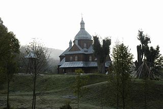
Hoszów is a village in the administrative district of Gmina Ustrzyki Dolne, within Bieszczady County, Subcarpathian Voivodeship, in south-eastern Poland. It lies approximately 6 kilometres (4 mi) south-east of Ustrzyki Dolne and 85 km (53 mi) south-east of the regional capital Rzeszów.

Arłamów is a village in the administrative district of Gmina Ustrzyki Dolne, within Bieszczady County, Subcarpathian Voivodeship, in south-eastern Poland, near the border with Ukraine. It lies approximately 18 kilometres (11 mi) north of Ustrzyki Dolne and 69 km (43 mi) south-east of the regional capital Rzeszów.
Bandrów Narodowy is a village in the administrative district of Gmina Ustrzyki Dolne, within Bieszczady County, Subcarpathian Voivodeship, in south-eastern Poland, near the border with Ukraine. It lies approximately 9 kilometres (6 mi) south-east of Ustrzyki Dolne and 87 km (54 mi) south-east of the regional capital Rzeszów.

Brelików is a village in the administrative district of Gmina Ustrzyki Dolne, within Bieszczady County, Subcarpathian Voivodeship, in south-eastern Poland. It lies approximately 12 kilometres (7 mi) north-west of Ustrzyki Dolne and 69 km (43 mi) south-east of the regional capital Rzeszów.

Brzegi Dolne is a village in the administrative district of Gmina Ustrzyki Dolne, within Bieszczady County, Subcarpathian Voivodeship, in south-eastern Poland. It lies approximately 3 kilometres (2 mi) north-east of Ustrzyki Dolne and 79 km (49 mi) south-east of the regional capital Rzeszów.
Jureczkowa is a village in the administrative district of Gmina Ustrzyki Dolne, within Bieszczady County, Subcarpathian Voivodeship, in south-eastern Poland, near the border with Ukraine. It lies approximately 12 kilometres (7 mi) north of Ustrzyki Dolne and 70 km (43 mi) south-east of the regional capital Rzeszów.
Leszczowate is a village in the administrative district of Gmina Ustrzyki Dolne, within Bieszczady County, Subcarpathian Voivodeship, in south-eastern Poland. It lies approximately 8 kilometres (5 mi) north of Ustrzyki Dolne and 72 km (45 mi) south-east of the regional capital Rzeszów.
Łobozew Dolny is a village in the administrative district of Gmina Ustrzyki Dolne, within Bieszczady County, Subcarpathian Voivodeship, in south-eastern Poland. It lies approximately 10 kilometres (6 mi) south-west of Ustrzyki Dolne and 79 km (49 mi) south-east of the regional capital Rzeszów.
Łobozew Górny is a village in the administrative district of Gmina Ustrzyki Dolne, within Bieszczady County, Subcarpathian Voivodeship, in south-eastern Poland. It lies approximately 9 kilometres (6 mi) south-west of Ustrzyki Dolne and 82 km (51 mi) south-east of the regional capital Rzeszów.

Łodyna is a village in the administrative district of Gmina Ustrzyki Dolne, within Bieszczady County, Subcarpathian Voivodeship, in south-eastern Poland. It lies approximately 4 kilometres (2 mi) north of Ustrzyki Dolne and 76 km (47 mi) south-east of the regional capital Rzeszów.
Ropienka is a village in the administrative district of Gmina Ustrzyki Dolne, within Bieszczady County, Subcarpathian Voivodeship, in south-eastern Poland. It lies approximately 13 kilometres (8 mi) north-west of Ustrzyki Dolne and 67 km (42 mi) south-east of the regional capital Rzeszów.
Równia is a village in the administrative district of Gmina Ustrzyki Dolne, within Bieszczady County, Subcarpathian Voivodeship, in south-eastern Poland. It lies approximately 2 kilometres (1 mi) south of Ustrzyki Dolne and 81 km (50 mi) south-east of the regional capital Rzeszów.

Stańkowa is a village in the administrative district of Gmina Ustrzyki Dolne, within Bieszczady County, Subcarpathian Voivodeship, in south-eastern Poland. It lies approximately 18 kilometres (11 mi) north-west of Ustrzyki Dolne and 62 km (39 mi) south-east of the regional capital Rzeszów.
Teleśnica Oszwarowa is a village in the administrative district of Gmina Ustrzyki Dolne, within Bieszczady County, Subcarpathian Voivodeship, in south-eastern Poland. It lies approximately 7 kilometres (4 mi) south-west of Ustrzyki Dolne and 83 km (52 mi) south-east of the regional capital Rzeszów.
Trzcianiec is a village in the administrative district of Gmina Ustrzyki Dolne, within Bieszczady County, Subcarpathian Voivodeship, in south-eastern Poland. It lies approximately 19 kilometres (12 mi) north-west of Ustrzyki Dolne and 62 km (39 mi) south-east of the regional capital Rzeszów.
Ustjanowa Dolna is a village in the administrative district of Gmina Ustrzyki Dolne, within Bieszczady County, Subcarpathian Voivodeship, in south-eastern Poland. It lies approximately 8 kilometres (5 mi) west of Ustrzyki Dolne and 78 km (48 mi) south-east of the regional capital Rzeszów.
Wojtkowa is a village in the administrative district of Gmina Ustrzyki Dolne, within Bieszczady County, Subcarpathian Voivodeship, in south-eastern Poland. It lies approximately 15 kilometres (9 mi) north of Ustrzyki Dolne and 66 km (41 mi) south-east of the regional capital Rzeszów.
Wojtkówka is a village in the administrative district of Gmina Ustrzyki Dolne, within Bieszczady County, Subcarpathian Voivodeship, in south-eastern Poland. It lies approximately 15 kilometres (9 mi) north of Ustrzyki Dolne and 67 km (42 mi) south-east of the regional capital Rzeszów.
Wola Romanowa is a village in the administrative district of Gmina Ustrzyki Dolne, within Bieszczady County, Subcarpathian Voivodeship, in south-eastern Poland. It lies approximately 8 kilometres (5 mi) north-west of Ustrzyki Dolne and 73 km (45 mi) south-east of the regional capital Rzeszów.
Zadwórze is a village in the administrative district of Gmina Ustrzyki Dolne, within Bieszczady County, Subcarpathian Voivodeship, in south-eastern Poland. It lies approximately 7 kilometres (4 mi) south-east of Ustrzyki Dolne and 87 km (54 mi) south-east of the regional capital Rzeszów.


