Moddergat

Last updated • 1 min readFrom Wikipedia, The Free Encyclopedia
Moddergat
Village
Moddergat, zicht op dorp vanaf zeedijk.jpg
View from the seaside
Paesens and Moddergat vlag.svg
Peazens-Moddergat wapen.svg
Nickname: 
Blabberpoepert
Map NL Dongeradiel Moddergat.png
Location in the former Dongeradeel municipality
2010-NL-P02-Fryslan-positiekaart-gemnamen.jpg
Red pog.svg
Moddergat
Location in the Netherlands
Netherlands location map.svg
Red pog.svg
Moddergat
Moddergat (Netherlands)
Coordinates: 53°24′7″N6°4′57″E / 53.40194°N 6.08250°E / 53.40194; 6.08250
Country Flag of the Netherlands.svg Netherlands
Province Frisian flag.svg Friesland
Municipality Noardeast-Fryslân
Area
[1]
  Total1.91 km2 (0.74 sq mi)
Elevation
[2]
1.1 m (3.6 ft)
Population
 (2021) [1]
  Total235
  Density120/km2 (320/sq mi)
Postal code
9142 [1]
Dialing code 0519

Moddergat is a fishing village in Noardeast-Fryslân in the province of Friesland, the Netherlands. It had a population of around 221 in January 2017. [3] Before 2019, the village was part of the Dongeradeel municipality. [4]

Contents

The name of the village means 'mud hole' in Dutch and in West Frisian. [5] Moddergat is twinned with Peazens, and they are often referred to as "Peazens-Moddergat". [6] [4]

In 1883, 17 of the 22 ships of Moddergat were lost at sea during a storm killing 83 fishermen. In 1958, a monument was placed on the sea dike in their honour. [7]

In 2004, NCRV television organized a competition for most beautiful place in the Netherlands. Moddergat came in second after Weerribben-Wieden National Park. [4]

History

The village was first mentioned in 1718 as Modde gat, and is supposed to mean "muddy pool". [8] The village of Peazens was founded first on the new dike along the Wadden Sea. Moddergat was founded later from Peazens, and used to consist of two hamlets: De Kamp and De Oere. The Reformed Church was built in 1912 with a wooden tower. [6]

In 1840, Moddergat was home to 220 people. Moddergat used to belong to the municipality of Westdongeradeel and Peazens to Oostdongeradeel. In 1983, the municipalities merged. [4]

Activities

Museum 't Fiskershúske consists of four fishermen's houses, the oldest of which is from 1794, and gives a display of the life and history of the fishers in Moddergat. [9]

Moddergat is one of the starting points for wadlopen (mudflat hiking). At low tide, it is possible to walk to the island of Schiermonnikoog. [10] Mudflat hiking is potentially dangerous, and is only allowed under the supervision of a licensed guide. [11]

Related Research Articles

<span class="mw-page-title-main">Ameland</span> Municipality and island of the Netherlands

Ameland is a municipality and one of the West Frisian Islands off the north coast of the Netherlands. It consists mostly of sand dunes and is the third major island of the West Frisians. It neighbours islands Terschelling to the west and Schiermonnikoog to the east. This includes the small Engelsmanplaat and Rif sandbanks to the east.

<span class="mw-page-title-main">Dongeradeel</span> Municipality in Friesland, Netherlands

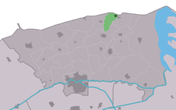
Dongeradeel ) is a former municipality in the northern Netherlands. In 2019 it merged with the municipalities of Ferwerderadiel and Kollumerland en Nieuwkruisland to form the new municipality Noardeast-Fryslân.

<span class="mw-page-title-main">Zoutkamp</span> Village in Groningen, Netherlands

Zoutkamp is a village in the municipality Het Hogeland which is part of the province Groningen in the Netherlands. The village started as a sconce. During the Dutch Revolt, it was the site of the Battle of Zoutkamp. Later it became a fishing village. The harbour was moved to Lauwersoog in 1969 as a result of the closure of the Lauwersmeer, and is nowadays used for recreational purposes. The economy of the village mainly depends on fishing.

<span class="mw-page-title-main">Büsum</span> Municipality in Schleswig-Holstein, Germany

Büsum is a fishing and tourist town in the district of Dithmarschen, in Schleswig-Holstein, Germany. It is situated on the North Sea coast, approx. 18 km southwest of Heide.

<span class="mw-page-title-main">Aalsum, Friesland</span> Village in Friesland, Netherlands

Aalsum is a village in the Dutch province of Friesland. It is located in the municipality Noardeast-Fryslân, about 1 km north of Dokkum. It had a population of around 125 in January 2017

<span class="mw-page-title-main">Ie, Noardeast-Fryslân</span> Village in Friesland, Netherlands

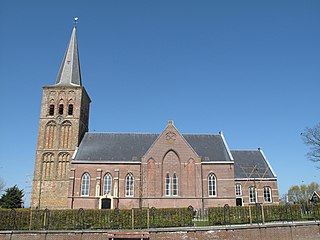
Ie is a village in the northern Netherlands. It is located in the municipality of Noardeast-Fryslân, Friesland, east of Dokkum. Ie had approximately 834 inhabitants in January 2017. Before 2019, the village was part of the Dongeradeel municipality.

<span class="mw-page-title-main">Pieterburen</span> Village in Groningen, Netherlands

Pieterburen is a village in the northeastern Netherlands, located in the municipality of Het Hogeland, Groningen.

<span class="mw-page-title-main">Holwert</span> Village in Friesland, Netherlands

Holwert is a village in Noardeast-Fryslân municipality in the northern Netherlands, in the province of Friesland. It had a population of around 1,607 in January 2017. Before 2019, the village was part of the Dongeradeel municipality.

<span class="mw-page-title-main">Brantgum</span> Village in Friesland, Netherlands

Brantgum is a village in Noardeast-Fryslân in the province of Friesland, the Netherlands. It had a population of around 236 in January 2017. Before 2019, the village was part of the Dongeradeel municipality.

<span class="mw-page-title-main">Ingwierrum</span> Village in Friesland, Netherlands

Ingwierrum is a village in Noardeast-Fryslân in the province of Friesland, the Netherlands. It had a population of approximately 565 in January 2017. Before 2019, the village was part of the Dongeradeel municipality.

<span class="mw-page-title-main">Hiaure</span> Village in Friesland, Netherlands

Hiaure is a small village in Noardeast-Fryslân in the province of Friesland, the Netherlands. It had a population of around 65 in January 2017. Before 2019, the village was part of the Dongeradeel municipality.

<span class="mw-page-title-main">Peazens</span> Village in Friesland, Netherlands

Peazens is a village in Noardeast-Fryslân in the province of Friesland, the Netherlands. It has a population of around 242 in January 2017. Before 2019, the village was part of the Dongeradeel municipality.

<span class="mw-page-title-main">Peazens-Moddergat</span> Village in Friesland, Netherlands

Peazens and Moddergat are two adjacent villages in Noardeast-Fryslân in the province of Friesland, the Netherlands. They have a combined population of around 405 as of 2021. Officially both villages are separate, but they are twinned together with only a canal between them.

<span class="mw-page-title-main">Wierum</span> Village in Friesland, Netherlands

Wierum is a village in Noardeast-Fryslân in the province of Friesland, the Netherlands with a population of around 339 in January 2017. Before 2019, the village was part of the Dongeradeel municipality.

<span class="mw-page-title-main">Tzummarum</span> Village in Friesland, Netherlands

Tzummarum is a village in Waadhoeke municipality in the province of Friesland, the Netherlands. It had a population of around 1,414 in January 2014.

<span class="mw-page-title-main">Wjelsryp</span> Village in Friesland, Netherlands

Wjelsryp is a village in Waadhoeke municipality in the province of Friesland, the Netherlands. It had a population of around 463 in January 2017.

<span class="mw-page-title-main">Lauwersoog</span> Village and harbour in Groningen, Netherlands

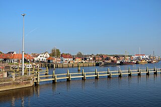
Lauwersoog is a seaside village and harbour in the province of Groningen, located in the northern part of the Netherlands. It is part of the municipality of Het Hogeland. It was established on 23 May 1969. The ferry to Schiermonnikoog departs from Lauwersoog.

<span class="mw-page-title-main">Noardeast-Fryslân</span> Municipality in Friesland, Netherlands

Noardeast-Fryslân is a municipality of Friesland in the northern Netherlands. It was established 1 January 2019 and consists of the former municipalities of Dongeradeel, Ferwerderadiel and Kollumerland en Nieuwkruisland, all three of which dissolved on the same day.

<span class="mw-page-title-main">Westernieland</span> Village in Groningen, Netherlands

Westernieland is a village in the Dutch province of Groningen. It is part of the municipality of Het Hogeland. The village is located near the Wadden Sea.

<span class="mw-page-title-main">Den Andel</span> Village in Groningen, Netherlands

Den Andel is a village in the municipality Het Hogeland which is part of the province Groningen in the Netherlands. It is located about 20 kilometres (12 mi) north of the city of Groningen near the Wadden Sea coast.

References

  1. 1 2 3 "Kerncijfers wijken en buurten 2021". Central Bureau of Statistics. Retrieved 31 March 2022. two entries
  2. "Postcodetool for 9142DL". Actueel Hoogtebestand Nederland (in Dutch). Het Waterschapshuis. Retrieved 31 March 2022.
  3. Aantal inwoners per woonplaats in Dongeradeel op 1 januari 2017 Archived 2017-10-21 at the Wayback Machine - Dongeradeel
  4. 1 2 3 4 "Paesens-Moddergat". Plaatsengids (in Dutch). Retrieved 31 March 2022.
  5. "Translate Moddergat nl->en". Google. Retrieved 31 March 2022.
  6. 1 2 Ronald Stenvert & Sabine Broekhoven (2000). "Paesens-Moddergat" (in Dutch). Zwolle: Waanders. ISBN   90 400 9476 4 . Retrieved 31 March 2022.
  7. "Monument omgekomen zeelieden 1883, De Oere, Moddergat". Online Begraafplaatsen (in Dutch). Retrieved 31 March 2022.
  8. "Moddergat - (geografische naam)". Etymologiebank (in Dutch). Retrieved 31 March 2022.
  9. "t Fiskershúske". Museum.nl (in Dutch). Retrieved 31 March 2022.
  10. "Wadlopen bij Paesens-Moddergat". Wadlopen Moddergat (in Dutch). Retrieved 31 March 2022.
  11. "Verordening van 13 december 1995, houdende regels met betrekking tot het wadlopen (Wadloopverordening 1996)" [1996 law for mudflat hiking](PDF). Waddenzee (in Dutch). 13 December 1995. Retrieved 31 March 2022.

Commons-logo.svg Media related to Moddergat at Wikimedia Commons