Snowdonia, or Eryri, is a mountainous region and national park in North Wales. It contains all 15 mountains in Wales over 3000 feet high, including the country's highest, Snowdon, which is 1,085 metres (3,560 ft) tall. These peaks are all part of the Snowdon, Glyderau, and Carneddau ranges in the north of the region. The shorter Moelwynion and Moel Hebog ranges lie immediately to the south.

The Ffestiniog Railway is a heritage railway based on 1 ft 11+1⁄2 in narrow-gauge, located in Gwynedd, Wales. It is a major tourist attraction located mainly within the Snowdonia National Park.

Blaenau Ffestiniog is a town in Gwynedd, Wales. Once a slate mining centre in historic Merionethshire, it now relies much on tourists, drawn for instance to the Ffestiniog Railway and Llechwedd Slate Caverns. It reached a population of 12,000 at the peak development of the slate industry, but fell with the decline in demand for slate. The population of the community, including the nearby village Llan Ffestiniog, was 4,875 at the 2011 census: the fourth most populous in Gwynedd after Bangor, Caernarfon and Llandeiniolen. The population not including Llan is now only about 4,000.

The Rhinogydd are a range of mountains located east of Harlech in North Wales. The name Rhinogydd derives from the names of two of the more famous peaks, Rhinog Fawr and Rhinog Fach, although the greatest elevation in the range is reached by Y Llethr, 756 m.
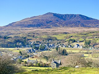
Dolwyddelan is a village and community in Conwy County Borough, Wales. The community occupies most of the valley of the Afon Lledr, and contains the settlements of Dolwyddelan, Pentre Bont, Blaenau Dolwyddelan, and Pont-y-Pant. It lies within Snowdonia, and the surrounding hills are part of the Moelwynion range. The population of the community was recorded as 454 in the 2021 census, and in the 2011 census the proportion of Welsh speakers was recorded as 50.8%.
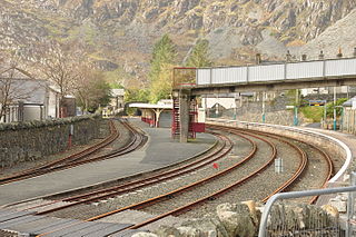
The Conwy Valley line is a railway line in north-west Wales. It runs from Llandudno via Llandudno Junction to Blaenau Ffestiniog, and was originally part of the London and North Western Railway, being opened in stages to 1879. The primary purpose of the line was to carry slate from the Ffestiniog quarries to a specially built quay at Deganwy for export by sea. The line also provided goods facilities for the market town of Llanrwst, and via the extensive facilities at Betws-y-Coed on the London to Holyhead A5 turnpike road it served many isolated communities in Snowdonia and also the developing tourist industry. Although only a little over 27 miles (43 km) between Llandudno and Blaenau Ffestiniog, the journey takes over one hour, largely due to the sinuous and steeply graded nature of the route taken. Most of the stations along the line are treated as request stops.
Moel-yr-hydd is a subsidiary summit of Moelwyn Mawr in Snowdonia, North Wales and forms part of the Moelwynion.

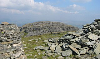
The Moelwynion are a group of mountains in central Snowdonia, north Wales. They extend from the north-east of Porthmadog to Moel Siabod, the highest of the group. The name derives from the names of two of the largest mountains in the group, Moelwyn Mawr and Moelwyn Bach, 770m and 710m, respectively. Moel Siabod, to the north, is the highest at 872m.

Moel Ysgyfarnogod is a mountain in Snowdonia, North Wales and is the northernmost of the Rhinogydd. Rhinog Fawr lies directly south.

Sarn Helen refers to several stretches of Roman road in Wales. The 160-mile (260 km) route, which follows a meandering course through central Wales, connects Aberconwy in the north with Carmarthen in the west. Despite its length, academic debate continues as to the precise course of the Roman road. Many sections are now used by the modern road network while other parts are still traceable. However, there are sizeable stretches that have been lost and are unidentifiable.
The Bala and Festiniog Railway was a 4 ft 8+1⁄2 in, standard gauge, railway backed by the Great Western Railway (GWR) in north-west Wales. It connected Bala with Blaenau Ffestiniog.

Y Fron, also known locally as Cesarea, after the chapel, is a country village on the south-west side of Moel Tryfan, overlooking the Nantlle Valley, in North Wales, near Rhosgadfan and Carmel, on the tail of Mynydd Mawr, with epic views of Trum Y Ddysgl and Craig Cwm Silyn. It is in the community of Llandwrog.
Foel Penolau is a mountain close to Moel Ysgyfarnogod in Snowdonia, North Wales and is the northernmost summit of the Rhinogydd, and overlooks Llyn Trawsfynydd. From the summit it is possible to see the towns of Porthmadog and Blaenau Ffestiniog. As a result of a revised survey of its topographical prominence, Foel Penolau gained Hewitt and Simms status in December 2018 when its prominence was measured to be above 30 m (98 ft).

The Blaen y Cwm quarry was a slate quarry located east of Blaenau Ffestiniog in Wales. It was first worked in some time between 1813 and 1818 and sporadically after that until 1914. The quarry was connected to the Ffestiniog Railway at Duffws Station via the Rhiwbach Tramway.

Y Ro Wen is a mountain just north of Blaenau Ffestiniog, North Wales and forms part of the Moelwynion.

Y Gamallt is a mountain located in the Migneint in Snowdonia, North Wales. It forms part of the Arenig mountain range being separated from the Moelwynion range at the head of Cwm Teigl.

Rhiwbach quarry was a slate quarry located to the east of Blaenau Ffestiniog in North Wales. The quarry was a remote site; it was nearly 4 miles (6.4 km) to north-east of Duffws, the Festiniog Railway's terminus in Blaenau Ffestiniog. It was the connected to the Ffestiniog Railway by the Rhiwbach Tramway. Commercial operation began around 1812, and it finally closed in 1952. It was the last Welsh slate quarry where workers lived in barracks on the site. 'Rhiwbach' is Welsh for 'Little Hill'.

Wrysgan quarry was a slate quarry near the village of Tanygrisiau, Blaenau Festiniog, North Wales. It was worked intermittently from the 1830s, and was worked continuously from c.1850 until 1946. Wrysgan was an underground slate quarry, which was located on a small inaccessible site, some 1,390 feet (420 m) above sea level, to the west of Cwmorthin.
Cwm Prysor Halt was a railway station which served the remote rural area of Cwm Prysor, east of Trawsfynydd, Gwynedd, Wales.

The Penmachno quarry was a slate quarry near Cwm Penmachno, Conwy, North Wales. It was directly below the Rhiwbach Quarry. It was worked between 1818 and 1962.