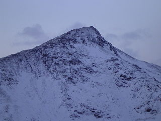
Yr Aran is a mountain peak on a ridge radiating south from Snowdon, Wales' highest mountain, with beautiful views of the summit of Snowdon, Moel Hebog and the Nantlle Ridge.

Moel Hebog is a mountain in Snowdonia, north Wales which dominates the view west from the village of Beddgelert. It gives name to a whole range of peaks in the north-western corner of Snowdonia, which include the Nantlle Ridge and Mynydd Mawr.

Pike of Blisco, or Pike o' Blisco, is a mountain in the Lake District in Cumbria, England. Located between the valleys of Great Langdale and Little Langdale, its relative isolation from neighbouring fells together with slopes falling away immediately from the summit in all directions mean it has excellent views: the view of the Langdale Pikes across Great Langdale is particularly arresting.

Arenig Fawr is a mountain in Snowdonia, North Wales, close to Llyn Celyn reservoir, alongside the A4212 between Trawsfynydd and Bala.

Mynydd Mawr is a mountain in Snowdonia, North Wales, approximately 7 km (4.3 mi) west of Snowdon itself, overlooking Llyn Cwellyn and being the northern outlier of the Moel Hebog group. A popular ascent starts from Rhyd Ddu. On its western flank are the remains of ancient settlements and field systems. The profile of Mynydd Mawr from the north is often thought to resemble an elephant lying down, and consequently the mountain is often colloquially also called "Yr Eliffant", or "Elephant Mountain" by non-Welsh speakers.

Rhyd-ddu is a small village in Snowdonia, North Wales which is a starting point for walks up Snowdon, Moel Hebog, Yr Aran and the Nantlle Ridge.

The geology of the Australian Capital Territory includes rocks dating from the Ordovician around 480 million years ago, whilst most rocks are from the Silurian. During the Ordovician period the region—along with most of eastern Australia—was part of the ocean floor. The area contains the Pittman Formation consisting largely of Quartz-rich sandstone, siltstone and shale; the Adaminaby Beds and the Acton Shale.

The Ilgachuz Range is a name given to an extinct shield volcano in British Columbia, Canada. It is not a mountain range in the normal sense, because it was formed as a single volcano that has been eroded for the past 5 million years. It lies on the Chilcotin Plateau, located some 350 kilometres (220 mi) north-northwest of Vancouver and 30 km north of Anahim Lake. The highest peak of the range is Far Mountain. The range supports a unique grassland ecosystem. This type of grassland has not been seen anywhere else in central and southern British Columbia. The climate is cool and dry; typical of higher elevations of the Interior Plateau.
The Mount Pleasant Caldera is a large eroded Late Devonian volcanic caldera complex, located in the northern Appalachian Mountains of southwestern New Brunswick, Canada. It is one of few noticeable pre-Cenozoic calderas, and its formation is associated to a period of crustal thinning that followed the Acadian orogeny in the northern Appalachian Mountains. It sits relatively near to the coastline.
Craiglwyn is a top of Creigiau Gleision in Snowdonia, Wales, near Capel Curig. It lies at the south end of the Creigiau Gleision ridge, and offers good views of Carnedd Dafydd, Pen yr Helgi Du, Pen Llithrig y Wrach, Gallt yr Ogof, Tryfan and Moel Siabod.

Trum y Ddysgl is a mountain in Snowdonia, north Wales and is the second highest summit on the celebrated Nantlle Ridge. It is also one half of the two Marilyns that make up the ridge, the other being Craig Cwm Silyn.

Moel Lefn is a summit in Snowdonia. It is a subsidiary peak of Moel Hebog and a sister peak of Moel yr Ogof. Its summit marks the end of the Hebog ridge.
Y Foel Goch is a mountain in Snowdonia, north-west Wales, and is a sister peak along with Gallt yr Ogof to Glyder Fach. Between Glyder Fach and its summit lies Llyn Caseg-fraith, a popular lake for photographing Tryfan and its reflection.
Gallt yr Ogof is a mountain in Snowdonia, North Wales. It is a subsidiary top of Glyder Fawr, and is the most easterly point in the Glyderau mountain range, not including the hill Cefn y Capel. Gallt yr Ogof is 763 metres high.

Mynydd Graig Goch is the western end peak of the Nantlle Ridge, and is a subsidiary summit of Craig Cwm Silyn. It is also the most westerly 2000 ft peak in Wales. For many years it was excluded from lists of the Welsh 2000 ft hills due to a spot height of 609m on OS maps. However, this changed in 2008; after years of speculation a group of hillwalkers carried out a precise GPS survey of the peak, measuring the absolute height as 609.75 m (2000.49 ft).

Garreg Las is a subsidiary summit of Fan Brycheiniog in the Brecon Beacons National Park in Carmarthenshire, southern Wales. Its summit sits towards the northern end of a broad north-south ridge, Esgair Hir, at 635 metres (2,083 ft) above sea level. The hill is sometimes referred to as Twyn Swnd.

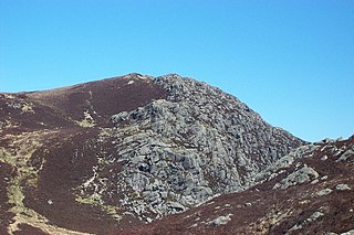
Moel y Gest is a 263 m (863 ft) hill to the west of Porthmadog in North Wales. It is a very rocky hill with high topographic prominence because of the lower land that surrounds it on all sides, and qualifies as a Marilyn. The views from the top are far ranging and include the Llŷn Peninsula, the Rhinogydd, Moelwynion, Moel Hebog, and Snowdon.
This article describes the geology of the Brecon Beacons National Park in mid/south Wales. The area gained national park status in 1957 with the designated area of 1,344 km2 (519 sq mi) including mountain massifs to both the east and west of the Brecon Beacons proper. The geology of the national park consists of a thick succession of sedimentary rocks laid down from the late Ordovician through the Silurian and Devonian to the late Carboniferous period. The rock sequence most closely associated with the park is the Old Red Sandstone from which most of its mountains are formed. The older parts of the succession, in the northwest, were folded and faulted during the Caledonian orogeny. Further faulting and folding, particularly in the south of the park is associated with the Variscan orogeny.
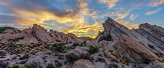
The Vasquez Formation (Tvz) is a geologic formation cropping out at the eponymous Vasquez Rocks in southern California. The formation dates to the Late Oligocene to Early Miocene.

