
Thuringia, officially the Free State of Thuringia, is a state of central Germany, covering 16,171 square kilometres (6,244 sq mi), the sixth smallest of the sixteen German states. It has a population of about 2.1 million.
The Vogtlandkreis is a Landkreis in the southwest of Saxony, Germany, at the borders of Thuringia, Bavaria, and the Czech Republic. Neighbouring districts are Hof, Saale-Orla, Greiz, Zwickau and Erzgebirgskreis. It is the southernmost district in the state.

The Federal Republic of Germany, as a federal state, consists of sixteen states. Berlin, Hamburg and Bremen are called Stadtstaaten ("city-states"), while the other thirteen states are called Flächenländer and include Bavaria, Saxony, and Thuringia, which describe themselves as Freistaaten.

Gera is a city in the German state of Thuringia. With around 93,000 inhabitants, it is the third-largest city in Thuringia after Erfurt and Jena as well as the easternmost city of the Thüringer Städtekette, an almost straight string of cities consisting of the six largest Thuringian cities from Eisenach in the west, via Gotha, Erfurt, Weimar and Jena to Gera in the east. Gera is the largest city in the Vogtland, and one of its historical capitals along with Plauen, Greiz and Weida. The city lies in the East Thuringian Hill Country, in the wide valley of the White Elster, between Greiz (upstream) and Leipzig (downstream). Gera is located in the Central German Metropolitan Region, approximately 60 kilometres south of Saxony's largest city of Leipzig, 80 km east of Thuringia's capital Erfurt, 120 km west of Saxony's capital Dresden and 90 km north of Bavaria's city of Hof (Saale).
Gotha is a Kreis (district) in western central Thuringia, Germany. Neighboring districts are Unstrut-Hainich-Kreis, Sömmerda, the Kreis-free city Erfurt, Ilm-Kreis, Schmalkalden-Meiningen and the Wartburgkreis.
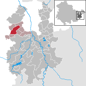
Greiz is a Kreis (district) in the east of Thuringia, Germany. Neighboring districts are Saale-Holzland, Saale-Orla, district-free city Gera, the Burgenlandkreis in Saxony-Anhalt, Altenburger Land, and the two Saxon districts Zwickau and Vogtlandkreis.

Nordhausen is a city in Thuringia, Germany. It is the capital of the Nordhausen district and the urban centre of northern Thuringia and the southern Harz region; its population is 42,000. Nordhausen is located approximately 60 km north of Erfurt, 80 km west of Halle, 85 km south of Braunschweig and 60 km east of Göttingen.

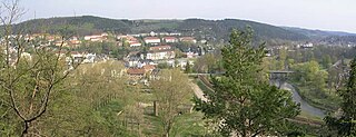
Greiz is a town in the state of Thuringia, Germany, and is the capital of the district of Greiz. Greiz is situated in eastern Thuringia, 100 kilometres (62 mi) east of the state capital Erfurt, on the White Elster river.

Bad Köstritz is a town in the district of Greiz, in Thuringia, Germany. It is situated on the White Elster river, 7 km northwest of Gera. Bad Köstritz is known for the Köstritzer brewery and its Schwarzbier.
Berga/Elster is a former town in the district of Greiz, in Thuringia, Germany. On 1 January 2024 it became part of the town Berga-Wünschendorf. It is situated on the White Elster river, 14 km southeast of Gera.
Münchenbernsdorf is a town in the district of Greiz, in Thuringia, Germany. It is situated approximately 16 km southwest of Gera. The town is seat of a municipal association with eight members.

Weinbergen is a former municipality in the Unstrut-Hainich-Kreis district of Thuringia, Germany. It was created on 30 June 1994 in the course of a territorial reform by the merger of the municipalities of Bollstedt, Grabe, Höngeda and Seebach. On 1 January 2019, Weinbergen was dissolved, and the four villages which it consisted of were incorporated into the territory of the town of Mühlhausen. The Seebach State Bird Protection Station, located in the former municipality, is known beyond the region.

Wünschendorf/Elster is a village and a former municipality in the district of Greiz, in Thuringia, Germany. On 1 January 2024 it became part of the town Berga-Wünschendorf.

Mohlsdorf is a village and a former municipality in the district of Greiz, in Thuringia, Germany. Since 1 January 2012, it is part of the municipality Mohlsdorf-Teichwolframsdorf.
Teichwolframsdorf is a village and a former municipality in the district of Greiz, in Thuringia, Germany. Since January 1, 2012, it is part of the municipality Mohlsdorf-Teichwolframsdorf.

Auma-Weidatal is a town in the district of Greiz, in Thuringia, Germany. It was named after the town Auma and the river Weida, that flows through the municipality. It was formed on 1 December 2011 by the merger of the former municipalities Auma, Braunsdorf, Göhren-Döhlen, Staitz and Wiebelsdorf. Since January 1996, these and three other municipalities had cooperated in the Verwaltungsgemeinschaft Auma-Weidatal. This Verwaltungsgemeinschaft was disbanded on 1 December 2011. The seat of the municipality and of the former Verwaltungsgemeinschaft is in Auma.
The Werdauer-Greizer forest, also known as the Greiz-Werdauer forest or the Werdauer forest, is the conservation forests around Greiz and Werdau and is one of the largest closed forest areas in Western Saxony and eastern Thuringia.
Haide is a hamlet in the municipality of Mohlsdorf-Teichwolframsdorf in the Greiz district of Thuringia, southwest of the hamlet Gottesgrün, located on the Neumark–Greiz railway. The residential area consists of two farmsteads and three other residential buildings.
Greiz II is an electoral constituency represented in the Landtag of Thuringia. It elects one member via first-past-the-post voting. Under the current constituency numbering system, it is designated as constituency 40. It covers the eastern part of the district of Greiz.
Berga-Wünschendorf is a municipality in the district of Greiz, in Thuringia, Germany. The municipality consists of 24 Ortsteile.


