Altenburger Land is a district in Thuringia, Germany. It is bounded by the district of Greiz, the Burgenlandkreis (Saxony-Anhalt), and the districts Leipzig, Mittelsachsen and Zwickau in Saxony. The district is a member of the Central German Metropolitan Region.
Greiz is a Kreis (district) in the east of Thuringia, Germany. Neighboring districts are Saale-Holzland, Saale-Orla, district-free city Gera, the Burgenlandkreis in Saxony-Anhalt, Altenburger Land, and the two Saxon districts Zwickau and Vogtlandkreis.
Sömmerda is a Kreis (district) in the north of Thuringia, Germany. Neighboring districts are the districts Kyffhäuserkreis, the Burgenlandkreis in Saxony-Anhalt, the district Weimarer Land and the district-free city Erfurt, and the districts Gotha and Unstrut-Hainich-Kreis.

Zeulenroda-Triebes is a German town in the district of Greiz in the state of Thuringia.

Jonaswalde is a municipality in the Thuringian district of Altenburger Land. It belongs to the Verwaltungsgemeinschaft of Oberes Sprottental.

Rückersdorf is a municipality in the eastern part of the Thuringian landkreis of Greiz and belongs to the Verwaltungsgemeinschaft of Ländereck.
Linda bei Weida is a German municipality in the Thuringian district of Greiz. It belongs to the Verwaltungsgemeinschaft of Ländereck. Linda is part of the Roman Catholic Diocese of Dresden-Meissen.

Endschütz is a German municipality in the Thuringian district of Greiz. It belongs to the Verwaltungsgemeinschaft of Ländereck.
Heukewalde is a German municipality in the Thuringian Landkreis of Altenburger Land. It belongs to the Verwaltungsgemeinschaft of Oberes Sprottental.
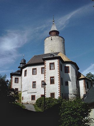
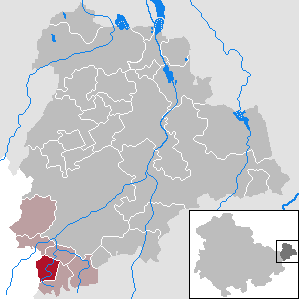
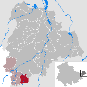
Posterstein is a German municipality in the Thuringian Landkreis of Altenburger Land.

Paitzdorf is a German municipality in the Thuringian Landkreis of Greiz. It belongs to the Verwaltungsgemeinschaft of Ländereck.
Thonhausen is a municipality in the district of Altenburger Land in Thuringia, Germany. It belongs to the Verwaltungsgemeinschaft of Oberes Sprottental.

Hilbersdorf is a German municipality in the Thuringian district of Greiz. It belongs to the Verwaltungsgemeinschaft of Ländereck and lies in upper Wipsetal.

Bad Köstritz is a town in the district of Greiz, in Thuringia, Germany. It is situated on the White Elster river, 7 km northwest of Gera. Bad Köstritz is known for the Köstritzer brewery and its Schwarzbier.

Ronneburg is a town in the district of Greiz, in Thuringia, Germany. It is situated 7 km east of Gera.
Weida is a town in the district of Greiz, in Thuringia, Germany, situated 12 km south of Gera on the river Weida.

Ellweiler is an Ortsgemeinde – a municipality belonging to a Verbandsgemeinde, a kind of collective municipality – in the Birkenfeld district in Rhineland-Palatinate, Germany. It belongs to the Verbandsgemeinde of Birkenfeld, whose seat is in the like-named town.
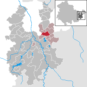
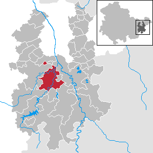
Ländereck is a Verwaltungsgemeinschaft in the district of Greiz, in Thuringia, Germany. The seat of the Verwaltungsgemeinschaft is in Seelingstädt.

SAG/SDAG Wismut was a uranium mining company in East Germany during the time of the Cold War. It produced a total of 230,400 tonnes of uranium between 1947 and 1990 and made East Germany the fourth largest producer of uranium ore in the world at the time. It was the largest single producer of uranium ore in the entire sphere of control of the USSR. In 1991 after German reunification it was transformed into the Wismut GmbH company, owned by the Federal Republic of Germany, which is now responsible for the restoration and environmental cleanup of the former mining and milling areas. The head office of SDAG Wismut / Wismut GmbH is in Chemnitz-Siegmar.
Greiz II is an electoral constituency represented in the Landtag of Thuringia. It elects one member via first-past-the-post voting. Under the current constituency numbering system, it is designated as constituency 40. It covers the eastern part of the district of Greiz.


