
Bushmeat is meat from wildlife species that are hunted for human consumption. Bushmeat represents a primary source of animal protein and a cash-earning commodity for inhabitants of humid tropical forest regions in Africa, Latin America and Asia. Bushmeat is an important food resource in poor, rural communities.

The East Region occupies the southeastern portion of the Republic of Cameroon. It is bordered to the east by the Central African Republic, to the south by Congo, to the north by the Adamawa Region, and to the west by the Centre and South Regions. With 109,002 km2 of territory, it is the largest region in the nation as well as the most sparsely populated. Historically, the peoples of the East have been settled in Cameroonian territory for longer than any other of the country's many ethnic groups, the first inhabitants being the Baka pygmies.
The oral polio vaccine (OPV) AIDS hypothesis is a now-discredited hypothesis that the AIDS pandemic originated from live polio vaccines prepared in chimpanzee tissue cultures, accidentally contaminated with simian immunodeficiency virus and then administered to up to one million Africans between 1957 and 1960 in experimental mass vaccination campaigns.

The South Region is located in the southwestern and south-central portion of the Republic of Cameroon. It is bordered to the east by the East Region, to the north by the Centre Region, to the northwest by the Littoral Region, to the west by the Gulf of Guinea, and to the south by the countries of Equatorial Guinea, Gabon, and Congo. The South occupies 47,720 km2 of territory, making it the fourth largest region in the nation. The major ethnic groups are the various Beti-Pahuin peoples, such as the Ewondo, Fang, and Bulu.
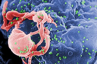
AIDS is caused by a human immunodeficiency virus (HIV), which originated in non-human primates in Central and West Africa. While various sub-groups of the virus acquired human infectivity at different times, the present pandemic had its origins in the emergence of one specific strain – HIV-1 subgroup M – in Léopoldville in the Belgian Congo in the 1920s.
HIV/AIDS was recognised as a novel illness in the early 1980s. An AIDS case is classified as "early" if the death occurred before 5 June 1981, when the AIDS epidemic was formally recognized by medical professionals in the United States.

The Dja River is a stream in west-central Africa. It forms part of Cameroon–Republic of Congo border and has a course of roughly 720 kilometres (450 mi).
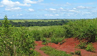
The South Cameroon Plateau or Southern Cameroon Plateau is the dominant geographical feature of Cameroon. The plateau lies south of the Adamawa Plateau and southeast of the Cameroon Range. It slopes south and west until giving way to the Cameroon coastal plain in the southwest and the Congo River basin in the southeast. The plateau is characterised by hills and valleys in the southwest and a more gentle peneplain in the southwest. Isolated massifs occur, especially in the southwest. Metamorphic rocks make up the plain's basement. The soils are ferrallitic and lateritic, with colouration ranging from red or brown in the interior to yellow on the coast. The soils are subjected to silica leeching, so they are not productive without fertiliser.

The wildlife of Cameroon is composed of its flora and fauna. Bordering Nigeria, it is considered one of the wettest parts of Africa and records Africa's second highest concentration of biodiversity. To preserve its wildlife, Cameroon has more than 20 protected reserves comprising national parks, zoos, forest reserves and sanctuaries. The protected areas were first created in the northern region under the colonial administration in 1932; the first two reserves established were Mozogo Gokoro Reserve and the Bénoué Reserve, which was followed by the Waza Reserve on 24 March 1934. The coverage of reserves was initially about 4 percent of the country's area, rising to 12 percent; the administration proposes to cover 30 percent of the land area.
Xenopus boumbaensis, the Mawa clawed frog, is a species of frog in the family Pipidae. It is known from a few localities in central and south-eastern Cameroon, and from north-western Republic of Congo and extreme south-western Central African Republic; it probably occurs more widely in the central African forest belt, but identification is difficult: it is one of the cryptic species that resemble Xenopus fraseri, from which it can be distinguished by chromosome number (2n=72) and a male advertisement call of a single note.
Boumba Bek National Park is a national park in extreme southeastern Cameroon, located in its East Province.
Nki National Park is a national park in southeastern Cameroon, located in its East Province. The closest towns to Nki are Yokadouma, Moloundou and Lomie, beyond which are rural lands. Due to its remoteness, Nki has been described as "the last true wilderness." It has a large and varied ecosystem, and it is home to over 265 species of birds, and the forests of Cameroon contain some of the highest population density of forest elephants of any nation with an elephant density of roughly 2.5 per square kilometer for Nki and neighboring Boumba Bek National Park combined. These animals are victims of poaching, which has been a major problem since an economic depression in the 1980s. The indigenous people follow in the footsteps of the poachers, attracted by the financial opportunities. The removal of logging industries from the park, on the other hand, has been a success; it is no longer considered a major threat to Nki's wilderness.
Baka is a dialect cluster of Ubangian languages spoken by the Baka Pygmies of Cameroon and Gabon. The people are ethnically close to the Aka, the two together called the Mbenga (Bambenga), but the languages are not related, apart from some vocabulary dealing with the forest economy, which suggests the Aka may have shifted to Bantu, probably 15000 people have shifted.

Lobéké National Park is a national park of southeastern Cameroon within the Moloundou Arrondissement of East Province. Located in the Congo Basin, it is bounded on the east by the Sangha River which serves as Cameroon's international border with Central African Republic and the Republic of the Congo. It is adjacent to two other reserves in the CAR and Congo. To the northwest is Boumba Bek National Park, another national park in Cameroon's East Province.
Bangando and Ngombe constitute a Gbaya language of Cameroon and CAR.
Mpumpong (Mpongmpong) is a Bantu language of Cameroon. Maho (2009) considers Mpiemo to be a dialect.

Boumba River is a river in the South Cameroon Plateau of southeast Cameroon.

The Northwestern Congolian lowland forests is a tropical moist broadleaf forest ecoregion that spans Cameroon, Gabon, the Republic of Congo, the Central African Republic and a minuscule part of the Democratic Republic of the Congo. It forms part of the larger Congolian rainforests region in Central Africa. The region is noteworthy for very high levels of species richness and endemism. It is home to a core population of the critically endangered Western lowland gorilla. There are also large populations of forest elephants.

The Ngoyla Faunal Reserve is a 1,566 sq km-large protected area, which is situated in the south-eastern part of Cameroon. It is an important shelter and corridor for the Congolian rainforests megafauna within the tri-national Dja-Odzala-Minkébé protected area complex (TRIDOM).

