
The East Region occupies the southeastern portion of the Republic of Cameroon. It is bordered to the east by the Central African Republic, to the south by Congo, to the north by the Adamawa Region, and to the west by the Centre and South Regions. With 109,002 km2 of territory, it is the largest region in the nation as well as the most sparsely populated. Historically, the peoples of the East have been settled in Cameroonian territory for longer than any other of the country's many ethnic groups, the first inhabitants being the Baka pygmies.

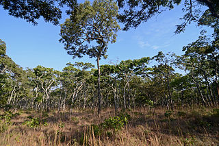
The Northern Congolian forest–savanna mosaic is a forest and savanna ecoregion of central Africa. It extends east and west across central Africa, covering parts of Cameroon, Central African Republic, Democratic Republic of the Congo, South Sudan, and Uganda. It is part of the belt of transitional forest-savanna mosaic that lie between Africa's moist equatorial Guineo-Congolian forests and the tropical dry forests, savannas, and grasslands to the north and south.

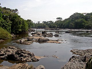
The Dja River is a stream in west-central Africa. It forms part of Cameroon–Republic of Congo border and has a course of roughly 720 kilometres (450 mi).

The wildlife of Cameroon is composed of its flora and fauna. Bordering Nigeria, it is considered one of the wettest parts of Africa and records Africa's second highest concentration of biodiversity. To preserve its wildlife, Cameroon has more than 20 protected reserves comprising national parks, zoos, forest reserves and sanctuaries. The protected areas were first created in the northern region under the colonial administration in 1932; the first two reserves established were Mozogo Gokoro Reserve and the Bénoué Reserve, which was followed by the Waza Reserve on 24 March 1934. The coverage of reserves was initially about 4 percent of the country's area, rising to 12 percent; the administration proposes to cover 30 percent of the land area.
Xenopus boumbaensis, the Mawa clawed frog, is a species of frog in the family Pipidae. It is known from a few localities in central and south-eastern Cameroon, and from north-western Republic of Congo and extreme south-western Central African Republic; it probably occurs more widely in the central African forest belt, but identification is difficult: it is one of the cryptic species that resemble Xenopus fraseri, from which it can be distinguished by chromosome number (2n=72) and a male advertisement call of a single note.

The Atlantic Equatorial coastal forests, also known as the Congolian coastal forests, are a tropical moist broadleaf forest ecoregion of Central Africa, covering hills, plains, and mountains of the Atlantic coast of Cameroon, Equatorial Guinea, Gabon, Republic of the Congo, Angola, and Democratic Republic of the Congo.
Campo Ma'an National Park is a 2,680 square kilometer National Park in Cameroon, located in the South Region in the Océan division. It borders with Equatorial Guinea on the south, the Atlantic Ocean to its west, the Vallée-du-Ntem and the Mvila to the east. Total area of the park and buffer zone measure approximately 700, 000 hectares. The climate has two dry seasons, November to March and July to August, and two rainy seasons, April to June and August to October. Average temperature is 25°C.
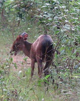
Nki National Park is a national park in southeastern Cameroon, located in its East Province. The closest towns to Nki are Yokadouma, Moloundou and Lomie, beyond which are rural lands. Due to its remoteness, Nki has been described as "the last true wilderness." It has a large and varied ecosystem, and it is home to over 265 species of birds, and the forests of Cameroon contain some of the highest population density of forest elephants of any nation with an elephant density of roughly 2.5 per square kilometer for Nki and neighboring Boumba Bek National Park combined. These animals are victims of poaching, which has been a major problem since an economic depression in the 1980s. The indigenous people follow in the footsteps of the poachers, attracted by the financial opportunities. The removal of logging industries from the park, on the other hand, has been a success; it is no longer considered a major threat to Nki's wilderness.
Moloundou is an arrondissement (district) in the Boumba-et-Ngoko Division of southeastern Cameroon's East Province. Mouloundou is close to Boumba Bek and Nki National Parks on the Dja River. It has a mayor and several decentralised administrative services. Moloundou sits on the Ngoko River, directly across from Congo-Brazzaville.
The Central Zambezian miombo woodlands ecoregion spans southern central Africa. Miombo woodland is the predominant plant community. It is one of the largest ecoregions on the continent, and home to a great variety of wildlife, including many large mammals.

Nouabalé-Ndoki National Park is a national park in the Republic of the Congo. Established in 1993, in the northern provinces of Congo, it is home to forest elephants, great apes, including western lowland gorillas and the eastern sub-species of chimpanzees and bongo. It is 3,921.61 km2 (1,514.14 sq mi) of pristine tropical rainforest with no human habitation within it and with human population densities in its periphery that are comparatively low for the sub-region. The forests have a rich biodiversity of 300 bird species, plus 1,000 plant and tree species which include endangered mahoganies.

Lobéké National Park is a national park of southeastern Cameroon within the Moloundou Arrondissement of East Province. Located in the Congo Basin, it is bounded on the east by the Sangha River which serves as Cameroon's international border with Central African Republic and the Republic of the Congo. It is adjacent to two other reserves in the CAR and Congo. To the northwest is Boumba Bek National Park, another national park in Cameroon's East Province.

The Dzanga-Sangha Special Reserve is a protected reserve of southwestern Central African Republic. It was established in 1990 and covers 6865.54 km2. It is one of several areas within the Dzanga-Sangha Complex of Protected Areas (DSCPA), each within its own protective status and along with Lobéké National Park in Cameroon and Nouabalé-Ndoki National Park in Republic of Congo, it is part of the Sangha Trinational Landscape. Other areas within the DSCPA include the Dzanga Ndoki National Park which has two sectors, the 495 km2 (191 sq mi) Dzanga park and the 725 km2 (280 sq mi) Ndoki park. A conference of the Ministers of Forests of Central African Forest Commission (COMIFAC) had resolved to establish within the Congo basin, the Sangha River Tri-national Protected area (STN) encompassing these three parks. The forest special reserve is operated by the Central African Forest Commission (COMIFAC).

The Dzanga-Sangha Complex of Protected Areas (DSPAC) is a protected area in the extreme southwestern Central African Republic. The dense forest block, created in 1990, measures 4,589 km2 (1,772 sq mi). It consists of the Dzanga-Sangha Special Reserve and the Dzanga Ndoki National Park which has two sectors, the 495 km (308 mi) Dzanga Park and the 725 km (450 mi) Ndoki Park. Since their gazetting, management of the park and the reserve has been under the Dzanga-Sangha project, a collaborative effort of the country's government, the GTZ/LUSO, a German technical agency, and the World Wildlife Fund. Financial and technical assistance have been provided by the German and United States governments, the World Bank, and several private organizations and donors.
Wildlife in the Central African Republic is in the vast natural habitat located between the Congo Basin's rain forests and large savannas, where the human density was smaller than 0.5 per km2 prior to 1850. The forest area of 22.755 million, considered one of the richest storehouses of wildlife spread over national parks, hunting reserves and community hunting areas, experienced an alarming loss of wildlife because of greed for ivory and bushmeat exploitation by hunters – mostly Arab slavers from across the borders of the Central African Republic with Chad and Sudan.

Boumba River is a river in the South Cameroon Plateau of southeast Cameroon.
The Northeastern Congolian lowland forests is a tropical moist broadleaf forest ecoregion that spans the Democratic Republic of the Congo and the Central African Republic.
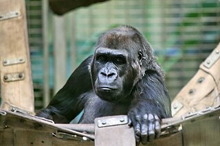
The Northwestern Congolian lowland forests is a tropical moist broadleaf forest ecoregion that spans Cameroon, Gabon, the Republic of Congo, the Central African Republic and a minuscule part of the Democratic Republic of the Congo. It forms part of the larger Congolian rainforests region in Central Africa. The region is noteworthy for very high levels of species richness and endemism. It is home to a core population of the critically endangered Western lowland gorilla. There are also large populations of forest elephants.

The Ngoyla Faunal Reserve is a 1,566 sq km-large protected area, which is situated in the south-eastern part of Cameroon. It is an important shelter and corridor for the Congolian rainforests megafauna within the tri-national Dja-Odzala-Minkébé protected area complex (TRIDOM).
