
Burton upon Trent, also known as Burton-on-Trent or simply Burton, is a market town in the borough of East Staffordshire in the county of Staffordshire, England, close to the border with Derbyshire. In 2021, it had a population of 76,270. The demonym for residents of the town is Burtonian. Burton is located 11 miles (18 km) south-west of Derby, 27 miles (43 km) north-west of Leicester, 28 miles (45 km) west-south-west of Nottingham and 20 miles (32 km) south of the southern entrance to the Peak District National Park.

Icknield Street or Ryknild Street is a Roman road in England, with a route roughly south-west to north-east. It runs from the Fosse Way at Bourton on the Water in Gloucestershire to Templeborough in South Yorkshire. It passes through Alcester, Studley, Redditch, Metchley Fort, Birmingham, Sutton Coldfield, Lichfield, Burton upon Trent and Derby.
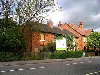
Mickleover is a village in the unitary authority of Derby, in Derbyshire, England. It is 2 miles (3.2 km) west of Derby, 10 miles (16 km) northeast of Burton upon Trent, 13 miles (21 km) southeast of Ashbourne and 12 miles (19 km) northeast of Uttoxeter.

Willington is a Village and civil parish in the South Derbyshire district of Derbyshire, England. The 2001 Census recorded a parish population of 2,604, increasing to 2,862 at the 2011 Census.

Alrewas is a village and civil parish in the Lichfield District of Staffordshire, England.

The River Dove is the principal river of the southwestern Peak District, in the Midlands of England, and is around 45 miles (72 km) in length. It rises on Axe Edge Moor near Buxton and flows generally south to its confluence with the River Trent at Newton Solney. From there, its waters reach the North Sea via the Humber Estuary. For almost its entire course it forms the boundary between the counties of Staffordshire and Derbyshire. The river meanders past Longnor and Hartington and cuts through a set of deep limestone gorges, Beresford Dale, Wolfscote Dale, Milldale and Dovedale.
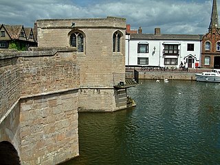
St Ives Bridge is a 15th-century bridge crossing the River Great Ouse in St Ives, Cambridgeshire, England. It is noted for being one of only four bridges in England to incorporate a chapel.
Stretton is a large village and civil parish in Staffordshire, England. It is situated on the northern outskirts of Burton upon Trent and is now a suburb. The name is Old English and means Street Town derived from its location on the Roman road called Ryknild Street. The population of the parish at the 2001 census was 8,355, increasing to 8,611 at the 2011 Census.
Egginton is a village and civil parish in the local government district of South Derbyshire, England. The population of the civil parish as of the 2011 census was 574.

The Limestone Way is a waymarked long-distance footpath in Derbyshire, England. It runs for 46 miles (74 km) through the White Peak of the Peak District National Park, from Castleton south to Rocester over the county boundary into Staffordshire. The trail is named for the limestone scenery along its route. It was devised by Brian Spencer of Matlock Rotary Club and developed and opened in 1986 by the West Derbyshire District Council. It originally ran to Matlock, but was extended to its current, longer route in 1992 to join up with the Staffordshire Way.
The Derbyshire and Staffordshire extension of the Great Northern Railway was an English railway network built by the GNR to get access to coal resources in the area to the north and west of Nottingham. The Midland Railway had obstructed the GNR in its attempts to secure a share of the lucrative business of transporting coal from the area, and in frustration the GNR built the line. The line was forked: it reached Pinxton in 1875 and a junction with the North Staffordshire Railway at Egginton, approaching Burton on Trent in 1878. The line cut through Derby, resulting in considerable demolition of housing there.

Derby Friargate railway station was the main station in Derby on the Great Northern Railway Derbyshire Extension, popularly known as the (Derby) Friargate Line.
Winshill is an area to the east of the town of Burton upon Trent, in the borough of East Staffordshire, England.
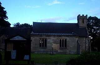
Dalbury Lees is a parish in south Derbyshire. The population of the civil parish as taken at the 2011 Census was 306. It is about six miles (10 km) from both Burton-on-Trent and Derby and just under four miles (6 km) from Egginton. The parish contains the villages of Dalbury and Lees which are just under 2 miles (3.2 km) apart from one another. Dalbury Lees has been known, as Dalbury and as Dalbury with Lees, but Dalbury Lees is the preferred term.
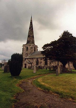
Marston on Dove is a village and civil parish in South Derbyshire, nine miles (14 km) south west of Derby and two miles (3.2 km) east of Tutbury. The Church of St Mary at Marston has the oldest bell in Derbyshire, which was cast in Leicester in 1366 and inscribed with the words "Hail Mary" by John de Stafford.

The Battle of Burton Bridge was fought between Royalist and Parliamentarian forces at Burton upon Trent on 4 July 1643 during the First English Civil War. By the time of the battle, the town, which had at various times been held by both sides, was garrisoned by a Parliamentarian unit under the command of Captain Thomas Sanders and the town's military governor, Colonel Richard Houghton. The key river crossing at Burton was desired by Queen Henrietta Maria, who was proceeding southwards from Yorkshire with a convoy of supplies destined for King Charles I at Oxford. The Royalists, led by Colonel Thomas Tyldesley, launched a cavalry charge across the bridge which succeeded in defeating the Parliamentarians and capturing most of their officers, including Sanders and Houghton. The Queen's convoy proceeded on its way south to Oxford, with Tyldesley receiving a knighthood and a promotion in recognition of his victory. Burton changed hands several more times during the course of the war, before finally coming under Parliamentarian control in 1646.

Handyside Bridge, also known as Derwent Bridge, is a former railway bridge in Darley Abbey, Derbyshire, England which was converted to a foot bridge in 1976 following closure of the railway in 1968.

The Bailey Bridge is a crossing of the River Trent at Walton-on-Trent on the border of Derbyshire and Staffordshire in England. The bridge is only one lane wide with access controlled by a tidal flow system controlled by signals at either end of the bridge. A separate footbridge is attached to the northern side of the structure.

Sinai Park House is a grade II* listed building in Burton upon Trent, Staffordshire, England. Consisting of a central range with two wings the building is sited on a ridge of high ground near a chalybeate spring. The earliest remains of the site date to the 13th-century and it was occupied by the de Scobenhal family before being donated to Burton Abbey. The house was used as a place of convalescence for monks recovering from blood-letting procedures and its original name "seyney house" derived from the Old French "seyne" for blood. The estate was increased by enclosure and used as a hunting ground for the abbot. Much of the estate and house were let out by the early 16th century. The estate came into the hands of the Paget family after the Dissolution of the Monasteries. The Pagets used it for hunting and let out part of the estate to farmers. The house adopted its modern name of Sinai by the end of the 18th-century, a biblical reference.

Dove Bridge is a medieval bridge across the River Dove on the boundary of Staffordshire and Derbyshire in England. A river crossing has existed here since before the 1086 Domesday Book, on the road between Derby and Newcastle-under-Lyme. The current structure, a six-arch bridge, is thought to date from the 15th century, though it has been subject to later repairs and significant widening work in 1913. A larger replacement bridge was constructed in the 1970s and now carries the A50 dual carriageway. Dove Bridge is now only used by pedestrian and farm traffic.


