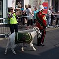
Monmouth is a market town and community in Monmouthshire, Wales, situated on where the River Monnow joins the River Wye, two miles from the Wales–England border. The population in the 2011 census was 10,508, rising from 8,877 in 2001. Monmouth was the county town of historic Monmouthshire, although Abergavenny is the largest settlement and Monmouthshire County Council has its main offices at Rhadyr, just outside Usk. Monmouth is in the UK Parliament constituency of Monmouthshire and the Senedd constituency of Monmouth.

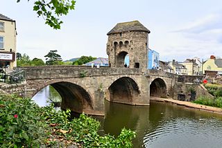
Monnow Bridge, in Monmouth, Wales, is the only remaining fortified river bridge in Great Britain with its gate tower standing on the bridge. Such bridge towers were common across Europe from medieval times, but many were destroyed due to urban expansion, diminishing defensive requirements and the increasing demands of traffic and trade. The historical and architectural importance of the bridge and its rarity are reflected in its status as a scheduled monument and a Grade I listed building. The bridge crosses the River Monnow 500 metres (1,600 ft) above its confluence with the River Wye.
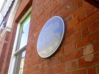
Blestium was a small fort and iron working centre in the Roman province of Britannia Superior, part of Roman Britain. It has been identified with the site of the later town of Monmouth in south east Wales, located adjoining the confluence of the River Monnow with the River Wye. A plaque on the local bank records its position.

The Shire Hall, Monmouth, Wales, is a prominent building on Agincourt Square in the town centre. It was built in 1724, and was formerly the centre for the assize courts and quarter sessions for Monmouthshire. The building was also used as a market place. In 1839–40, the court was the location of the trial of the Chartist leader John Frost and others for high treason for their part in the Newport Rising.

The Church of St Thomas the Martyr at Overmonnow, Monmouth, south east Wales, is located beside the medieval Monnow Bridge across the River Monnow. At least part of the building dates from around 1180, and it has a fine 12th-century Norman chancel arch, though the exterior was largely rebuilt in the early 19th century. It is one of 24 buildings on the Monmouth Heritage Trail and is a Grade II* listed building.

St Mary's Roman Catholic Church, in St Mary's Street near the centre of Monmouth, is the earliest post-Reformation Catholic public place of worship to be permitted in Wales. The church is a late Georgian Roman Catholic church with later Victorian additions by the Catholic convert architect Benjamin Bucknall. It has been designated as a Grade II listed building since 15 August 1974, and is one of 24 buildings on the Monmouth Heritage Trail.

Monmouth Priory, in Priory Street, Monmouth, Wales, is a building that incorporates the remains of the monastic buildings attached to St Mary's Priory Church. The priory was a Benedictine foundation of 1075, and parts of the mediaeval buildings remain. The buildings were substantially redeveloped in the nineteenth century for use as St Mary's National School, and now form a community centre. The complex is a Grade II* listed building as of 27 June 1952. It is one of 24 sites on the Monmouth Heritage Trail.

The Market Hall, in Priory Street, Monmouth, Wales, is an early Victorian building by the prolific Monmouth architect George Vaughan Maddox. It was constructed in the years 1837–39 as the centrepiece of a redevelopment of part of Monmouth town centre. After being severely damaged by fire in 1963, it was partly rebuilt and was the home of Monmouth Museum from 1969 to 2021. At the rear of the building are original slaughterhouses, called The Shambles, opening onto the River Monnow. The building is Grade II listed as at 27 June 1952, and it is one of 24 buildings on the Monmouth Heritage Trail. The Shambles slaughterhouses are separately listed as Grade II*.

George Vaughan Maddox was a nineteenth-century British architect and builder, whose work was undertaken principally in the town of Monmouth, Wales, and in the wider county. Working mainly in a Neo-Classical style, his extensive output made a significant contribution to the Monmouth townscape. The architectural historian John Newman considers that Monmouth owes to Maddox "its particular architectural flavour. For two decades from the mid-1820s he put up a sequence of public buildings and private houses in the town, in a style deft, cultured, and only occasionally unresolved." The Market Hall and 1-6 Priory Street are considered his "most important projects".

Church Street is a pedestrianised street in the centre of Monmouth, Wales. It contains a variety of independent shops, restaurants, commercial art galleries, and the Savoy Theatre. Until the 1830s, when Priory Street was built to bypass it, it was the main thoroughfare into the centre of Monmouth from the north-east, linking the market and the parish church. It was at one time the centre of the town's butchery trade and was known as Butcher's Row.

Overmonnow is a suburb of the town of Monmouth, in Wales, which is located to the west of the River Monnow and the Monnow Bridge. It developed in the Middle Ages, when it was protected by a defensive ditch, the Clawdd-du or "Black Dyke", the remains of which are now protected as an ancient monument. In later centuries the area became known as "Little Monmouth" or "Cappers' Town".

The Cross is situated in St Thomas' Square, Overmonnow, Monmouth, Wales, in the middle of a roundabout opposite the Church of St Thomas the Martyr and the western end of the Monnow Bridge. Originally mediaeval, and also known as Overmonnow Cross, the cross was reconstructed in 1888 and has been classed as a Grade II listed structure since 15 August 1974.

Agincourt Square is an open space in the centre of Monmouth, Wales, in front of the Shire Hall. The area has been used for public functions and markets over the centuries.
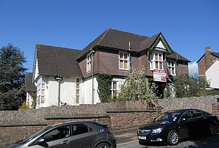
The Cottage Hospital was a community hospital on the Hereford Road in Monmouth, Wales.
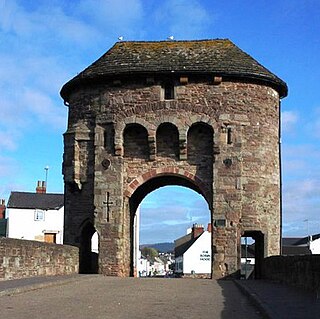
The Monmouth town walls and defences comprise the defensive system of town walls and gates built in Monmouth, Wales between 1297 and the early part of the following century. Wye Bridge Gate, East Gate, Monk's Gate, and Monnow Bridge Gate were access points to the town. West Gate, across Monnow Street, also provided access. Only the Monnow Bridge Gatehouse survives intact, albeit in a substantially modified version from the original.

Wye Bridge Ward was one of four wards in the town of Monmouth, Monmouthshire, Wales. Streets in the ward included St Mary's Street, Almshouse Street, St James Street, St James Square, Whitecross Street and Monk Street. The ward existed as a division of the town by the early seventeenth century, and continued into the twentieth century.

St Cenedlon's is a parish church in the village of Rockfield, Monmouthshire, Wales. The dedication to St Cenedlon is unusual and the history of the saint is obscure. Some sources suggest that she was a daughter of Brychan king of Brycheiniog while others identify her as the wife of King Arthfael ab Ithel, king of Glywysing. The existing church dates from the Middle Ages but only the tower remains from that period. After the English Reformation, the surrounding area of north Monmouthshire became a refuge for Catholics and Matthew Pritchard (1669-1750), Roman Catholic bishop and Vicar Apostolic of the Western District is buried at the church. By the mid-19th century the church was in ruins and a complete reconstruction was undertaken by the ecclesiastical architects John Pollard Seddon and John Prichard in around 1860. St Cenedlon's is an active parish church in the Diocese of Monmouth. It is designated by Cadw as a Grade II listed building.

1–6 Priory Street in Monmouth, Wales, is a row of six shop houses designed by the architect George Vaughan Maddox and constructed c. 1837. They form part of Maddox's redevelopment of the centre of Monmouth and stand opposite his Market Hall. The architectural historian John Newman has written that Maddox's work "gives Monmouth its particular architectural flavour," and considers Priory Street to be "his greatest work."

12–16 Church Street in Monmouth, Wales, is a row of three shop houses designed by the architect George Vaughan Maddox and constructed c. 1837. They form part of Maddox's redevelopment of the centre of Monmouth and stand on Church Street, to the rear of Maddox's Priory Street. The architectural historian John Newman has written that Maddox's work "gives Monmouth its particular architectural flavour" and Cadw describes the grouping of 12–16 Church Street as "the best preserved early 19th century shopfront in Monmouth."

Perth-hir House, Rockfield, Monmouthshire, Wales, was a major residence of the Herbert family. It stood at a bend of the River Monnow, to the north-west of the village. At its height in the 16th century, the mansion, entered by two drawbridges over a moat, comprised a great hall and a number of secondary structures. Subsequently in the ownership of the Powells, and then the Lorimers, the house became a centre of Catholic recusancy following the English Reformation. By the 19th century, the house had declined to the status of a farmhouse and it was largely demolished in around 1830. Its ruins, and the site which contains considerable remnants of a Tudor garden, are a scheduled monument.


