Monk Street, Monmouth

Last updated

Monk Street
Old map of Monmouth, Wales.jpg
Cartographer John Speed's 1610 Map of Monmouth, Monmouthshire, Wales demonstrates Monk Street
Location Monmouth, Wales
Coordinates 51°48′49″N2°42′46″W / 51.813725°N 2.712778°W / 51.813725; -2.712778 Coordinates: 51°48′49″N2°42′46″W / 51.813725°N 2.712778°W / 51.813725; -2.712778
South end Whitecross Street

Monk Street is an historic street in the town of Monmouth, Monmouthshire, Wales. A portion of it was in existence by the 14th century, and appears on the 1610 map of the town by cartographer John Speed. It runs in a north-south direction, extending northward from its intersection with Whitecross Street. The name of the street relates to the nearby Priory, as well as the gate which was originally on this road and provided part of the town's defences, Monk's Gate. Monk Street is lined with numerous listed buildings.

Contents

History and location

By the 14th century, a portion of the street plan of Monmouth had been determined. [1] It is believed that Monk Street derived its name from the nearby Priory. [2] On the map of the town of Monmouth (pictured) created by John Speed in 1610, Monk Street extends from its intersection with Whitecross Street northward to Monk's Gate. Monk's Gate was a component of the town's defences. [3] While the gates of the town outlasted the walls themselves, Monk's Gate was removed in 1710. The curved wall at the Masonic Hall entrance may indicate its previous location. [1] [3] On current maps, Monk Street extends northward from Whitecross Street to the intersection with Priory Street on the west and New Dixton Road on the east. [4] Priory Street was designed by architect George Vaughan Maddox and built in the 1830s as a bypass to reduce carriage traffic in Church Street, which was eventually pedestrianized. [1] [5] [6] Monk Street continues northward beyond the intersection, although in some maps or texts the segment past the intersection is referred to as The Parade or North Parade. [7] In addition, on some modern maps, the eastern leg of Whitecross Street, from the intersection with Monk Street to its termination at the roundabout encircling St James' Square, is also referred to as St James' Square, such that some buildings on Whitecross Street have two addresses. [7] [8]

Buildings

1 Monk Street (pictured below), the former Working Men's Free Institute, is a grade II listed building. It was built by Newport architect Benjamin Lawrence and has a facade of Old Red Sandstone and Bath Stone trim. It is located next to Monmouth Baptist Church, also built by Lawrence. It now houses an art gallery and shop. [1] [9] [10] [11]

The Monmouth Baptist Church (pictured below) at 3 Monk Street is an early-20th-century, grade II listed building. Also referred to as the Baptist Chapel, it was designed by Newport architect Benjamin Lawrence. The chapel was built in the Gothic style in 1906–1907. The two-storey building features a Welsh slate roof, red sandstone walls, and an octagonal bell tower. It is located on the east side of Monk Street, opposite St. Mary's Church. [1] [9] [12] [13]

5 Monk Street is a listed building. [14]

The Royal George Hotel (pictured below), on Monk Street, is an early-18th-century, grade II* listed building. Also referred to as the Ivy Bank House or Ivy Bank Hotel, the building features Corinthian pillars and a hipped slate roof. It was built in the 1730s and converted to apartments in the 1970s. It is located across the road from the Oak House. [1] [15] [16] [17]

Oak House (pictured below) at 6 Monk Street is a 19th-century, grade II listed building. It was built in the 1840s by architect by George Vaughan Maddox. The three-storey house has three bays along the entrance elevation on Monk Street, while the north elevation along Priory Street has four bays. There is a hipped slate roof with two chimneys. It now serves as the Telephone Exchange and is located opposite the Royal George. [1] [18]

7 Monk Street, on the east side of the road, is also referred to as Ty Mawr. It is an early-19th-century, three-story, grade II listed building with a stucco exterior. [19] [20]

Kingsley House and Hendre House (pictured below) at 8 Monk Street and 10 Monk Street are a pair of semi-detached dwellings. The complex is an early-19th-century, grade II listed building. The three-storey, five-bay house has a hipped slate roof. The entrance has a six panelled door with a fanlight. The stucco facade is notable for its blocked central windows. The building is the work of architect George Vaughan Maddox. [1] [21] [22] [23] [24]

9 Monk Street is an early-19th-century, grade II listed building. Also referred to as Sanroyd House, it is a 3-storey building with a stucco exterior and slate roof. [6] [7] [25] [26]

The Masonic Hall (pictured below) was converted from a theatre by George Vaughan Maddox in 1846. The previous Monk Street Theatre had occupied its Georgian building from 1838 to 1844. A curved wall adjacent to the entrance of the Masonic Hall is thought to be indicative of the site of a portion of Monk's Gate. The 19th-century, grade II listed building is on the west side of the road. [1] [3] [27] [28] [29]

11 Monk Street has two listings in the records maintained in the collection of the Royal Commission on the Ancient and Historical Monuments of Wales. In one, there is reference to a coach house, which is a listed building. 11 Monk Street, the second listing for this address, is also referred to as Fitzroy House and The Gatehouse(s). It is a three-storey, early-19th-century, grade II listed building. It is north of New Dixton Road on the east side. The entrance features large Greek Doric columns. [1] [6] [30] [31] [32]

Cadogan House at 12 Monk Street is an early-19th-century, listed building. The three-storey house has a slate roof. Cadogan House is remarkable as the site of discovery of a 15th-century kiln which produced floor and roof tiles. [1] [33] [34] [35] [36]

13 Monk Street is a listed building of uncertain date. The three-storey, single-bay house has a painted exterior and slate roof. The ground and middle floors each have a two light window. The topmost floor has a six plus six window akin to a weaver's window. [37]

14 Monk Street is an early-19th-century, listed building. The Regency style house has a slate roof. [1] [38]

16 and 18 Monk Street represent a single building with two doors. Also referred to as Stoneleigh, it is an early-19th-century, three-storey, three bay, listed building. [6] [39]

Singleton House at 20 Monk Street is an early-19th-century, listed building. The three-storey, three-bay house has a central entry. The ground and middle floors have a recessed arch at the centre. The ground floor windows are also in recessed arches. The entrance has a six panelled door with fanlight. The roof is of Welsh slate and there are two chimneys. Wrought iron railings are present, as well as a trellis porch. The late Georgian building was listed due to its special architectural interest. [6] [40]

Chapel House (pictured below) on the west side of Monk Street, at the level of the Parade, is an 18th-century, grade II* listed building. It is a seven-bay house, the central three having narrow windows. Praised by author John Newman as "the best house in the entire street," its interior features a central hall with a wreathed plaster ceiling and a staircase reminiscent of that at Troy House. [1] [6] [41]

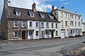
Parade House (pictured below) on the Parade is an 18th-century, grade II listed building. The Georgian house was originally an inn. The three-storey building has a hipped slate roof. [6] [42] [43]

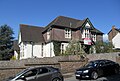
North Parade House (pictured below) at 12 North Parade is a late-18th-century, grade II listed building. It is also located on the Parade or North Parade, the segment of Monk Street north of New Dixton Road and Priory Street. The three-storey, three-bay house has a Welsh slate roof. The entrance features a radiating fanlight. The back of the property is remarkable for a large walled garden. The property was at one point the home of a wool merchant. The garage was formerly his warehouse, and the four adjacent cottages (pictured below) had provided housing for his workers. The house is located opposite the gatehouse of the Monmouth County Gaol. [1] [44] [45]

The Monmouth County Gaol (pictured below), or The Old Gaol, is a listed building. It was designed by William Blackburn and built 1788–1790. It closed in 1869 due to the increase in size of the gaol in Usk. Constructed of Old Red Sandstone, the current house is the surviving remnant of the County Gaol, and was its gatehouse. It is located opposite the North Parade House. [1] [6] [46] [47]

The former Cottage Hospital (pictured below) is an early-20th-century, listed building. It was designed by London architect Richard Creed and built in 1902. It was built on the site of the former gaol. It also has a Hereford Road address. [1] [48]

Related Research Articles

Monmouth Museum

The Monmouth Museum, alternatively known as The Nelson Museum and Local History Centre, is a museum in Monmouth, Monmouthshire, south east Wales. It features a collection of artifacts associated with Admiral Horatio Nelson. The museum is located in the old Market Hall in the town centre in Monmouth, a short distance from the River Monnow, Monmouth Castle and Agincourt Square.

North Parade House, Monmouth

North Parade House, in Monmouth Wales, dates from the late 18th century, and was refurbished in c.1800 by a wool merchant who took over the malthouse next door as a wool store, along with the cottages further up the street as housing for his workers. It has been a grade II listed building since 27 October 1965.

Priory House, Monmouth

Priory House is a Grade II Listed building in Monmouth, Wales.

Parade House, Monmouth

Parade House, is a Grade II listed building in Monk Street, Monmouth, Wales. The building is 18th-century in origin and has three storeys, gothicised windows, an ornate staircase and a hipped roof.

Monmouth War Memorial Cemetery in Monmouth, Monmouthshire

The Monmouth War Memorial commemorates the Monmouth fallen of the First and Second World Wars.

Monmouth town walls and defences

The Monmouth town walls and defences comprise the defensive system of town walls and gates built in Monmouth, Wales between 1297 and the early part of the following century. Wye Bridge Gate, East Gate, Monk's Gate, and Monnow Bridge Gate were access points to the town. West Gate, across Monnow Street, also provided access. Only the Monnow Bridge Gatehouse survives intact, albeit in a substantially modified version from the original.

Whitecross Street, Monmouth

Whitecross Street is a historic street in the town centre of Monmouth, Monmouthshire, Wales. It was in existence by the 15th century, and appears as Whit crose on the 1610 map of the town by cartographer John Speed. It runs in an east-west direction, between Church Street and St James Square. It has been suggested that the street takes its name from a plague cross. Whitecross Street is lined with numerous listed buildings.

33 Whitecross Street, Monmouth

33 Whitecross Street is a grade II listed building in Monmouth, Monmouthshire, Wales. It is in the historic St James Square neighbourhood. The property was the site of archaeological excavation in 2009, which demonstrated evidence of Neolithic (prehistoric), Roman, and Medieval activity. The following year, archaeological excavation in the square discovered the first evidence of Mesolithic human settlement in Monmouth.

Masonic Hall, Monmouth

The Masonic Hall is a grade II listed building on Monk Street in Monmouth, Monmouthshire, Wales. It was designed by architect George Vaughan Maddox. The building is believed to mark the site of Monk's Gate, part of the original defences of the town of Monmouth. Before its 1846 conversion to the Masonic Hall, the building served as the Monk Street Theatre. After more than 150 years of housing the Loyal Monmouth Lodge No. 457, the Masonic Hall sustained fire and smoke damage from suspected arson. The Lodge of Freemasons housed in the building is the oldest surviving Masonic Lodge in Monmouthshire.

Kingsley House and Hendre House, Monmouth

Kingsley House and Hendre House are a pair of 19th-century, semi-detached houses on the North Parade section of Monk Street in Monmouth, Monmouthshire, Wales. The grade II listed houses were designed by noted Monmouth architect and builder George Vaughan Maddox, who also designed at least two of the twenty-four blue plaque buildings on the Monmouth Heritage Trail, including the Market Hall and the Monmouth Methodist Church. Hendre House should be distinguished from The Hendre, the estate of the Rolls family.

St James Square, Monmouth

St James Square is a historic square in the town centre of Monmouth, Monmouthshire, Wales. It is located at the eastern end of Whitecross Street, within the medieval town walls. The area features the Monmouth War Memorial and the controversial, historic Indian Bean Tree. In addition, in 2010, the square was the site of discovery of the first Mesolithic artefacts in Monmouth. St James Square is lined with numerous listed buildings. It is also home to the Monmouth Catalpa Tree.

St James Street, Monmouth

St James Street is a historic street in the town centre of Monmouth, Monmouthshire, Wales. It appears as a segment of Whitecross Street on the 1610 map of the town by cartographer John Speed and is within the medieval town walls. On more recent maps, it extends from St James Square southwest to Almshouse Street. In 2010, the street was the site of discovery of Mesolithic era artefacts. St James Street is lined with numerous listed buildings.

St James House, Monmouth

St James House is a grade II listed building in Monmouth, Monmouthshire, Wales. It is in the historic St James Square neighbourhood, within the Medieval town walls. While the house currently has an attractive, 18th-century facade, it originated as a burgage tenement. In addition, behind the house, evidence of a kiln has been unearthed, with both Medieval and Post-medieval pottery. In 2010, archaeological excavation in the square revealed the first evidence of Mesolithic human settlement in Monmouth. Recent residents of St James House have included boarding students from Monmouth School.

Glendower Street, Monmouth

Glendower Street is a historic street in the town centre of Monmouth, Monmouthshire, Wales. It extends to the southeast from the intersection of Agincourt Street and St John's Street, within the medieval town walls. Glendower Street is lined with numerous listed buildings, including one of the 24 blue plaque buildings on the Monmouth Heritage Trail.

The Nelson Rooms, Monmouth

The Nelson Rooms is a grade II listed building in Monmouth, Monmouthshire, Wales. It is in the historic Glendower Street and Agincourt Street neighbourhood, within the medieval town walls. The building initially served as a gymnasium and was a gift from Lady Llangattock to the town of Monmouth. In 1924, after the benefactor's death, it reopened as the Nelson Museum, and showcased the collection of memorabilia related to Admiral Horatio Nelson that had been amassed by the baroness. The Nelson Museum moved to new quarters at the Market Hall in 1969. The former gymnasium and museum is now an apartment building.

Monmouth Police Station

The Monmouth Police Station is a Grade II listed building in the town centre of Monmouth, Monmouthshire, Wales. It is located in the historic Glendower Street neighbourhood, within the medieval town walls. In March 2012, it was announced that the Monmouth Police Station was one of seventeen police stations in South East Wales that would no longer be open to the public.

Druids Head Inn

The Druid's Head Inn is a grade II listed building in the town centre of Monmouth, Monmouthshire, Wales. It is located in the historic Glendower Street and Chippenhamgate Street neighbourhood, within the medieval town walls. The building served as a public house during most of its history, but for the last several decades has been the headquarters of the Monmouth Rugby Football Club.

St Johns, Monmouth

St John's is a grade II listed building in the town centre of Monmouth, Monmouthshire, Wales. It is located in the historic Glendower Street neighbourhood, within the medieval town walls. The eight bedroom home is most remarkable for the rear of the property which features a Coalbrookdale verandah and formal walled garden that have been separately grade II listed with the Cadw/ICOMOS Register of Parks and Gardens of Special Historic Interest in Wales. The villa's garden is also registered with the Welsh Historic Gardens Trust.

Wye Bridge Ward, Monmouth

Wye Bridge Ward was one of four wards in the town of Monmouth, Monmouthshire, Wales. Streets in the ward included St Mary's Street, Almshouse Street, St James Street, St James Square, Whitecross Street and Monk Street. The ward existed as a division of the town by the early seventeenth century, and continued into the twentieth century.

Great Manson Farm, Monmouth Farmhouse, Barn, Cider House in Monmouth, Wales

Great Manson Farm is a property on the northern outskirts of Monmouth, Monmouthshire, Wales, in the Buckholt area. It is in the Manson Lane neighbourhood, within the electoral division of Dixton with Osbaston. During the course of the nineteenth and twentieth centuries, members of the Clarke, Goode, Clark, Dampier, and Morgan families resided at Great Manson Farm, at which time the reported size of the farm varied from 170 to 200 acres. The property is remarkable for the presence of three grade II listed buildings, including a barn with medieval origins.

References

  1. 1 2 3 4 5 6 7 8 9 10 11 12 13 14 15 16 "Walking in Monmouth, Monmouthshire and The Wye Valley". monmouth.org.uk. The Monmouth Website. Retrieved 13 May 2012.
  2. Charles Heath (1804). Historical and descriptive accounts of the ancient and present state of the town of Monmouth. Charles Heath. p. 314. Retrieved 15 May 2012.
  3. 1 2 3 Keith Kissack (1974). Mediaeval Monmouth (illustrated ed.). Monmouth Historical and Educational Trust. p. 36.
  4. "Virtual Map of Monmouth". monmouth.org.uk. The Monmouth Website. Retrieved 14 May 2012.
  5. "House of Correction, Usk". llgc.org.uk. The Architecture of Wales - Architectural Drawings in The National Library of Wales. Archived from the original on 26 September 2012. Retrieved 14 May 2012.
  6. 1 2 3 4 5 6 7 8 John Newman (11 March 2000). Gwent/Monmouthshire (illustrated ed.). Yale University Press. p. 407. ISBN   9780300096309 . Retrieved 14 May 2012.
  7. 1 2 3 "Sanroyd House, Monmouth". britishlistedbuildings.co.uk. British Listed Buildings. Retrieved 14 May 2012.
  8. "St. James Square, 33, W. Side; Apna Gir, Whitecross St., 33". coflein.gov.uk. Royal Commission on the Ancient and Historical Monuments of Wales. Retrieved 15 May 2012.
  9. 1 2 John Newman (11 March 2000). Gwent/Monmouthshire (illustrated ed.). Yale University Press. p. 399. ISBN   9780300096309 . Retrieved 14 May 2012.
  10. "Art Gallery and Shop (former Working Men's Free Institute), Monmouth". britishlistedbuildings.co.uk. British Listed Buildings. Retrieved 14 May 2012.
  11. "jo booth - painter, printmaker". madeinmonmouthshire.com. madeinmonmouthshire. Retrieved 13 May 2012.
  12. "Baptist Chapel, Monk Street, Monmouth". coflein.gov.uk. Royal Commission on the Ancient and Historical Monuments of Wales. Retrieved 13 May 2012.
  13. "Monmouth Baptist Church, Monmouth". britishlistedbuildings.co.uk. British Listed Buildings. Retrieved 15 May 2012.
  14. "Monk Street, 5, Monmouth". coflein.gov.uk. Royal Commission on the Ancient and Historical Monuments of Wales. Retrieved 14 May 2012.
  15. "Royal George Hotel; Ivy Bank House; Ivy Bank Hotel". coflein.gov.uk. Royal Commission on the Ancient and Historical Monuments of Wales. Archived from the original on 4 March 2016. Retrieved 14 May 2012.
  16. "The Royal George Hotel, Monmouth". britishlistedbuildings.co.uk. British Listed Buildings. Retrieved 14 May 2012.
  17. "2 Bedroom Town House for Sale, Monk Street". gumtree.com. Gumtree. Retrieved 13 May 2012.
  18. "Monk Street, 6, Monmouth: Oak House". coflein.gov.uk. Royal Commission on the Ancient and Historical Monuments of Wales. Retrieved 14 May 2012.
  19. "Monk Street (East Side), 7, Monmouth; Ty Mawr". coflein.gov.uk. Royal Commission on the Ancient and Historical Monuments of Wales. Retrieved 14 May 2012.
  20. "Ty-mawr, Monmouth". britishlistedbuildings.co.uk. British Listed Buildings. Retrieved 16 May 2012.
  21. "Monk Street, 8, Monmouth; Kingsley House". coflein.gov.uk. Royal Commission on the Ancient and Historical Monuments of Wales. Retrieved 14 May 2012.
  22. "Kingsley House, Monmouth". britishlistedbuildings.co.uk. British Listed Buildings. Retrieved 13 May 2012.
  23. "Monk Street, 10, Monmouth; Hendre House". coflein.gov.uk. Royal Commission on the Ancient and Historical Monuments of Wales. Retrieved 14 May 2012.
  24. "Hendre House, Monmouth". britishlistedbuildings.co.uk. British Listed Buildings. Retrieved 14 May 2012.
  25. "Monk Street, 9, Monmouth; Sanroyd House". coflein.gov.uk. Royal Commission on the Ancient and Historical Monuments of Wales. Retrieved 14 May 2012.
  26. "Sanroyd House, Monmouth". britishlistedbuildings. British Listed Buildings. Retrieved 14 May 2012.
  27. "Masonic Hall". coflein.gov.uk. Royal Commission on the Ancient and Historical Monuments of Wales. Retrieved 15 May 2012.
  28. "The Masonic Temple, including Tyler's Residence, Monmouth". britishlistedbuildings.co.uk. British Listed Buildings. Retrieved 15 May 2012.
  29. "Monk Street Theatre". theatrestrust.org.uk. The Theatres Trust. Retrieved 13 May 2012.
  30. "Monk Street 11 Coach House". coflein.gov.uk. Royal Commission on the Ancient and Historical Monuments of Wales. Retrieved 14 May 2012.
  31. "Monk Street, 11, Monmouth; Gatehouses (The)". coflein.gov.uk. Royal Commission on the Ancient and Historical Monuments of Wales. Retrieved 14 May 2012.
  32. "The Gatehouse, Monmouth". britishlistedbuildings.co.uk. British Listed Buildings. Retrieved 14 May 2012.
  33. "Monk Street, 12, Monmouth". coflein.gov.uk. Royal Commission on the Ancient and Historical Monuments of Wales. Retrieved 14 May 2012.
  34. John Masters Lewis (1999). The Medieval Tiles of Wales (illustrated ed.). National Museum Wales. p. 239. ISBN   9780720004601 . Retrieved 13 May 2012.
  35. "Mr David Scott Sneddon". company-director-check.co.uk. DirectorCheck. Retrieved 13 May 2012.
  36. "Group of medieval floor tiles from Monmouth". gtj.org.uk. Gathering the Jewels. Retrieved 14 May 2012.
  37. "Monk Street, 13, Monmouth". coflein.gov.uk. Royal Commission on the Ancient and Historical Monuments of Wales. Retrieved 14 May 2012.
  38. "Monk Street, 14, Monmouth". coflein.gov.uk. Royal Commission on the Ancient and Historical Monuments of Wales. Retrieved 14 May 2012.
  39. "Monk Street, 16 & 18, Monmouth; Stoneleigh". coflein.gov.uk. Royal Commission on the Ancient and Historical Monuments of Wales. Retrieved 14 May 2012.
  40. "Monk Street, 20, Monmouth; Singleton House". coflein.gov.uk. Royal Commission on the Ancient and Historical Monuments of Wales. Retrieved 14 May 2012.
  41. "Chapel House, Monmouth". britishlistedbuildings.co.uk. British Listed Buildings. Retrieved 14 May 2012.
  42. "Parade House, North Parade". coflein.gov.uk. Royal Commission on the Ancient and Historical Monuments of Wales. Retrieved 15 May 2012.
  43. "Parade House, Monmouth". britishlistedbuildings.co.uk. British Listed Buildings. Retrieved 14 May 2012.
  44. "North Parade, 12, Monmouth; North Parade House". coflein.gov.uk. Royal Commission on the Ancient and Historical Monuments of Wales. Retrieved 15 May 2012.
  45. "North Parade House, Monmouth". british listed buildings. British Listed Buildings. Retrieved 14 May 2012.
  46. "Gaol, Hereford Street". coflein.gov.uk. Royal Commission on the Ancient and Historical Monuments of Wales. Retrieved 15 May 2012.
  47. "Former Gatehouse to old County Gaol, North Parade, Monmouth". britishlistedbuildings.co.uk. British Listed Buildings. Retrieved 15 May 2012.
  48. "Monmouth General Hospital, 15 Hereford Road, Monmouth". coflein.gov.uk. Royal Commission on the Ancient and Historical Monuments of Wales. Retrieved 15 May 2012.