Whitecross Street, Monmouth

Last updated

Whitecross Street, Monmouth
Old map of Monmouth, Wales.jpg
John Speed's 1610 map of Monmouth, showing Whitecross Street (marked L)
Location Monmouth, Wales
Coordinates 51°48′47″N2°42′48″W / 51.8131°N 2.7134°W / 51.8131; -2.7134
East St James Square
West Church Street

Whitecross Street is a historic street in the town centre of Monmouth, Monmouthshire, Wales. It was in existence by the 15th century, and appears as Whit crose on the 1610 map of the town by cartographer John Speed. It runs in an east-west direction, between Church Street and St James Square. It has been suggested that the street takes its name from a plague cross. Whitecross Street is lined with numerous listed buildings.

Contents

History and location

Like several other streets in Monmouth, Whitecross Street is believed to have been laid out and named by the middle of the 15th century. It is located inside the medieval walls of the town, built around 1300. Most of the street's buildings were originally based on narrow burgage plots, with gable ends facing the street. St James House in Whitecross Street, though later rebuilt, is regarded as a particularly good example of the style. [1]

On the map of Monmouth (pictured) engraved by John Speed in 1610, Whitecross Street (L on the map) is referred to as Whit crose. As discussed in a 2009 watching brief by the firm of Monmouth Archaeology, it has been assumed that the street was named after a white cross. [2] Historically, such a cross was customarily a plague cross (link to example below). It is speculated that the cross in question might be the one drawn by Speed in the churchyard of St Mary's Priory Church on his 1610 map. [2] However, according to local publisher and antiquary Charles Heath, writing in 1804, the stone cross after which the street was named was located on the site of a later public weighing machine, and its remains "were in existence in the memory of the present inhabitants." [3]

Whitecross Street is the eastward extension of the now-pedestrianised Church Street. [4] As it extends eastward and slightly to the north, the road intersects with Monk Street. Beyond the intersection, Whitecross Street continues to the east, dipping slightly to the south. It terminates at the roundabout encircling the triangular St James Square. [5] The square is remarkable for an Indian Bean Tree (Catalpa), a native of the southeastern United States. [6] [7] St James Square also features the Monmouth War Memorial, designed by W. Clarke of Llandaff and installed in front of the Catalpa in 1921. [4] [8] On some modern-day maps, the eastern leg of Whitecross Street, from the intersection with Monk Street to its termination at the roundabout encircling St James Square, is also referred to as St James Square, such that some buildings in Whitecross Street have two addresses. [9] [10]

Buildings

The Griffin (pictured below) at 1 Whitecross Street, is an 18th-century building which was grade II listed on 8 October 2005. Also referred to as The Griffin Inn, the public house is located at the corner of Whitecross Street and St Mary's Street, across from the gates of St Mary's Church. Originally The Old Griffin, it was rebuilt in the 1830s. A plaque with an image of a legendary creature, the griffin, is displayed on the facade of the building above the entrance (pictured). In addition, at the base of the pub, there is a rare hollowed sandstone gutter. [11] [12] [13]

St Mary's Priory Church (pictured below) on Whitecross Street is a Grade II* listed building. It is one of 24 blue plaque buildings on the Monmouth Heritage Trail. The main surviving medieval component of the building is the 14th-century tower. The church was rebuilt in the 18th and 19th centuries. [14] [15] [16]

5 Whitecross Street is a mid-19th-century house which is not included on the 1835 map of Monmouth by John Wood. The small, two-storey listed building has a painted exterior and a slate roof. Architectural details suggest that it was formerly a small shop. [17]

Merrick House at 6 Whitecross Street is an 18th-century listed building. The three-storey house has five windows across and a slate roof. [18]

Whitecross Street, recorded as numbers 3-11, is a listed dwelling, its record with the collection of the Royal Commission on the Ancient and Historical Monuments of Wales. [19]

13 Whitecross Street is a 19th-century listed building. The two-storey building has two windows across and a stucco on brick exterior. [20]

The Priory House (pictured below) at 15 Whitecross Street is an 18th-century grade II listed building. The three-storey building has a red tile roof. It currently serves as a private political club. [21] [22]

Whitecross House(link to photograph below) at 17 Whitecross Street is a mid-18th-century, three-storey house with five bays. The bed and breakfast is painted white with black trim and has a view of Monk Street. Whitecross House is a listed building. [4] [23] [24]

The Hollies on Whitecross Street is an 18th-century, well-preserved Georgian house which was grade II listed in 1974. Also referred to as the Holly House, the three-storey, red brick building has a slate roof. Architectural details include a moulded cornice and parapet. The interior is remarkable for its staircase. The building was listed for its architectural interest, and is located immediately behind 17 Whitecross Street. [4] [25] [26]

The Rolls Hall (pictured below) on Whitecross Street is a 19th-century Grade II listed building. It is one of 24 blue plaque buildings on the Monmouth Heritage Trail. Now the Public Library, it was built in 1887-8 of Old Red Sandstone and grey Forest of Dean ashlar. The building was a gift to the town of Monmouth by John Allan Rolls, the future Lord Llangattock. [4] [14] [27] [28] [29]

23 and 25 Whitecross Street is a pair of 19th-century listed houses. Together, there are seven bays. It is a two-storey complex, although No 23 is three-storey in part. [30]

The Judges' Lodgings at 27 Whitecross Street, just north of St James Square, is a grade II listed building. It is located opposite the public library, also known as Rolls Hall, and is one of 24 blue plaque buildings on the Monmouth Heritage Trail. The Judges' Lodgings has its origins in two adjacent 16th-century houses, which underwent extensive alterations in the 17th through 19th centuries. It was known previously as the Labour in Vain public house and Somerset House. It is also referred to as St James Garage and Mews. The three-storey, five-window section to the left has a red brick exterior. The two-storey, two window section to the right has a painted exterior. [14] [31] [32] [33]

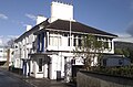
St James House (pictured below) on Whitecross Street (the address also recorded at St James Square) is an 18th-century, three-storey listed building. There are five bays and the front, red brick facade is remarkable for a tall, arched window above the entrance. The building was part of Monmouth School and was used as a boarding house. [4] [34] [35]

33 Whitecross Street (pictured below) at St James Square is a grade II listed building, most probably of the 18th century. While the front elevation is three storeys, the rear has a two-storey elevation. It was listed initially in 1974, and by Cadw in 2008, and was included due to its special architectural interest and its location amid other historic buildings. [9] [36]

Related Research Articles

<span class="mw-page-title-main">Monmouth Museum</span>

The Monmouth Museum, alternatively known as The Nelson Museum and Local History Centre, is a museum in Monmouth, Monmouthshire, south east Wales. It features a collection of artifacts associated with Admiral Horatio Nelson. The museum is located in the old Market Hall in the town centre.

<span class="mw-page-title-main">Priory House, Monmouth</span>

Priory House is a Grade II Listed building in Monmouth, Wales.

<span class="mw-page-title-main">Monmouth War Memorial</span>

The Monmouth War Memorial commemorates the Monmouth fallen of the First and Second World Wars.

<span class="mw-page-title-main">Monmouth town walls and defences</span>

The Monmouth town walls and defences comprise the defensive system of town walls and gates built in Monmouth, Wales between 1297 and the early part of the following century. Wye Bridge Gate, East Gate, Monk's Gate, and Monnow Bridge Gate were access points to the town. West Gate, across Monnow Street, also provided access. Only the Monnow Bridge Gatehouse survives intact, albeit in a substantially modified version from the original.

<span class="mw-page-title-main">33 Whitecross Street, Monmouth</span>

33 Whitecross Street is a grade II listed building in Monmouth, Wales in the area of St James Square. The property was the site of an archaeological excavation in 2009, which found evidence of Neolithic (prehistoric), Roman, and Medieval activity. The following year, archaeological excavation in the square discovered the first evidence of Mesolithic human settlement in Monmouth.

<span class="mw-page-title-main">Monk Street, Monmouth</span>

Monk Street is an historic street in the town of Monmouth, Monmouthshire, Wales. A portion of it was in existence by the 14th century, and appears on the 1610 map of the town by cartographer John Speed. It runs in a north-south direction, extending northward from its intersection with Whitecross Street. The name of the street relates to the nearby Priory, as well as the gate which was originally on this road and provided part of the town's defences, Monk's Gate. Monk Street is lined with numerous listed buildings.

<span class="mw-page-title-main">Masonic Hall, Monmouth</span>

The Masonic Hall is a grade II listed building on Monk Street in Monmouth, Monmouthshire, Wales. It was designed by architect George Vaughan Maddox. The building is believed to mark the site of Monk's Gate, part of the original defences of the town of Monmouth. Before its 1846 conversion to the Masonic Hall, the building served as the Monk Street Theatre. After more than 150 years of housing the Loyal Monmouth Lodge No. 457, the Masonic Hall sustained fire and smoke damage from suspected arson. The Lodge of Freemasons housed in the building is the oldest surviving Masonic Lodge in Monmouthshire.

<span class="mw-page-title-main">Kingsley House and Hendre House, Monmouth</span>

Kingsley House and Hendre House are a pair of 19th-century, semi-detached houses on the North Parade section of Monk Street in Monmouth, Monmouthshire, Wales. The grade II listed houses were designed by noted Monmouth architect and builder George Vaughan Maddox, who also designed at least two of the twenty-four blue plaque buildings on the Monmouth Heritage Trail, including the Market Hall and the Monmouth Methodist Church. Hendre House should be distinguished from The Hendre, the estate of the Rolls family.

<span class="mw-page-title-main">St James Square, Monmouth</span>

St James Square is a historic square in the town centre of Monmouth, Monmouthshire, Wales. It is located at the eastern end of Whitecross Street, within the medieval town walls. The area features the Monmouth War Memorial and the controversial, historic Indian Bean Tree. In addition, in 2010, the square was the site of discovery of the first Mesolithic artefacts in Monmouth. St James Square is lined with numerous listed buildings. It is also home to the Monmouth Catalpa Tree.

<span class="mw-page-title-main">St James Street, Monmouth</span>

St James Street is a historic street in the town centre of Monmouth, Monmouthshire, Wales. It appears as a segment of Whitecross Street on the 1610 map of the town by cartographer John Speed and is within the medieval town walls. On more recent maps, it extends from St James Square southwest to Almshouse Street. In 2010, the street was the site of discovery of Mesolithic era artefacts. St James Street is lined with numerous listed buildings.

<span class="mw-page-title-main">The Grange, Monmouth</span>

The Grange consists of three attached, grade II listed buildings in Monmouth, Monmouthshire, Wales. It is in the historic St James Street neighbourhood, within the medieval town walls. The Grange was originally built by Captain Charles Philipps at the site of a former farm house. It was the residence of the Kane family and, later, the Windsor family. The buildings also served as a preparatory school, one of the schools of the Haberdashers' Company, until 2009. In 2011, the buildings were converted into a boarding house for students of Monmouth School, another Haberdashers' Company school.

<span class="mw-page-title-main">St James House, Monmouth</span>

St James House is a grade II listed building in Monmouth, Monmouthshire, Wales. It is in the historic St James Square neighbourhood, within the Medieval town walls. While the house currently has an attractive, 18th-century facade, it originated as a burgage tenement. In addition, behind the house, evidence of a kiln has been unearthed, with both Medieval and Post-medieval pottery. In 2010, archaeological excavation in the square revealed the first evidence of Mesolithic human settlement in Monmouth. Recent residents of St James House have included boarding students from Monmouth School.

<span class="mw-page-title-main">Glendower Street, Monmouth</span>

Glendower Street is a historic street in the town centre of Monmouth, Monmouthshire, Wales. It extends to the southeast from the intersection of Agincourt Street and St John's Street, within the medieval town walls. Glendower Street is lined with numerous listed buildings, including one of the 24 blue plaque buildings on the Monmouth Heritage Trail.

<span class="mw-page-title-main">Nelson Rooms, Monmouth</span>

The Nelson Rooms is a grade II listed building in Monmouth, Monmouthshire, Wales. It is in the historic Glendower Street and Agincourt Street neighbourhood, within the medieval town walls. The building initially served as a gymnasium and was a gift from Lady Llangattock to the town of Monmouth. In 1924, after the benefactor's death, it reopened as the Nelson Museum, and showcased the collection of memorabilia related to Admiral Horatio Nelson that had been amassed by the baroness. The Nelson Museum moved to new quarters at the Market Hall in 1969. The former gymnasium and museum is now an apartment building.

<span class="mw-page-title-main">Monmouth Police Station</span>

The Monmouth Police Station is a Grade II listed building in the town centre of Monmouth, Monmouthshire, Wales. It is located in Glendower Street, within the medieval town walls. In March 2012, it was announced that the Monmouth Police Station was one of seventeen police stations in South East Wales that would no longer be open to the public.

<span class="mw-page-title-main">Druid's Head Inn</span>

The Druid's Head Inn is a grade II listed building in the town centre of Monmouth, Monmouthshire, Wales. It is located in the historic Glendower Street and Chippenhamgate Street neighbourhood, within the medieval town walls. The building served as a public house during most of its history, but for the last several decades has been the headquarters of the Monmouth Rugby Football Club.

<span class="mw-page-title-main">St John's, Monmouth</span>

St John's is a grade II listed building in the town centre of Monmouth, Wales. It is located in Glendower Street within the medieval town walls. The house is most remarkable for the rear of the property which features a Coalbrookdale verandah and formal walled garden that have been separately grade II listed with the Cadw/ICOMOS Register of Parks and Gardens of Special Historic Interest in Wales. The villa's garden is also registered with the Welsh Historic Gardens Trust.

<span class="mw-page-title-main">Wye Bridge Ward, Monmouth</span>

Wye Bridge Ward was one of four wards in the town of Monmouth, Monmouthshire, Wales. Streets in the ward included St Mary's Street, Almshouse Street, St James Street, St James Square, Whitecross Street and Monk Street. The ward existed as a division of the town by the early seventeenth century, and continued into the twentieth century.

<span class="mw-page-title-main">Great Manson Farm, Monmouth</span> Farmhouse, Barn, Cider House in Monmouth, Wales

Great Manson Farm is a property on the northern outskirts of Monmouth, Monmouthshire, Wales, in the Buckholt area. It is in the Manson Lane neighbourhood, within the electoral division of Dixton with Osbaston. During the course of the nineteenth and twentieth centuries, members of the Clarke, Goode, Clark, Dampier, and Morgan families resided at Great Manson Farm, at which time the reported size of the farm varied from 170 to 200 acres. The property is remarkable for the presence of three grade II listed buildings, including a barn with medieval origins.

<span class="mw-page-title-main">Gileston Manor</span>

Gileston Manor is a manor and country house located next to St Giles' Church in the small village of Gileston near St Athan, Vale of Glamorgan, Wales.

References

  1. Keith Kissack, Monmouth and its Buildings, Logaston Press, 2003, ISBN   1-904396-01-1, p.29
  2. 1 2 "Case File". idox.monmouthshire.gov.uk. monmouthshire sir fynwy. Retrieved 12 May 2012.
  3. Charles Heath, Historical and descriptive accounts of the ancient and present state of the town of Monmouth..., 1804
  4. 1 2 3 4 5 6 John Newman (11 March 2000). Gwent/Monmouthshire (illustrated ed.). Yale University Press. p. 408. ISBN   9780300096309 . Retrieved 10 May 2012.
  5. "Virtual Map of Monmouth". monmouth.org.uk. The Monmouth Website. Retrieved 11 May 2012.
  6. "Indian bean tree". bbc.co.uk. BBC. Retrieved 11 May 2012.
  7. "Council v Council in Catalpa Tree Clash". hackersons.co.uk. Monmouth Community. Retrieved 11 May 2012.
  8. "War Memorial, Monmouth". britishlistedbuildings.co.uk. British Listed Buildings. Retrieved 11 May 2012.
  9. 1 2 "St. James Square, 33, W. Side; Apna Gir, Whitecross St., 33". coflein.gov.uk. Royal Commission on the Ancient and Historical Monuments of Wales. Retrieved 11 May 2012.
  10. "Sanroyd House, Monmouth". britishlistedbuildings.co.uk. British Listed Buildings. Retrieved 14 May 2012.
  11. "Griffin Inn; 1 Whitecross Street". coflein.gov.uk. Royal Commission on the Ancient and Historical Monuments of Wales. Retrieved 11 May 2012.
  12. "The Griffin PH, Monmouth". britishlistedbuildings.co.uk. British Listed Buildings. Retrieved 10 May 2012.
  13. "The Griffin public house". geolocation.ws. Geolocation. Retrieved 11 May 2012.
  14. 1 2 3 "Monmouth Trails". visitwyevalley.com. Wye Valley & Vale of Usk. Retrieved 10 May 2012.
  15. "St Mary the Virgin, Whitecross Street, Monmouth". coflein.gov.uk. Royal Commission on the Ancient and Historical Monuments of Wales. Retrieved 11 May 2012.
  16. "Churchyard Walls, Railings, Gatepiers and Gates to south-east of Church of St. Mary, Monmouth". britishlistedbuildings.co.uk. British Listed Buildings. Retrieved 10 May 2012.
  17. "5 Whitecross Street, Monmouth". coflein.gov.uk. Royal Commission on the Ancient and Historical Monuments of Wales. Retrieved 11 May 2012.
  18. "Whitecross Street, 6; Merrick House". coflein.gov.uk. Royal Commission on the Ancient and Historical Monuments of Wales. Retrieved 11 May 2012.
  19. "Whitecross Street, 3-11". coflein.gov.uk. Royal Commission on the Ancient and Historical Monuments of Wales. Retrieved 11 May 2012.
  20. "Whitecross Street, 13". coflein.gov.uk. Royal Commission on the Ancient and Historical Monuments of Wales. Retrieved 11 May 2012.
  21. "Priory House Conservative Club, Monmouth". britishlistedbuildings.co.uk. British Listed Buildings. Retrieved 10 May 2012.
  22. "Whitecross Street, 15; Priory House-Conservative Club". coflein.gov.uk. Royal Commission on the Ancient and Historical Monuments of Wales. Retrieved 10 May 2012.
  23. "Whitecross Street, 17; Whitecross House". coflein.gov.uk. Royal Commission on the Ancient and Historical Monuments of Wales. Retrieved 11 May 2012.
  24. "Bed and breakfast entry". offasdyke.demon.co.uk. Offa's Dyke Association. Retrieved 11 May 2012.
  25. "Hollies The; Holly House, Whitecross Street". coflein.gov.uk. Royal Commission on the Ancient and Historical Monuments of Wales. Retrieved 11 May 2012.
  26. "Holly House, Monmouth". britishlistedbuildings.co.uk. British Listed Buildings. Retrieved 21 May 2012.
  27. "Rolls Hall". coflein.gov.uk. Royal Commission on the Ancient and Historical Monuments of Wales. Retrieved 11 May 2012.
  28. "Monmouth Public Library (formerly Rolls Hall), Monmouth". britishlistedbuildings.co.uk. British Listed Buildings. Retrieved 10 May 2012.
  29. "Libraries - Monmouth Library reopens". libraries.monmouthshire.gov.uk. Monmouthshire Libraries & Information Service. Retrieved 10 May 2012.
  30. "Whitecross Street, 23 & 25". coflein.gov.uk. Royal Commission on the Ancient and Historical Monuments of Wales. Retrieved 11 May 2012.
  31. "St. James Square, House in; St. James Square - Garage; 3, St James Mews". coflein.gov.uk. Royal Commission on the Ancient and Historical Monuments of Wales. Retrieved 11 May 2012.
  32. "Whitecross Street No 27, Monmouth; St. James' Garage and Mews; Labour in Vain Public House". coflein.gov.uk. Royal Commission on the Ancient and Historical Monuments of Wales. Retrieved 11 May 2012.
  33. "No.27, St. James' Garage (front range only), Whitecross Street, Monmouth". britishlistedbuildings.co.uk. British Listed Building. Retrieved 10 May 2012.
  34. "St. James's House, 10 St James's Square". coflein.gov.uk. Royal Commission on the Ancient and Historical Monuments of Wales. Retrieved 11 May 2012.
  35. "St James House, Monmouth". geograph.org.uk. geograph. Retrieved 11 May 2012.
  36. "Apria Gir, Monmouth". britishlistedbuildings.co.uk. British Listed Buildings. Retrieved 13 May 2012.