Mont Sainte-Odile

Last updated
Mont Sainte-Odile
German: 'Odilienberg'
Ottrott Mont Sainte-Odile.JPG
Mont Sainte-Odile and the Monastery
Highest point
Elevation 764 m (2,507 ft) [1]
Coordinates 48°26′15″N7°24′16″E / 48.4374580°N 7.4044908°E / 48.4374580; 7.4044908
Geography
France relief location map.jpg
Red triangle with thick white border.svg
Mont Sainte-Odile
France
Location Alsace, France
Parent range Vosges Mountains
Monastery at Mont Sainte-Odile Alsace Mont Sainte-Odile 02.JPG
Monastery at Mont Sainte-Odile
Fountain Sainte-Odile Le Mont Ste. Odile (Odilienberg) jm3809.jpg
Fountain Sainte-Odile
Section of the Pagan Wall Odilienberg heidenmauer.jpg
Section of the Pagan Wall
Site of Mont Sainte-Odile air crash of 20 January 1992 Site crash Mont Sainte-Odile 1992.jpg
Site of Mont Sainte-Odile air crash of 20 January 1992

Mont Sainte-Odile (German : 'Odilienberg' or Ottilienberg; called Allitona in the 8th century) is a 764-metre-high peak in the Vosges Mountains in Alsace in France, immediately west of Barr. The mountain is named after Saint Odile. It has a monastery/convent at its top called the Hohenburg Abbey, and is notable also for its stone fortifications called "the Pagan Wall." In 1992, Air Inter Flight 148 crashed near this area.

Contents

History

The mountain and its surroundings contain evidence of Celtic settlements. The mountain enters recorded history during the Roman times; a fortress was supposedly destroyed by the Vandals in 407. [2] In the second half of the 9th century, when Vikings attacked the Low Countries, which had been recently converted to Christianity and were governed from Utrecht, the Utrecht bishops went into exile and stayed for a while in Mont Sainte-Odile. [3]

At least since the 19th century, its beauty has been celebrated [4] and the mountain, with convent and pagan wall, is often included in tourist guides, [5] incl. Baedeker's. [6]

Hohenburg Abbey

The convent is said to have been founded by Adalrich, Duke of Alsace, in honor of his daughter, Saint Odile, about the end of the 7th century, and it is certain that it existed at the time of Charlemagne. Destroyed during the Middle Ages, it was rebuilt by Premonstratensians at the beginning of the 17th century. It was acquired later by the bishop of Strasbourg, who restored the building and the adjoining church in 1853. [7]

A famous manuscript, the Hortus Deliciarum , was compiled in the convent.

The Pagan Wall

The Pagan Wall (German : Heidenmauer, French : Mur païen) is a huge construction about 10 kilometres (6.2 mi) long which encircles Mont Sainte Odile. It is composed of about 300,000 blocks, between 1.6 metres (5.2 ft) and 1.8 metres (5.9 ft) wide and up to 3 metres (9.8 ft) high. The origins and date were disputed for a long time, with some claiming that it was a 3,000-year-old druid construction. Recent research has shown that it dates from the 7th century, about the time that the convent was built. [8] The designation "Pagan" is attributed to Pope Leo IX.

Airbus crash

At 7:20 pm on 20 January 1992, Air Inter Flight 148, an Airbus A320, crashed on a ridge near Mont Sainte-Odile. There were 87 casualties and 9 survivors.

In art and literature

A 2000 poem, "Return to St. Odilienberg, Easter 2000," by the American poet Claire Nicholas White, is inspired by the abbey. [9]

See also

Related Research Articles

<span class="mw-page-title-main">Bas-Rhin</span> Department of France

Bas-Rhin is a département in Alsace which is a part of the Grand Est super-region of France. The name means 'Lower Rhine', referring to its lower altitude among the two French Rhine departments: it is downstream of the Haut-Rhin department. Note that both belong to the European Upper Rhine region. It is, with the Haut-Rhin, one of the two departments of the traditional Alsace region which until 1871, also included the area now known as the Territoire de Belfort. The more populous and densely populated of the pair, it had 1,148,073 inhabitants in 2020. The prefecture is based in Strasbourg. The INSEE and Post Code is 67.
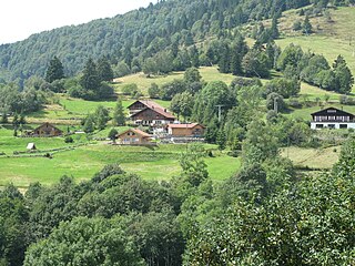
<span class="mw-page-title-main">Vosges</span> Mountain range in France

The Vosges are a range of low mountains in Eastern France, near its border with Germany. Together with the Palatine Forest to the north on the German side of the border, they form a single geomorphological unit and low mountain range of around 8,000 km2 (3,100 sq mi) in area. It runs in a north-northeast direction from the Burgundian Gate to the Börrstadt Basin, and forms the western boundary of the Upper Rhine Plain.

<span class="mw-page-title-main">Odile of Alsace</span> Abbess and Roman Catholic saint

Odile of Alsace, also known as Odilia and Ottilia, born c. 662 - c. 720 at Mont Sainte-Odile), is a saint venerated in the Catholic Church and the Eastern Orthodox Church. She is a patroness saint of good eyesight and of the region of Alsace.

<span class="mw-page-title-main">Munster cheese</span> French soft and pungent cheese

Munster, Munster-géromé, or (Alsatian) Minschterkaas, is a soft cheese with a subtle taste, made mainly from milk first produced in the Vosges, between the Alsace-Lorraine and Franche-Comté regions in France. The name "Munster" is derived from the Alsace town of Munster, where, among Vosgian abbeys and monasteries, the cheese was conserved and matured in monks' cellars.

<span class="mw-page-title-main">Remiremont</span> Commune in Grand Est, France

Remiremont is a town and commune in the Vosges department, northeastern France, situated in southern Grand Est. The town has been an abbatial centre since the 7th century, is an economic crossroads of the Moselle and Moselotte valleys, and is also a stepping stone for tourists wishing to explore the Vosges and neighbouring Alsace. Remiremont has got a police station, which covers the city and his suburban area. The fire station realizes more than 2000 interventions per year. Remiremont is also known as the La Belle des Vosges.

<span class="mw-page-title-main">Rosheim</span> Commune in Grand Est, France

Rosheim is a commune in the Bas-Rhin department in Grand Est in north-eastern France.

<span class="mw-page-title-main">Sainte-Marie-aux-Mines</span> Commune in Grand Est, France

Sainte-Marie-aux-Mines is a commune in the Haut-Rhin department and Grand Est region of north-eastern France.

<span class="mw-page-title-main">Mont Sainte-Odile Abbey</span> Abbey in Bas-Rhin, in France

Mont Sainte-Odile Abbey, also known as Hohenburg Abbey, is a nunnery, situated on Mont Sainte-Odile, one of the most famous peaks of the Vosges mountain range in the French region of Alsace.

<span class="mw-page-title-main">Andlau</span> Commune in Grand Est, France

Andlau is a commune in the Bas-Rhin department in Alsace, Grand Est region of northeastern France.

<span class="mw-page-title-main">Barr, Bas-Rhin</span> Commune in Grand Est, France

Barr is a commune in the Bas-Rhin department in the Alsace region of north-eastern France.

<span class="mw-page-title-main">Gertwiller</span> Commune in Grand Est, France

Gertwiller is a commune in the Bas-Rhin department in Alsace in north-eastern France.

<span class="mw-page-title-main">Fouday</span> Commune in Grand Est, France

Fouday is a commune in the Bas-Rhin department in Grand Est in north-eastern France.

<span class="mw-page-title-main">Neuwiller-lès-Saverne</span> Commune in Grand Est, France

Neuwiller-lès-Saverne is a commune located in the historic and cultural region of Alsace and the Northern Vosges Regional Nature Park in northeastern France. Neuwiller-lès-Saverne is within the Bas-Rhin department in the Grand Est region, and since 2021, is part of the European Collectivity of Alsace territorial collective. The commune is also a member of the Hanau-La Petite Pierre commune community.

<span class="mw-page-title-main">Taennchel</span>

The Taennchel is one of the summits of the Vosges Mountains, rising to 988 metres (3,241 ft). The Taennchel rises at the East of France, in the département of Haut-Rhin, halfway between Strasbourg to the North and Mulhouse to the South, around 60 km (40 mi) from both cities.

<span class="mw-page-title-main">Neubourg Abbey</span>

Neubourg Abbey is a former Cistercian monastery in Alsace, France, in Dauendorf, about 9 km west of Haguenau in the Bas-Rhin department.

<span class="mw-page-title-main">St. Faith's Church, Sélestat</span> Church in Sélestat, France

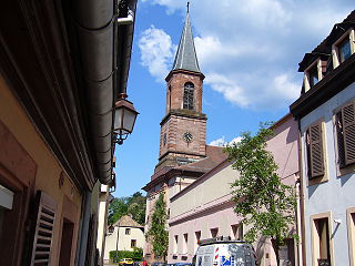
The Church of Saint Faith of Sélestat is a major Romanesque architecture landmark in Sélestat along the Route Romane d'Alsace in the East of France. The church having been built over a very short time span, it appears strikingly homogenous in style and proportions, however some parts have been completed and others modified in a Romanesque Revival style by the architect Charles Winckler between 1889 and 1893. During that restoration campaign, a crypt dating back to around 1085 was discovered and made accessible as well. Like many major buildings in Alsace the church is made of pink Vosges mountains sandstone.

<span class="mw-page-title-main">Château de Dreistein</span>

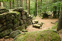
The Château de Dreistein is a ruined castle in the commune of Ottrott in the Bas-Rhin département of France. It is, in fact, three separate castles built on rocky promontories, hence the name drei Stein, "three stones" in medieval German.

<span class="mw-page-title-main">Château du Hagelschloss</span>

The Château du Hagelschloss is a ruined castle in the commune of Ottrott in the Bas-Rhin département of France. It was constructed in the 13th century.

<span class="mw-page-title-main">Niedermunster Abbey, Alsace</span>

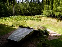
Niedermunster Abbey, situated at the foot of Mount Saint Odile at an altitude of 511 metres, was founded around 700 A.D. to cater for the overflow of pilgrims to the Saint Odile Abbey, formerly known as the Hohenbourg.

<span class="mw-page-title-main">Eugénie d'Alsace</span> French saint and abbess

Eugénie of Alsace, was the second abbess of the Hohenburg Abbey, in Alsace, France, from 721 to 735, and she was later made a Roman Catholic saint. She was a niece of Saint Odile and sister of Saint Attalus. Saint Eugénie's feast day is celebrated on 16 September, which was the day she died of natural causes in 735 in Hohenburg.

References

  1. Official maps of IGN available on the Géoportail .
  2. Lee, Katharine (1883). In the Alsatian Mountains: A Narrative of a Tour in the Vosges. London: Richard Bentley. pp. 149–50.
  3. "Utrecht," in Jeep, John M. (2001). Medieval Germany: An Encyclopedia. Routledge. p. 775. ISBN   978-0-8240-7644-3.
  4. Lee, Katharine (1883). In the Alsatian Mountains: A Narrative of a Tour in the Vosges. London: Richard Bentley. pp. 154–56.
  5. Ardouin-Dumazet, Victor Eugène (1907). Voyage en France. Berger-Levrault, 1907. pp. 191–92.
  6. The Rhine, including the Black Forest & the Vosges: handbook for travellers. Karl Baedeker. 1911. p. 511.
  7. Wikisource-logo.svg One or more of the preceding sentences incorporates text from a publication now in the public domain :  Chisholm, Hugh, ed. (1911). "Odilienberg". Encyclopædia Britannica . Vol. 20 (11th ed.). Cambridge University Press. p. 4.
  8. Châtelet, Madeleine. "CHÂTELET M., BAUDOUX J., 2016, Le « Mur païen » du Mont Sainte-Odile en Alsace : un ouvrage du haut Moyen Âge ? L'apport des fouilles archéologiques". Zeitschrift für Archäologie des Mittelalters.
  9. Creeley, Robert; David Lehmann (2002). The Best American Poetry 2002. Charles Scribner's Sons. pp. 176–223. ISBN   978-0-7432-0385-2.