
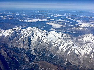
The Pyrenees are a mountain range straddling the border of France and Spain. They extend nearly 500 km (310 mi) from their union with the Cantabrian Mountains to Cap de Creus on the Mediterranean coast, reaching a maximum altitude of 3,404 metres (11,168 ft) at the peak of Aneto.

Mont Blanc is the highest mountain in the Alps and Western Europe, and the highest mountain in Europe outside the Caucasus Mountains, rising 4,805.59 m (15,766 ft) above sea level, located on the Franco-Italian border. It is the second-most prominent mountain in Europe, after Mount Elbrus, and the 11th most prominent mountain in the world.

Ariège is a department in southwestern France, located in the region of Occitanie. It is named after the river Ariège and its capital is Foix. Ariège is known for its rural landscape, with a population of 153,287 as of 2019. Its INSEE and postal code is 09, hence the department's informal name of le zéro neuf. The inhabitants of the department are known as Ariègeois or Ariègeoises.

Aneto is the highest mountain in the Pyrenees and in Aragon, and Spain's third-highest mountain, reaching a height of 3,404 metres. It stands in the Spanish province of Huesca, the northernmost of the three Aragonese provinces, 6 kilometres south of the France–Spain border. It forms the southernmost part of the Maladeta massif.

The Aiguille de Bionnassay is a mountain in the Mont Blanc massif of the Alps in France and Italy. It has been described as "one of the most attractive satellite peaks of Mont Blanc", and is located on its western side. The mountain's south and east ridges form the frontier between the two countries, and its summit is a knife-edge crest of snow and ice. Reaching it via any route provides a "splendid and serious snow and ice climb".
Couserans is a former county of France located in the Pyrenees mountains. Today Couserans makes up the western half of the Ariège département, around the towns of Saint-Girons and Saint-Lizier. A small part of Couserans is also in the extreme south of Haute-Garonne, just across the border from Ariège.

Monte Rosa is a mountain massif in the eastern part of the Pennine Alps, on the border between Italy and Switzerland (Valais). The highest peak of the massif, amongst several peaks of over 4,000 m (13,000 ft), is the Dufourspitze, the second highest mountain in the Alps and western Europe, after Mont Blanc. The east face of the Monte Rosa towards Italy has a height of about 2,400 metres (7,900 ft) and is the highest mountain wall of the Alps.

The Barre des Écrins is a mountain in the French Alps with a peak elevation of 4,102 metres (13,458 ft). It is the highest peak of the Massif des Écrins and the Dauphiné Alps and the most southerly alpine peak in Europe that is higher than 4,000 metres. It is the only 4,000-metre mountain in France that lies outside the Mont Blanc Massif. Before the annexation of Savoy in 1860 it was the highest mountain in France.

Monte Perdido is the third highest mountain in the Pyrenees. The summit of Monte Perdido (3355 m), located in Spain, lies hidden from France by the seemingly impenetrable peaks of the Cirques of Gavarnie and Estaubé. It stands in the north of Huesca province. The mountain forms part of the Monte Perdido Range and is located in the Ordesa y Monte Perdido National Park, in the western part of the Pyrenees, in the community of Aragon, Spain.

Saint-Lizier is a commune in the Ariège department in southwestern France, situated on the river Salat.

The arrondissement of Saint-Girons is an arrondissement of France in the Ariège department in the Occitanie region. It has 121 communes. Its population is 41,017 (2021), and its area is 2,019.3 km2 (779.7 sq mi).
The Mont Blanc massif is a mountain range in the Alps, located mostly in France and Italy, but also straddling Switzerland at its northeastern end. It contains eleven major independent summits, each over 4,000 metres (13,123 ft) in height. It is named after Mont Blanc, the highest point in western Europe and the European Union. Because of its considerable overall altitude, a large proportion of the massif is covered by glaciers, which include the Mer de Glace and the Miage Glacier – the longest glaciers in France and Italy, respectively.

The Salat is a river in southern France, a right tributary of the Garonne. It is 74.1 km (46.0 mi) long. It rises in nine points above the hamlet Salau in the municipality Couflens, on the slopes of Mont Rouch, central Pyrenees. The former Gascon province of Couserans is based on its valley.

GR 10 is a French GR footpath, or hiking trail, that runs the length of the Pyrenees Mountains. It roughly parallels the French–Spanish border on the French side. Those attempting the entire trail often choose to walk it from west to east, from Hendaye on the Bay of Biscay to Banyuls-sur-Mer on the Mediterranean Sea, but it can also be traversed east to west.

Arrout is a commune in the Ariège department in the Occitanie region of south-western France.

Audressein is a commune in the Ariège department in the Occitanie region of south-western France.
Aulus-les-Bains is a commune in the Ariège department in the Occitanie region of south-western France.

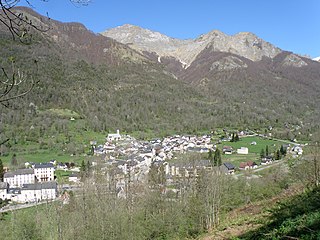
Montjoie-en-Couserans is a commune in the Ariège department in southwestern France, in the northwest of the Ariège department, in the Occitanie region. Historically and culturally, the town is part of Couserans, an area with Gascon roots structured by the course of the Salat.
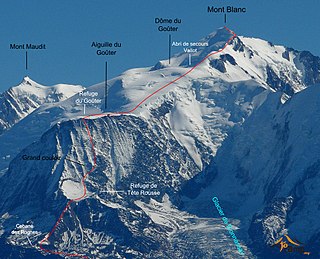
The Goûter Route is one of the two normal mountaineering routes used to reach the summit of Mont Blanc in the Alps, ascending to a height of 4,808 metres (15,774 ft). The route lies on the north side of the mountain, in France. Usually reckoned as the easiest route up Mont Blanc, it is extremely popular with mountaineers, seeing thousands of ascents per year.

The Aiguille de la Brenva is a remote rocky mountain peak in the Mont Blanc massif of the Alps. It lies wholly within Italy on a ridge descending south-east from the Tour Ronde. It has been described as "a spectacular fin with a fine E face". It stands on a ridge separating the Entrèves glacier from the Brenva glacier, yet is somewhat overshadowed by its larger neighbours, such as the Aiguille Blanche and the Aiguille Noire de Peuterey. Nevertheless, it is a distinctive peak, offering a number of very challenging climbs, especially on its east face which consists of vertical granite flakes and cracks. On its northern side stands a distinctive, slender rock pinnacle about 60 metres high, known as the Père Eternel.


