Mont d'Or (Jura Mountains)

Last updated
Mont d'Or
Falaise du Mont d'Or 2.jpg
View from the crest towards the south
Highest point
Elevation 1,463 m (4,800 ft)
Prominence 368 m (1,207 ft) [1]
Parent peak Crêt de la Neige
Isolation 4.8 km (3.0 mi) [2]
Coordinates 46°43′39″N06°21′25″E / 46.72750°N 6.35694°E / 46.72750; 6.35694 Coordinates: 46°43′39″N06°21′25″E / 46.72750°N 6.35694°E / 46.72750; 6.35694
Geography
France relief location map.jpg
Red triangle with thick white border.svg
Mont d'Or
Location in France
Location Doubs, France
(mountain partially in Switzerland)
Parent range Jura Mountains

Mont d'Or (French: Le Mont d'Or) is a mountain of the Jura, located in the French department of Doubs and extending into the Swiss canton of Vaud. Its main summit is 1,463 metre-high and lies within France, 500 metres north of the border with Switzerland (1,380 m). The mountain is located between Jougne, France and Vallorbe, Switzerland.

Contents

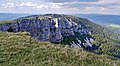
Mont d'Or is notable for its limestone cirque on the east side. Near the highest point of the Swiss border is the Cabane du Mont d'Or, a mountain hut owned by the Swiss Alpine Club. In winter, Mont d'Or also includes a ski area within France. Several ski lifts are located on both west and east sides of the mountain.

Related Research Articles

Diablerets

The Diablerets are a huge ice-covered mountain massif of the Alps, culminating at the Sommet des Diablerets at 3,210 metres (10,530 ft) above sea level and straddling the border between the Swiss cantons of Vaud (VD) and Valais (VS). The northeastern part of the massif stretches also into the canton of Bern (BE).

Grand Combin

The Grand Combin is a mountain massif in the western Pennine Alps in the canton of Valais. At a height of 4,314 metres (14,154 ft) the summit of Combin de Grafeneire is one of the highest peaks in the Alps and the second most prominent of the Pennine Alps. The Grand Combin is also a large glaciated massif consisting of several summits, among which three are above 4000 metres. The highest part of the massif is wholly in Switzerland, although the border with Italy lies a few kilometres south.

Titlis

Titlis is a mountain of the Uri Alps, located on the border between the cantons of Obwalden and Bern. At 3,238 metres (10,623 ft) above sea level, it is the highest summit of the range north of the Susten Pass, between the Bernese Oberland and Central Switzerland. It is mainly accessed from Engelberg (OW) on the north side and is famous as the site of the world's first rotating cable car. The cable car system connects Engelberg to the summit of Klein Titlis through the three stages of Gerschnialp, Trübsee and Stand.

La Dôle

La Dôle is a mountain of the Jura, overlooking Lake Geneva in the westernmost part of the canton of Vaud. Rising to an altitude of 1677 meters, it is the second highest peak in the Swiss portion of the Jura, after Mont Tendre. Administratively, the summit is split between the municipalities of Gingins, Chéserex and La Rippe. The mountain is also close to and easily accessible from Saint-Cergue and the Col de la Givrine to the north, both above 1000 meters and connected to Nyon on Lake Geneva by road and by the Nyon–St-Cergue–Morez Railway. A paved road also climbs to the Chalet de la Dôle below the summit from Gingins.

Mont Dolent Mountain in the Mont Blanc massif

Mont Dolent is a mountain in the Mont Blanc massif and lies on the border between Italy, Switzerland and France.

Vanil Noir

The Vanil Noir is a mountain of the Fribourg Prealps, located on the border between the cantons of Fribourg and Vaud in western Switzerland. Reaching a height of 2,389 metres above sea level, the Vanil Noir is the highest summit of the canton of Fribourg and of the Alpine foothills lying north of the Saane and Simme. It is also the northernmost point in the canton of Vaud above 2,300 metres and the most prominent summit of both cantons.

Mont Fort

Mont Fort is a mountain of the Pennine Alps, located near Verbier in the Swiss canton of Valais. It lies on the range between the valleys of Bagnes and Nendaz, north of the Rosablanche. With a height of 3,328 metres above sea level, Mont Fort is the highest summit north of the Col de Louvie.

Cornettes de Bise

The Cornettes de Bise is a mountain in the Chablais Alps, overlooking Lake Geneva. At 2,432 metres above sea level, it is the highest summit of the subrange running from Pas de Morgins to Lake Geneva. The mountain is located on the border between France (west) and Switzerland (east).

Aiguille du Tour

The Aiguille du Tour is a mountain in the Mont Blanc massif, located on the border between Switzerland and France. The voie normale on the mountain is graded F (facile) and can be climbed from either the Albert Premier Hut on the French side or the Trient Hut on the Swiss side.

Pointe des Grands

The Pointe des Grands is a mountain of the Mont Blanc Massif, located on the border between France and Switzerland, north-west of the Aiguille du Tour.

Les Grandes Otanes

Les Grandes Otanes are a mountain of the Mont Blanc Massif, located on the border between Switzerland and France, north of the Aiguille du Tour. They overlook the Col de Balme.

Mont Raimeux

Mont Raimeux is a mountain of the Jura range, located on the border between the Swiss cantons of Jura and Berne. Reaching a height of 1,302 metres above sea level, it is the highest summit in the canton of Jura.

Mont Pèlerin Mountain of the Swiss Plateau

Mont Pèlerin is a mountain of the Swiss Plateau, overlooking Lake Geneva in the canton of Vaud. It lies north of Chardonne, over Vevey, the border with the canton of Fribourg running at the eastern foot of the mountain.

Pointe de la Plaine Morte

The Pointe de la Plaine Morte is a mountain of the Bernese Alps, located on the border between the Swiss cantons of Bern and Valais. It overlooks the large and flat glacier named Plaine Morte Glacier, from the south-west side.

Le Noirmont (mountain)

Le Noirmont is a mountain of the Jura, located north of Saint-Cergue in the canton of Vaud. At 1,567 metres, it is the highest mountain between the Col de la Givrine and Mont Tendre. Although Le Noirmont is wholly in Switzerland, the border with France runs on the western base of the mountain.

Mont Risoux

Mont Risoux is a large wooded crest of the Jura Mountains, located between France and Switzerland. The culminating point, lying on the border between the department of Doubs and the canton of Vaud, is named Gros Crêt.

Mont Vully

Mont Vully is a hill of the Swiss Plateau, located between Lake Morat and Lake Neuchâtel in the canton of Fribourg, east of the border with the canton of Vaud.

Niremont

The Niremont is a mountain of the Swiss Prealps, in the canton of Fribourg. Due to its rounded shape, it has 2 sub-summits : The Gros Niremont and the Petit Niremont.

Pic de Tenneverge

Pic de Tenneverge is a mountain of the Chablais Alps, located between the French department of Haute-Savoie and the Swiss canton of Valais. Its summit is 2,985 metre-high and lies within France, 300 metres west of the border with Switzerland. The mountain is located between Sixt-Fer-à-Cheval (France) and Lac d'Emosson (Switzerland).

References

  1. Retrieved from the Swisstopo topographic maps. The key col is located north of Les Rousses at 1,095 metres.
  2. Retrieved from the Swisstopo topographic maps. The nearest point of higher elevation is north of the Dent de Vaulion

Commons-logo.svg Media related to Mont d'Or (Doubs) at Wikimedia Commons