
Quincy is a coastal U.S. city in Norfolk County, Massachusetts, United States. It is the largest city in the county and a part of Metropolitan Boston as one of Boston's immediate southern suburbs. Its population in 2020 was 101,636, making it the seventh-largest city in the state. Known as the "City of Presidents", Quincy is the birthplace of two U.S. presidents—John Adams and his son John Quincy Adams—as well as John Hancock, the first signer of the Declaration of Independence and the first and third governor of Massachusetts.

Roslindale is a primarily residential neighborhood of Boston, Massachusetts, bordered by Jamaica Plain, Hyde Park, West Roxbury and Mattapan. It is served by an MBTA Commuter Rail line, several MBTA bus lines and the MBTA Orange Line in nearby Jamaica Plain. Roslindale has its own branch of the Boston Public Library, the neighborhood is covered by Boston Police District E-5 in West Roxbury, Boston EMS Ambulance 17 is stationed in Roslindale, and the Boston Fire Department has a station on Canterbury Street which houses Ladder 16, Engine 53 & District Chief 12. Roslindale's original Engine Company 45, was deactivated on April 10, 1981, due to budget cuts. Roslindale was once called the "garden suburb" of Boston. The portion of the Arnold Arboretum south of Bussey Street is located in Roslindale.

Wollaston, Massachusetts, is a neighborhood in the city of Quincy, Massachusetts. Divided by Hancock Street or Route 3A, the Wollaston Beach side is known as Wollaston Park, while the Wollaston Hill side is known as Wollaston Heights.

Ashmont is a section of the Dorchester neighborhood of Boston. It includes the subsections of Ashmont Hill, Peabody Square, and Ashmont-Adams. Located near the Milton/Boston border, major streets include Ashmont Street, Gallivan Blvd., and Dorchester Avenue.

Wood Island station is a MBTA Blue Line rapid transit station located off Bennington Street in the Day Square section of East Boston, Boston, Massachusetts. The station is adjacent to and named for the former Wood Island Park, a once heavily used recreational area for East Boston residents. Most of the park was destroyed in the mid 1960s to expand Logan International Airport. It was built in 1952, replacing a pair of Boston, Revere Beach and Lynn Railroad stations that served the area.

North Quincy station is an MBTA subway Red Line station in Quincy, Massachusetts. It is located in North Quincy, off Hancock Street. A major park-and-ride stop, it has over 1200 parking spaces for commuters. The station is fully accessible.
Maverick Square is a section of the neighborhood of East Boston in Boston, Massachusetts, United States. It is East Boston's oldest commercial center. At the heart of the square is Maverick Station, which is part of the Blue Line of the MBTA.

Houghs Neck is a one-square-mile (2.6 km2) peninsula in Quincy, Massachusetts. It is surrounded by Quincy Bay, Hingham Bay and Rock Island Cove. It is lined by Perry Beach, which runs along Manet Avenue; Nut Island, which is just beyond Great Hill at the very end of the peninsula; and Edgewater Drive.
North Quincy is a neighborhood of Quincy, Massachusetts. It is separated from the city of Boston by the Neponset River, and borders the Quincy neighborhoods of Squantum, Montclair and Wollaston. It contains the smaller neighborhoods of Atlantic and Norfolk Downs, as well as much of Wollaston Beach.
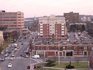
Quincy Center is an area of Quincy, Massachusetts, centered along Hancock Street and covering the downtown area of the city. The area is a retail shopping locale and also includes the City Hall, the Thomas Crane Public Library, several churches, including the United First Parish Church, where John Adams and John Quincy Adams were buried, and numerous office buildings, including the headquarters of Stop & Shop. A memorial to the soldiers of World War I along with various statues of other great figures can be found in the vicinity. It is served by a large Massachusetts Bay Transportation Authority (MBTA) station which includes subway access and bus services.

Downtown Boston is the central business district of Boston, Massachusetts, United States. Boston was founded in 1630. The largest of the city's commercial districts, Downtown is the location of many corporate or regional headquarters; city, county, state and federal government facilities; and many of Boston's tourist attractions. Similar to other central business districts in the U.S., Downtown has recently undergone a transformation that included the construction of new condos and lofts, renovation of historic buildings, and arrival of new residents and businesses. It is represented in the Boston City Council by District 2's Bill Linehan.

Uphams Corner, or Upham's Corner, is a commercial center in Dorchester, the largest neighborhood of Boston, Massachusetts. The intersection of Dudley Street/Stoughton Street and Columbia Road is the heart of Uphams Corner, and one of Dorchester's main business districts.
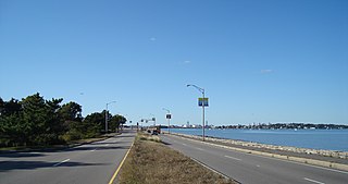
Quincy Shore Drive is a historic parkway in Quincy, Massachusetts. The road is one of a series of parkways built by predecessors of the Massachusetts Department of Conservation and Recreation, to provide access to parks and beaches in the Greater Boston area. Its development was proposed in 1893 by Charles Eliot, who promoted the development of many of the area's parks and parkways. Planning began in 1897, with land acquisition following around 1900. Construction of the 4-mile (6.4 km) road was begun in 1903 and completed in 1907.
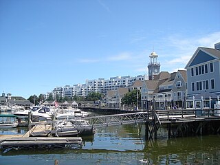
Marina Bay is a mixed-use development neighborhood of condominium, commercial and entertainment facilities in Quincy, Massachusetts. It includes five housing complexes and one assisted living complex, office complexes, numerous restaurants, a craft brewery and taproom, a 685-slip marina and a seaside boardwalk. It is situated on the northwestern part of Squantum Peninsula at the mouth of the Neponset River where it meets Dorchester Bay in Boston Harbor. The permanent residential population of Marina Bay in 2000 was about 1,300 according to the United States Census Bureau,; however, the Boston Globe reported in 2004 that the complex had 2,000 residents.
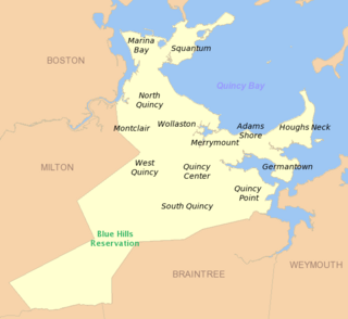
South Quincy is a neighborhood of Quincy, Massachusetts. Located in the south central portion of the city, South Quincy is bordered on the north by Quincy Center and West Quincy, on the east by Quincy Avenue and the Quincy Point neighborhood, on the south by Braintree and on the west by Interstate 93.

Squantum is a neighborhood of Quincy, Massachusetts, connected to the mainland by a causeway that crosses over a wetland area of the bay. Often thought of as a peninsula, Squantum proper is technically a barrier island as it is surrounded on all four sides by water and is only connected to the mainland and Moon Island via causeways. Located in the northernmost portion of the city, Squantum is bordered on the north by Dorchester Bay and Boston Harbor, on the east by Moon Island and Quincy Bay, on the south by Quincy Bay and North Quincy, and on the west by the Marina Bay development. The population of the neighborhood in 2010 according to the United States Census Bureau was 2,365. Squantum has scenic, waterfront views of Boston Harbor and the Boston skyline and has many of Quincy’s most expensive homes. Squantum residents are the wealthiest of any neighborhood in Quincy, according to the 2010 United States Census Bureau, and the home ownership rate is approximately 92%. The neighborhood is further characterized by its tree-lined streets, its "island getaway" feel, close-knit community, and its annual Squantum Fourth of July Parade. As described in a 2020 book, "One road leads in and out of a square mile of land that is a playground for children and a haven for adults." Squantum also has one of the largest Irish populations, on a per capita basis, of any neighborhood in the United States.
West Quincy is a neighborhood of Quincy, Massachusetts. It is bordered on the north by Wollaston, on the east by Quincy Center, on the south by South Quincy and on the west by the town of Milton and the Blue Hills Reservation.

Union Square is a square in the Allston neighborhood of Boston, Massachusetts at the intersection of Cambridge Street and Brighton Avenue/North Beacon Street. Union Square is serviced by the MBTA 57, 64, 66, 501, and 503 buses. There is also a station for the Blue Bikes bicycle sharing system in Union Square.
Brigham Circle is located at the intersection of Tremont Street and Huntington Avenue in the Mission Hill neighborhood of Boston, Massachusetts. The commercial center of Mission Hill, it forms the southern tip of the Longwood Medical Area.

Parkway is a section of the West Roxbury and Roslindale neighborhoods of Boston, Massachusetts. Parkway takes its name from the parkways that pass through West Roxbury, specifically West Roxbury Parkway and VFW Parkway. Much of the land that makes up Parkway was once owned by the Weld family, as evidenced by Weld Street that runs through the area.
