Granite Railway

Last updated

Quincy Granite Railway
Granite Railway
Commercial operations
Original gauge 5 ft (1,524 mm)
Preserved operations
Preserved gauge5 ft (1,524 mm)
Quincy Granite Railway Incline
Granite Railway - General view of incline to Quarry from Northwest.jpg
The Incline section of the Granite Railway
Quincy (1934 photo)
USA Massachusetts location map.svg
Red pog.svg
Usa edcp location map.svg
Red pog.svg
LocationMullin Ave., Quincy, Massachusetts
Coordinates 42°14′43″N71°2′14″W / 42.24528°N 71.03722°W / 42.24528; -71.03722
Area0.2 acres (0.08 ha)
Built1826 (1826)
NRHP reference No. 73000310 [1]
Quincy Granite Railway
LocationBunker Hill Lane, Quincy, Massachusetts
Coordinates 42°14′23″N71°1′57″W / 42.23972°N 71.03250°W / 42.23972; -71.03250
Area0.7 acres (0.3 ha)
Built1826 (1826)
NRHP reference No. 73000309 [1]
Added to NRHPOctober 15, 1973
Added to NRHPJune 19, 1973

The Granite Railway was one of the first railroads in the United States, built to carry granite from Quincy, Massachusetts, to a dock on the Neponset River in Milton. From there boats carried the heavy stone to Charlestown for construction of the Bunker Hill Monument. The Granite Railway is popularly termed the first commercial railroad in the United States, as it was the first chartered railway to evolve into a common carrier without an intervening closure. The last active quarry closed in 1963; in 1985, the Metropolitan District Commission purchased 22 acres (8.9  ha ), including Granite Railway Quarry, as the Quincy Quarries Reservation.

Contents

History

In 1825, after an exhaustive search throughout New England, Solomon Willard selected the Quincy site as the source of stone for the proposed Bunker Hill Monument. After many delays and much obstruction, the railway itself was granted a charter on March 4, 1826, with right of eminent domain to establish its right-of-way. Businessman and state legislator Thomas Handasyd Perkins organized the financing of the new Granite Railway Company, owning a majority of its shares, and he was designated its president. The railroad was designed and built by railway pioneer Gridley Bryant and began operations on October 7, 1826. Bryant used developments that had already been in use on the railroads in England, but he modified his design to allow for heavier, more concentrated loads and a three-foot (0.91 m) frost line.[ citation needed ]

The railway ran three miles (4.8 km) from quarries to the Neponset River. Its wagons had wheels 6 ft (1.83 m) in diameter and were pulled by horses, although steam locomotives had been in operation in England for 13 years. The wooden rails were plated with iron and were laid 5 ft (1,524 mm) apart, on stone crossties spaced at 8-foot (2.4 m) intervals. By 1837, these wooden rails had been replaced by granite rails, once again capped with iron. [2]

In 1830, a new section of the railway, called the "Incline", was added to haul granite from the Pine Ledge Quarry to the railway level 84 ft (26 m) below. Wagons moved up and down the 315-foot (96 m) long incline in an endless conveyor belt. The incline continued in operation until the 1940s.[ citation needed ]

The railway introduced several important inventions, including railway switches or frogs, the turntable, and double-truck railroad cars. Gridley Bryant never patented his inventions, believing they should be for the benefit of all.[ citation needed ]

The novelty of the new railroad attracted tourists who journeyed out from Boston to witness the revolutionary technology in person. Notable visitors such as statesman Daniel Webster and English actress Fanny Kemble were early witnesses to the new railway. Miss Kemble described her 1833 visit in her journal. [3]

On July 25, 1832, the Granite Railway was the site of one of the first fatal railway accidents in the United States, when the wagon containing Thomas B. Achuas of Cuba derailed as he and three other tourists were taking a tour. The accident occurred while the wagon, empty of stone but now carrying the four passengers, was ascending the Incline on its return trip and a cable broke. The occupants of the car were thrown over a cliff, approximately 35 ft (11 m). Achuas was killed and the three other passengers were badly injured.[ citation needed ]

In 1871, the Old Colony and Newport Railway took over the original right-of-way of the Granite Railway, replacing its track with contemporary construction, [2] and steam trains then took granite from the quarries directly to Boston without need of barges from the Neponset River. This portion of the Old Colony Railroad through Quincy and Milton was later absorbed into the New York, New Haven and Hartford Railroad. During the early 20th century, metal channels were laid over the old granite rails on the Incline, and motor trucks were hauled up and down on a cable. Passenger service on the Granite Branch (West Quincy Branch) ended on September 30, 1940; freight service was abandoned in stages from 1941 to 1973. [4] [5]

Most of the right of way of the railway was eventually incorporated into much of the Southeast Expressway in Milton and Quincy. [6]

Gridley Bryant's recollection

In an 1859 letter to Charles B. Stuart, [7] Bryant wrote:

The Quincy Railway was commenced under the following circumstances: The 'Bunker Hill Monument Association' had been formed, and funds enough collected to commence the foundation of the monument in the spring of eighteen hundred and twenty-five. I aided the architect in preparing the foundation, and on the seventeenth day of June following, the corner-stone was laid by General de La Fayette, and I had the honor to assist as master builder at the ceremony. I had, previous to this, purchased a stone quarry (the funds being furnished by Dr. John C. Warren) for the express purpose of procuring the granite for constructing this monument. This quarry was in Quincy, nearly four miles from water-carriage. This suggested to me the idea of a railroad (the Manchester and Liverpool Railroad being in contemplation at that time, but was not begun until the spring following); accordingly, in the fall of eighteen hundred and twenty-five, I consulted Thomas H. Perkins, William Sullivan, Amos Lawrence, Isaac T. Davis, and David Moody, all of Boston, in reference to it. These gentlemen thought the project visionary and chimerical, but, being anxious to aid the Bunker Hill Monument, consented that I might see what could be done. I awaited the meeting of our Legislature in the winter of eighteen hundred and twenty-five and six, and after every delay and obstruction that could be thrown in the way, I finally obtained a charter, although there was great opposition in the House. The questions were asked: 'What do we know about rail-roads? Who ever heard of such a thing? Is it right to take people's land for a project that no one knows anything about? We have corporations enough already.' Such and similar objections were made, and onerous restrictions were imposed, but it finally passed by a small majority only. Unfavorable as the charter was, it was admitted that it was obtained by my exertions; but it was owing to the munificence and public spirit of Colonel T. H. Perkins that we were indebted for the whole enterprise. None of the first named gentlemen ever paid any assessments, and the whole stock finally fell into the hands of Colonel Perkins.
The Granite Railway Granite Railway map.png
The Granite Railway
The Quincy Railroad is four miles long, including the branches. I surveyed several routes from the quarry purchased (called the Bunker Hill Quarry), to the nearest tide-water; and finally the present location was decided upon. I commenced the work on the first day of April, eighteen hundred and twenty-six, and on the seventh day of October following the first train of cars passed over the whole length of the road.
The deepest cutting was fifteen feet, and the highest elevation above the surface of the ground was twelve feet. The several grades were as follows: The first, commencing at the wharf or landing, was twenty-six feet to the mile, the second thirteen feet, and the third sixty-six feet. This brought us to the foot of the table-lands that ran around the main quarry; here an elevation of eighty-four feet vertical was to be overcome. This was done by an inclined plane, three hundred and fifteen feet long, at an angle of about fifteen degrees. It had an endless chain, to which the cars were attached in ascending or descending; at the head of this inclined plane I constructed a swing platform to receive the loaded cars as they came from the quarry. This platform was balanced by weights, and had gearing attached to it in such a manner that it would always return (after having dumped) to a horizontal position, being firmly supported on the periphery of an eccentric cam. When the cars were out on the platform there was danger of their running entirely over, and I constructed a self-acting guard, that would rise above the surface of the rail upon the platform as it rose from its connection with the inclined plain, or receded out of the way when the loaded car passed on to the track; the weight of the car depressing the platform as it was lowered down.
I also constructed a turn-table at the foot of the quarry, which is still in use as originally constructed. The railroad was continued at different grades around the quarry, the highest part of which was ninety-three feet above the general level; on the top of this was erected an obelisk or monument forty-five feet high.
The road was constructed in the following manner: Stone sleepers were laid across the track eight feet apart. Upon these, wooden rails, six inches thick and twelve inches high, were placed. Upon the top of these rails, iron plates, three inches wide and one-fourth of an inch thick, were fastened with spikes; but at all the crossings of public roads and drift-ways stone rails were used instead of wood. On the top of these were placed iron plates four inches wide and half an inch thick, being firmly bolted to the stone. The inclined plane was built in the same permanent manner and had a double track.
The first cost of the road was fifty thousand dollars, and that of the first car six hundred dollars. This car had high wheels, six and one-half feet in diameter, the load being suspended on a platform by chains under the axles. This platform was let down at any convenient place and loaded; the car was then run over the load, and the chains attached to it by being inserted in eye-bolts in the platform, and raised a little above the track by machinery on the top of the car. The loads averaged about six tons each. The next car was. made with low wheels, with a strong massive frame. The gauge of the road being five feet, the axles were placed that distance apart, this being the true principle on which to construct railroad trucks, and has been adopted generally in this country.
When stones of eight or ten tons weight were to be transported, I took two of these trucks and attached them together by a platform and king bolts. This made an eight-wheeled car; and when larger stones were to be carried, I increased the number of trucks, and this made a sixteen-wheeled car....

Preservation

Granite Railway memorial in East Milton Square Granite Railway pieces in East Milton Square, March 2017.JPG
Granite Railway memorial in East Milton Square

The railway's Incline was added to the National Register of Historic Places on June 19, 1973, and a surviving portion of the railroad bed, just off the end of Bunker Hill Lane, was added on October 15, 1973. [1] [8] The Granite Railway was designated as a National Historic Civil Engineering Landmark by the American Society of Civil Engineers in 1976. [9]

A centennial historic plaque from 1926, an original switch frog, a piece of train track, and a section of superstructure from the Granite Railway are in the gardens on top of the Southeast Expressway (Interstate 93) as it passes under East Milton Square. The frog had been displayed at the World's Columbian Exposition at Chicago in 1893. The commemorative display is at the approximate site of the railroad's right-of-way as it went through Milton on its way to the Neponset River.

In Quincy, visitors can walk along several parkland trails that reveal vestiges of the original railway trestle and the Incline. These trails connect to the quarries, most of which are now filled for safety purposes with dirt from the massive Big Dig highway project in Boston. In years past, many persons were injured — and some killed — while diving into the flooded abandoned quarries from great heights. [10] [11]

The Department of Conservation and Recreation maintains the Quincy Quarries Reservation, which has facilities for rock climbing, and trails connecting the remains of the Granite Railway.

See also

Related Research Articles

<span class="mw-page-title-main">Quincy, Massachusetts</span> City in Massachusetts, United States

Quincy is a coastal U.S. city in Norfolk County, Massachusetts, United States. It is the largest city in the county and a part of Metropolitan Boston as one of Boston's immediate southern suburbs. Its population in 2020 was 101,636, making it the seventh-largest city in the state. Known as the "City of Presidents", Quincy is the birthplace of two U.S. presidents—John Adams and his son John Quincy Adams—as well as John Hancock, the first signer of the Declaration of Independence and the first and third governor of Massachusetts.

<span class="mw-page-title-main">Milton, Massachusetts</span> Town in Massachusetts, United States

Milton is a town in Norfolk County, Massachusetts, United States and an affluent suburb of Boston. The population was 28,630 at the 2020 census. Milton is the birthplace of former U.S. President George H. W. Bush, and architect Buckminster Fuller. Milton was ranked by Money as the 2nd, 7th, 8th, and 17th best place to live in the United States in 2011, 2009, 2019, 2021, and 2022 respectively.

<span class="mw-page-title-main">Neponset River</span> River in eastern Massachusetts, United States

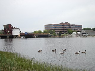
The Neponset River is a river in eastern Massachusetts in the United States. Its headwaters are at the Neponset Reservoir in Foxborough, near Gillette Stadium. From there, the Neponset meanders generally northeast for about 29 miles (47 km) to its mouth at Dorchester Bay between Quincy and the Dorchester section of Boston, near the painted gas tank.

<span class="mw-page-title-main">Bunker Hill Monument</span> War monument in Boston, Massachusetts, US

The Bunker Hill Monument is a monument erected at the site of the Battle of Bunker Hill in Boston, Massachusetts, which was among the first major battles between the Red Coats and Patriots in the American Revolutionary War. The 221-foot granite obelisk was erected between 1825 and 1843 in Charlestown, Massachusetts, with granite from nearby Quincy conveyed to the site via the purpose-built Granite Railway, followed by a trip by barge. There are 294 steps to the top.

<span class="mw-page-title-main">Gridley Bryant</span> American engineer

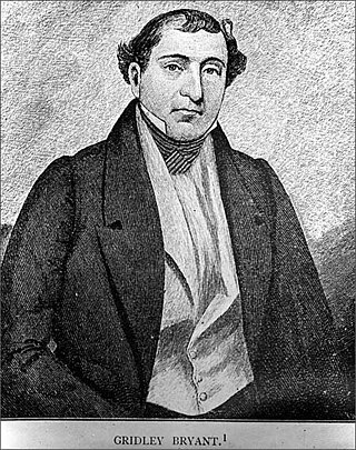
Gridley Bryant was an American construction engineer who ended up building the first commercial railroad in the United States and inventing most of the basic technologies involved in it. His son, Gridley James Fox Bryant, was a famous 19th-century architect and builder.

<span class="mw-page-title-main">Mount Lowe Railway</span> United States historic place

The Mount Lowe Railway was the third in a series of scenic mountain railroads in the United States created as a tourist attraction on Echo Mountain and Mount Lowe, north of Los Angeles, California. The railway, originally incorporated by Thaddeus S. C. Lowe as the Pasadena and Mt. Wilson Railroad Co., existed from 1893 until its official abandonment in 1938, and was the only scenic mountain, electric traction railroad ever built in the United States. Lowe's partner and engineer was David J. Macpherson, a civil engineer graduate of Cornell University. The Mount Lowe Railway was a fulfillment of 19th century Pasadenans' desire to have a scenic mountain railroad to the crest of the San Gabriel Mountains.

<span class="mw-page-title-main">Oldest railroads in North America</span> List of earliest railroads in North America

This is a list of the earliest railroads in North America, including various railroad-like precursors to the general modern form of a company or government agency operating locomotive-drawn trains on metal tracks.

<span class="mw-page-title-main">Solomon Willard</span> American architect

Solomon Willard was a carver and builder in Massachusetts who is remembered primarily for designing and overseeing the Bunker Hill Monument, the first monumental obelisk erected in the United States.

<span class="mw-page-title-main">Peak Forest Tramway</span>

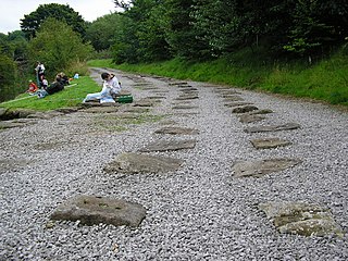
The Peak Forest Tramway was an early horse- and gravity-powered industrial railway system in Derbyshire, England. Opened for trade on 31 August 1796, it remained in operation until the 1920s. Much of the route and the structures associated with the line remain. The western section of the line is now the route of the Peak Forest Tramway Trail.

<span class="mw-page-title-main">Canton Viaduct</span> Railroad viaduct in Massachusetts, U.S.

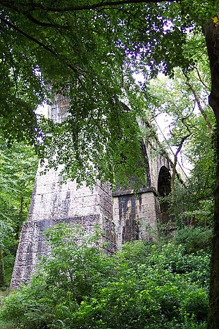
Canton Viaduct is a blind arcade cavity wall in Canton, Massachusetts, built in 1834–35 for the Boston and Providence Railroad.

<span class="mw-page-title-main">Delaware and Hudson Gravity Railroad</span> American gravity railroad incorporated and chartered in 1826

A predecessor to the Class I Delaware and Hudson Railway, the 1820s-built Delaware and Hudson Canal Company Gravity Railroad('D&H Gravity Railroad') was a historic gravity railroad incorporated and chartered in 1826 with land grant rights in the US state of Pennsylvania as a humble subsidiary of the Delaware and Hudson Canal and it proved to contain the first trackage of the later organized Delaware and Hudson Railroad. It began as the second long U.S. gravity railroad built initially to haul coal to canal boats, was the second railway chartered in the United States after the Mohawk and Hudson Rail Road before even, the Baltimore and Ohio. As a long gravity railway, only the Summit Hill and Mauch Chunk Railroad pre-dated its beginning of operations.

The Leiper Railroad was a 'family business–built' horse drawn railroad of 0.75 miles (1.21 km), constructed in 1810 after the quarry owner, Thomas Leiper, failed to obtain a charter with legal rights-of-way to instead build his desired canal along Crum Creek. The quarry man's 'make-do' railroad was the continent's first chartered railway, first operational non-temporary railway, first well-documented railroad, and first constructed railroad also meant to be permanent.

The credit of constructing the first permanent tramway in America may therefore be rightly given to Thomas Leiper. He was the owner of a fine quarry not far from Philadelphia, and was much concerned to find an easy mode of carrying stone to tide-water. That a railway would accomplish this end he seem to have had no doubt. To test the matter, and at the same time afford a public exhibition of the merits of tramways, he built a temporary track in the yard of the Bull's Head Tavern in Philadelphia. The tramway was some sixty feet long, had a grade of one inch and a half to the yard, and up it, to the amazement of the spectators, one horse used to draw a four-wheeled wagon loaded with a weight of ten thousand pounds. This was the summer of 1809. Before autumn laborers were at work building a railway from the quarry to the nearest landing, a distance of three quarters of a mile. In the spring of 1810 the road began to be used and continued in using during eighteen years.
by John Bach McMaster, page 494, A History of the People of the United States, from the Revolution to the Civil War

<span class="mw-page-title-main">Treffry Viaduct</span> Bridge in Luxulyan Valley, Cornwall

The Treffry Viaduct is a historic dual-purpose railway viaduct and aqueduct located close to the village of Luxulyan, Cornwall in the United Kingdom. The viaduct crosses the Luxulyan Valley, and with it forms an integral part of the Cornwall and West Devon Mining Landscape, a World Heritage Site. It is scheduled under the Ancient Monuments and Archaeological Areas Act 1979 and due to its poor condition is on Historic England's, Heritage at Risk Register.

<span class="mw-page-title-main">Treffry Tramways</span>

The Treffry Tramways were a group of mineral tramways in Cornwall in the United Kingdom, constructed by Joseph Treffry (1782–1850), a local land owner and entrepreneur. They were constructed to give transport facilities to several mines and pits producing non-ferrous metal, granite and china clay in the area between the Luxulyan Valley and Newquay, and were horse-operated, with the use of water and steam power on inclines, and at first operated in conjunction with the Par Canal and Par Docks, also constructed by Treffry. One of the routes crossed the Luxulyan Valley on a large viaduct, the largest in Cornwall when it was built.

<span class="mw-page-title-main">Quincy Quarries Reservation</span> Former quarry in Quincy, Massachusetts

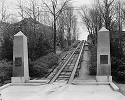
The Quincy Quarries is a 22-acre (8.9 ha) public recreation area in Quincy, Massachusetts, commemorating the site of the Granite Railway—often credited as being the first railroad in the United States. The former quarries produced granite for over a century, leaving problematic excavations that ultimately were taken over and filled in to protect public safety. The reservation is owned and operated by the Massachusetts Department of Conservation and Recreation.

<span class="mw-page-title-main">Paul's Bridge</span> Bridge in Massachusetts, USA

Paul's Bridge is a stone bridge carrying the Neponset Valley Parkway over the Neponset River between Milton and southern Boston, Massachusetts. It was built in 1849 by Thomas Hollis, Jr., of Milton, but was later reconstructed using the original materials. It replaced the earlier Hubbard's Bridge, and a subsequent Paul's Bridge. Its current span is approximately 88 feet (27 m). The name "Paul" can be attributed to Samuel Paul, the owner of the adjacent land on the Readville side, which was part of Dedham at the time of the bridge's construction.

<span class="mw-page-title-main">Furnace Brook Parkway</span> Historic parkway in Quincy, Massachusetts

Furnace Brook Parkway is a historic parkway in Quincy, Massachusetts. Part of the Metropolitan Park System of Greater Boston, it serves as a connector between the Blue Hills Reservation and Quincy Shore Reservation at Quincy Bay. First conceived in the late nineteenth century, the state parkway is owned and maintained by the Massachusetts Department of Conservation and Recreation (DCR) and travels through land formerly owned by the families of John Adams and John Quincy Adams, passing several historic sites. It ends in the Merrymount neighborhood, where Quincy was first settled by Europeans in 1625 by Captain Richard Wollaston. The road was started in 1904, completed in 1916 and added to the National Register of Historic Places (NRHP) in 2004.

<span class="mw-page-title-main">Captain Nathan Hale Monument</span> United States historic place

The Captain Nathan Hale Monument is a 45-foot (14 m) obelisk in Coventry, Connecticut, built in 1846 in honor of Nathan Hale, the Revolutionary War hero, who was born in Coventry. It was one of the first war memorials to be built in the United States, and is a significant work of both architect Henry Austin and builder Solomon Willard. Now owned and maintained by the state, it was listed on the National Register of Historic Places in 2002.

<span class="mw-page-title-main">Dorchester and Milton Branch Railroad</span> Former rail line in Massachusetts, US

The Dorchester and Milton Branch Railroad was a railroad in Massachusetts. It ran between Neponset Village in Dorchester, Massachusetts, through the town of Milton to the village of Mattapan. It was opened in 1847 and became part of the Old Colony Railroad system in 1848. The western portion was converted to a streetcar line in 1929, while the eastern portion remained in use for freight until the 1980s.

<span class="mw-page-title-main">Hardwick and Woodbury Railroad</span> American railway line

The Hardwick and Woodbury Railroad was a short-line railroad serving the towns of Hardwick and Woodbury, Vermont. Built to serve the local granite industry by bringing rough stone from the quarries to the cutting-houses, the railroad was about 7 miles (11 km) long, plus leased track, extended to about 11 miles (18 km) at its greatest extent. It connected with only one other railroad, the St. Johnsbury & Lake Champlain, in Hardwick.

References

  1. 1 2 3 "National Register Information System". National Register of Historic Places . National Park Service. March 13, 2009.
  2. 1 2 Wood, Frederick J. (1919). The Turnpikes of New England. Boston: Marshall Jones Company. p. 208.
  3. "Friends of the Blue Hills Journal of Fanny Kemble". Archived from the original on July 11, 2007. Retrieved March 30, 2007.
  4. "W. Quincy Branch of Old Colony to Cease Sept 30". Boston Globe. September 7, 1940. p. 14 via Newspapers.com. Open Access logo PLoS transparent.svg
  5. Karr, Ronald Dale (2017). The Rail Lines of Southern New England (2 ed.). Branch Line Press. pp. 376–381. ISBN   9780942147124.
  6. Scholes, Robert E. (1968). "The Successor Railroads". The Granite Railway and its Associated Enterprises. Thomas Crane Library. Archived from the original on September 12, 2015. Retrieved October 11, 2015.
  7. Lives and works of civil and military engineers of America, Charles B. Stuart, D. Van Nostrand, 1871, pp. 121–124.
  8. "NRHP nomination for Quincy Granite Railway". Commonwealth of Massachusetts. Retrieved October 7, 2016.
  9. "The Granite Railway Historical Marker". The Historical Marker Database. Retrieved March 6, 2021.
  10. White, Victoria (August 21, 1988). "Debate on over risks in quarries". New York Times. Retrieved December 17, 2014.
  11. Preer, Robert (October 18, 2001). "Into quarry's depths no more". The Boston Globe.