Description
Cloaked in woods and pastures, Mount Cornacchia is located on the border between the municipalities of Biccari and Faeto. Along the northern slopes of the hill, the sources of the Vulgano [ it ] stream gush out with some hydrocarbon deposits as well as Lake Pescara, the only natural mountain lake in Apulia (located at 902 m, extending over 3 hectares and 6 m deep). [3] The southern side opens into a wide valley, the Valmaggiore [ it ], crossed by the Celone [ it ] stream and populated by the only Franco-Provençal minority in Apulia.
From the top of the mountain, reachable via a carriage road, there is a vast landscape including the Gargano, the Tavoliere, the Irpinia, the Matese and the Maiella. [4] A few meters from the summit, there is a refuge built in 1980 and then reactivated in 2012 after a fire devastated it in 2007. [5] By virtue of its considerable ecological importance, the entire massif of Mount Cornacchia, together with the contiguous forest of Faeto, is a site of community interest. [6]

Apulia, also known by its Italian name Puglia, is a region of Italy, located in the southern peninsular section of the country, bordering the Adriatic Sea to the east, the Strait of Otranto and Ionian Sea to the southeast and the Gulf of Taranto to the south. The region comprises 19,345 square kilometers (7,469 sq mi), and its population is about four million people. It is bordered by the other Italian regions of Molise to the north, Campania to the west, and Basilicata to the southwest. Its chief town is Bari.

Abruzzo, historically known as Abruzzi, is a region of Southern Italy with an area of 10,763 square km and a population of 1.3 million. It is divided into four provinces: L'Aquila, Teramo, Pescara, and Chieti. Its western border lies 80 km (50 mi) east of Rome. Abruzzo borders the region of Marche to the north, Lazio to the west and north-west, Molise to the south and the Adriatic Sea to the east. Geographically, Abruzzo is divided into a mountainous area in the west, which includes the highest massifs of the Apennines, such as the Gran Sasso d'Italia and the Maiella, and a coastal area in the east with beaches on the Adriatic Sea.

The province of Foggia is a province in the Apulia (Puglia) region of southern Italy.

Avezzano is a city and comune with a population of 40,661 inhabitants, situated in the Abruzzo region, province of L'Aquila, Italy. It is the second most populous municipality in the province and the sixth in the region. Avezzano was documented as an existing urban center in the ninth century. The city was destroyed by the earthquake of 1915. It was rebuilt after the 1944 Allied bombing. The city was decorated with the silver medal for civil merit, an award granted by the Italian Republic.

Castel del Monte is a 13th-century citadel and castle situated on a hill in Andria in the Apulia region of southeast Italy. It was built during the 1240s by King Frederick II, who had inherited the lands from his mother Constance of Sicily. In the 18th century, the castle's interior marbles and remaining furnishings were removed. It has neither a moat nor a drawbridge and some considered it never to have been intended as a defensive fortress. However, archaeological work has suggested that it originally had a curtain wall.
Gioia del Colle is a town and comune of the Metropolitan City of Bari, Apulia, southern Italy. The town is located on the Murge plateau at 360 metres (1,180 ft) above sea level, between the Adriatic and Ionian seas.

Gravina in Puglia is a town and comune of the Metropolitan City of Bari, Apulia, southern Italy.

Greci is an Arbëreshë town and comune in the province of Avellino, Campania, Italy, located about 100 km northeast of Naples and about 50 km southwest of Foggia. It is a mountain agricultural village lying astride the Apennines and represents the only existing linguistic minority in Campania; Arbereshe people have settled in Greci since the 15th century.

Celle di San Vito is a town and comune in the province of Foggia of the Apulia region in southern Italy.

Panni is a village and comune in the province of Foggia in the Apulia region of southeast Italy.
The Monti Marsicani are the sixth-highest group of Apennines located in the Abruzzo region, mostly in the Province of L’Aquila and partly in the Province of Frosinone and Province of Isernia. The highest peak is Monte Greco (2285m). They are limited in north by the Fucino plateau and Peligna Valley, on the east by the River Gizio and Altopiano delle Cinque Miglia, on the south by the Valley Sangro and Volturno, on the east by valley Liri and Melfa.
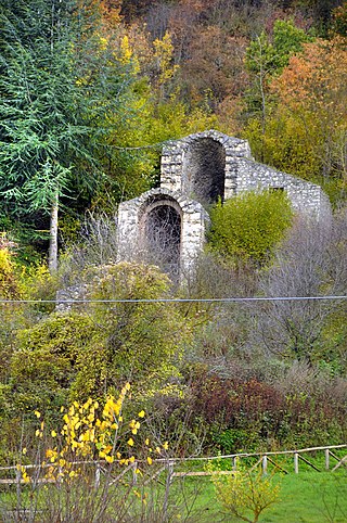
Faetar, fully known as Faetar-Cigliàje is a variety of the Franco-Provençal language that is spoken in two small communities in Foggia, Italy: Faeto and Celle di San Vito, as well as émigré communities in Ontario, Canada.
Banca Popolare di Puglia e Basilicata S.C.p.A. is an Italian cooperative bank based in Altamura, in the Province of Bari, Apulia.
Banca Popolare Pugliese S.C.p.A. (BPP) is an Italian cooperative bank based in Parabita and Matino, in the Province of Lecce, Apulia region.
Banca Apulia S.p.A. marketed as BancApulia is an Italian bank incorporated in San Severo, in the Province of Foggia, Apulia region. The main office of the bank was located in Bari, in the centre of Apulia region instead. The bank was takeover by Intesa Sanpaolo, after the previous owner was under administration and then being liquidated.
The Tunnels of Claudius consist principally of a 6 km-long tunnel together with several monumental service tunnels which Roman Emperor Claudius had built by 52 AD to partially drain the Fucine Lake in Abruzzo, protecting riparian villages from floods and creating agricultural land. It was a massive engineering project involving 30000 workmen and slaves who completed it in just 11 years, and considered among the grandest in antiquity. It was the longest tunnel ever built until the inauguration of the Fréjus Rail Tunnel in 1871.

Apulian cuisine consists of the cooking traditions and practices of the region of Apulia in Italy. Starting from the Middle Ages the permanent residence of the nobility in the region gradually declined, which caused the disappearance of their noble cuisine over time. As the common people suffered from poverty, their culinary tradition adapted to use cheap and simple foods. Bread, vegetables and pasta have the leading role in the cuisine. Fruits, fish and wine are consumed frequently as well, but meat plays a minor role. The food of Apulia is known as a prime example of cucina povera or 'cuisine of the poor', characterizing its simplicity rather than its quality. Moreover, the simple dishes allow the quality of their local and seasonal ingredients to take center stage.

The Cinque Vette Park is a natural park, established by the Region of Lombardy on 19 June 2017. The park is located in the north-eastern part of the Province of Varese, in the Italian region of Lombardy. It takes the name from the main geographic features located in the park, the five mountain peaks. The project was launched with the aim of the three local councils of to preserve a green area and make it available for touristic-sportive-cultural initiatives above 500 meters of altitude. The primary goal of the park is to encourage the discovery of the natural features of the north-eastern part of Varese, which offers panoramic view points and preserves historical aspects such as: the remains of the Cadorna Line; the ruins of the Castle of Cuasso al Monte; the Artistic village of Boarezzo; the Saint Gemolo Abbey; the Alpine Village of Mount Piambello; and, the Hospital of Cuasso Al Monte.
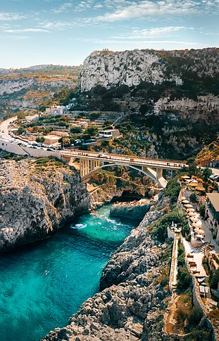
Ciolo is a narrow coastal inlet and a site of historical and environmental interest, which is located in Apulia, Italy. The location is also known as a geological site and for the presence of numerous sea caves, the largest one being the Grotta del Ciolo. Since October 2006 the Ciolo's area has become part of the Regional Park "Costa Otranto - Santa Maria di Leuca e Bosco di Tricase", created by the Apulia region to protect the eastern coast of Salento, specifically the architectural assets as well as important animal and plant species.

The culture of Apulia, the region that constitutes the extreme southeast of the Italian peninsula, has had, since ancient times, mixed influences from the West and the East, due to its strategic position near the transition zone between these two cultural regions. Its location, on the west coast of the Adriatic and Ionian seas, the natural southern border between Western Europe and the Balkans and Greece, made it a bridge to the East since antiquity, and in the Middle Ages, it was a cultural frontier between the Roman-Germanic West and the Greek-Byzantine East.

