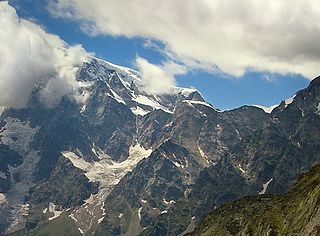
The Dufourspitze is the highest peak of Monte Rosa, an ice-covered mountain massif in the Alps. Dufourspitze is the highest mountain peak of both Switzerland and the Pennine Alps and is also the second-highest mountain of the Alps and Western Europe, after Mont Blanc. It is located between Switzerland and Italy.

The Monte Rosa Tour is a circular hiking trail through the Swiss & Italian Alps around Monte Rosa (4634m). The tour also encircles the Dom in the Mischabel range.

Monte Rosa is a mountain massif in the eastern part of the Pennine Alps. It is between Italy's and Switzerland's (Valais). Monte Rosa is the second highest mountain in the Alps and western Europe, after Mont Blanc.

The Alps cover a large area. This article describes the delimitation of the Alps as a whole and of subdivisions of the range, follows the course of the main chain of the Alps and discusses the lakes and glaciers found in the region.

Macugnaga is a mountain village and a comune at 1,327 metres (4,354 ft) elevation, in the province of Verbano-Cusio-Ossola, in the north of the Piedmont region of Italy.
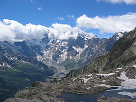
The Jägerhorn is a mountain of the Pennine Alps, located on the border between Switzerland and Italy. It lies just north of Monte Rosa, at a height of 3,970 metres above sea level, and overlooks the village of Macugnaga on its east side, 2,600 metres below. On its west side it overlooks the Gorner Glacier.

Castor is a mountain in the Pennine Alps on the border between Valais, Switzerland and the Aosta Valley in Italy. It is the higher of a pair of twin peaks, the other being Pollux, named after the Gemini twins of Roman mythology. Castor's peak is at an elevation of 4,223 m (13,855 ft), and it lies between Breithorn and the Monte Rosa. It is separated from Pollux by a pass at 3,847 m (12,621 ft), named Passo di Verra in Italian and Zwillingsjoch in German.

Pollux is a mountain in the Pennine Alps on the border between Valais, Switzerland and the Aosta Valley in Italy. It is the lower of a pair of twin peaks, the other being Castor, named after the Gemini twins of Roman mythology. Pollux' peak is at an elevation of 4,092 m (13,425 ft). It is separated from Castor by a pass at 3,847 m (12,621 ft), named Passo di Verra in Italian, Col de Verra in French and Zwillingsjoch in German.

The Grenzgipfel is a peak of Monte Rosa Massif, located on the border between Italy and Switzerland.
The Cima di Jazzi is a mountain of the Pennine Alps, located on the Swiss-Italian border, just north of Monte Rosa. It overlooks Macugnaga on its east (Italian) side. The west (Swiss) side is entirely covered by glaciers.

Monte Moro is a mountain of the Pennine Alps, located on the Swiss-Italian border. It lies west of the Monte Moro Pass.
The Latelhorn is a mountain of the Pennine Alps, located on the border between Switzerland and Italy. It lies between the valleys of Saas (Valais) and Antrona (Piedmont), just north of the Antrona Pass.

The Portjengrat is a mountain of the Pennine Alps, located on the border between Switzerland and Italy. It lies south of the Weissmies and the Zwischbergen Pass, where the international border diverges away from the main Alpine watershed. The summit of the Portjengrat has an elevation of 3,654 metres above sea level and is the tripoint between the valleys of Saas, Divedro and Antrona. It is the culminating point of the Antrona valley.

Cima di Castello is a mountain of the Bregaglia Range, located on the border between Italy and Switzerland. With a height of 3,379 metres (11,086 ft) above sea level, it is the second highest mountain in the Bregaglia Range. Its summit lies between the valleys of the Albigna and Forno Glacier and the valley of Val Mello.
Monte Sissone is a mountain in the Bregaglia Range of the Alps, located on the border between Italy and Switzerland. Its summit is the tripoint between the Val Bregaglia, Val Masino and Val Malenco
Piz la Stretta is a mountain of the Livigno Alps, located on the border between Italy and Switzerland. Its 3,104-metre (10,184 ft) high summit overlooks the pass of La Stretta
Piz Tea Fondada is a mountain of the Ortler Alps, located on the border between Italy and Switzerland. On its southern Italian side it overlooks the Lago di Cancano. On its northern Swiss side it overlooks the Val da Tea Fondada, part of the Val Mora.

Monte Rogoria is a mountain of the Lugano Prealps, located on the border between Switzerland and Italy, north of Astano, at the foot of the Monte Lema. The summit and the majority of the mountain are in the Swiss canton of Ticino, whilst a part of the north-western flank lies in the Italian region of Lombardy. It has an elevation of 1,184 metres above sea level. The view from the summit of the mountain encompasses the Lake Maggiore, the Borromean Islands and the Monte Rosa massif. There is no official hiking trail leading to the summit itself, but there are trails to the mountain pass Forcola respectively Passo di Monte Faëta at an altitude of 1,117 metres located close to the summit plateau. Starting points are: Astano, Miglieglia and Dumenza.

The Stelvio Pass is a mountain pass in northern Italy bordering Switzerland at an elevation of 2,757 m (9,045 ft) above sea level. It is the highest paved mountain pass in the Eastern Alps, and the second highest in the Alps, 7 m (23 ft) below France's Col de l'Iseran.
The Muretto Pass is a high mountain pass in the Alps on the border between Switzerland and Italy. It connects Maloja in the Swiss canton of Graubünden with Chiesa in Valmalenco in the Italian region of Lombardy. The pass lies between Monte del Forno and Piz Fedoz.