Montecreto

Last updated
Montecreto
Comune
Comune di Montecreto
Montecreto-Stemma.png
Coat of arms
Italy provincial location map 2015.svg
Red pog.svg
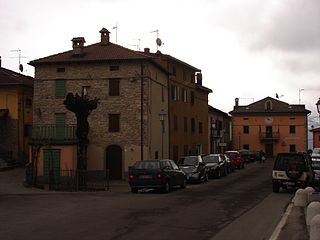
Montecreto
Location of Montecreto in Italy
Coordinates: 44°15′N10°43′E / 44.250°N 10.717°E / 44.250; 10.717
Country Italy
Region Emilia-Romagna
Province Modena (MO)
Frazioni Acquaria, Magrignana, Strettara, Rovinella
Government
  Mayor Leandro Bonucchi
Area
  Total 31.2 km2 (12.0 sq mi)
Elevation 864 m (2,835 ft)
Population (31 July 2015 [1] )
  Total 946
  Density 30/km2 (79/sq mi)
Demonym(s) Montecretesi
Time zone CET (UTC+1)
  Summer (DST) CEST (UTC+2)
Postal code41025
Dialing code 0536
Patron saint John the Baptist
Saint day 24th June
Website http://www.comune.montecreto.mo.it/

Montecreto (Frignanese: Muntcrêt) is a comune (municipality) in the Province of Modena in the Italian region Emilia-Romagna, located about 60 kilometres (37 mi) southwest of Bologna and about 50 kilometres (31 mi) southwest of Modena.

<i>Comune</i> third-level administrative divisions of the Italian Republic

The comune is a basic administrative division in Italy, roughly equivalent to a township or municipality.

Province of Modena Province of Italy

The Province of Modena is a province in the Emilia-Romagna region of Italy. Its capital is the city of Modena.

Italy republic in Southern Europe

Italy, officially the Italian Republic, is a country in Southern Europe. Located in the middle of the Mediterranean Sea, Italy shares open land borders with France, Switzerland, Austria, Slovenia and the enclaved microstates San Marino and Vatican City, as well as a maritime border with Croatia. Italy covers an area of 301,340 km2 (116,350 sq mi) and has a largely temperate seasonal and Mediterranean climate. With around 61 million inhabitants, it is the fourth-most populous EU member state and the most populous country in Southern Europe.

Montecreto borders the following municipalities: Lama Mocogno, Pavullo nel Frignano, Riolunato, Sestola.

Lama Mocogno Comune in Emilia-Romagna, Italy

Lama Mocogno is a comune (municipality) in the Province of Modena in the Italian region Emilia-Romagna, located about 50 kilometres (31 mi) southwest of Bologna and about 40 kilometres (25 mi) southwest of Modena. The Monte Cimone is located nearby.

Pavullo nel Frignano Comune in Emilia-Romagna, Italy

Pavullo nel Frignano is a town and comune in the province of Modena, Emilia-Romagna, Italy, in the Modenese Apeninnes. It is home to the medieval Castle of Montecuccolo, birthplace of the 17th century condottiero Raimondo Montecuccoli, and of the pieve of San Giovanni Battista di Renno. The town was extensively damaged during World War II due to its proximity to the Gothic Line.

Riolunato Comune in Emilia-Romagna, Italy

Riolunato is a comune (municipality) in the Province of Modena in the Italian region Emilia-Romagna, located about 60 kilometres (37 mi) southwest of Bologna and about 50 kilometres (31 mi) southwest of Modena. It is overlooked from the south by the Monte Cimone. Its fraction Le Polle, about 1,300 metres (4,300 ft) high, is one of the most important stations in the Monte Cimone Ski resort.

Related Research Articles

Bastiglia Comune in Emilia-Romagna, Italy

Bastiglia is a comune (municipality) in the Province of Modena in the Italian region Emilia-Romagna, located about 40 kilometres (25 mi) northwest of Bologna and about 11 kilometres (7 mi) northeast of Modena.

Bomporto Comune in Emilia-Romagna, Italy

Bomporto is a comune (municipality) in the Province of Modena in the Italian region Emilia-Romagna, located about 35 kilometres (22 mi) northwest of Bologna and about 12 kilometres (7.5 mi) northeast of Modena.

Campogalliano Comune in Emilia-Romagna, Italy

Campogalliano is a comune (municipality) in the Province of Modena in the Italian region Emilia-Romagna, located about 45 kilometres (28 mi) northwest of Bologna and about 8 kilometres (5 mi) northwest of Modena.

Cavezzo Comune in Emilia-Romagna, Italy

Cavezzo is a comune (municipality) in the Province of Modena in the Italian region Emilia-Romagna, located about 45 kilometres (28 mi) northwest of Bologna and about 20 kilometres (12 mi) northeast of Modena.

Fanano Comune in Emilia-Romagna, Italy

Fanano is a comune (municipality) in the Province of Modena in the Italian region Emilia-Romagna, located about 50 kilometres (31 mi) southwest of Bologna and about 50 kilometres (31 mi) south of Modena.

Fiumalbo Comune in Emilia-Romagna, Italy

Fiumalbo is a comune (municipality) in the Province of Modena in the Italian region Emilia-Romagna, located about 70 kilometres (43 mi) southwest of Bologna and about 60 kilometres (37 mi) southwest of Modena.

Frassinoro Comune in Emilia-Romagna, Italy

Frassinoro is a comune (municipality) in the Province of Modena in the Italian region Emilia-Romagna, located about 70 kilometres (43 mi) southwest of Bologna and about 50 kilometres (31 mi) southwest of Modena.

Guiglia Comune in Emilia-Romagna, Italy

Guiglia is a comune (municipality) in the Province of Modena in the Italian region Emilia-Romagna, located about 30 kilometres (19 mi) southwest of Bologna and about 25 kilometres (16 mi) south of Modena.

Montefiorino Comune in Emilia-Romagna, Italy

Montefiorino is a comune (municipality) in the Province of Modena in the Italian region Emilia-Romagna, located about 60 kilometres (37 mi) southwest of Bologna and about 40 kilometres (25 mi) southwest of Modena.

Novi di Modena Comune in Emilia-Romagna, Italy

Novi di Modena is a comune (municipality) in the Province of Modena in the Italian region Emilia-Romagna, located about 60 kilometres (37 mi) northwest of Bologna and about 25 kilometres (16 mi) north of Modena in the Pianura Padana.

Palagano Comune in Emilia-Romagna, Italy

Palagano is a comune (municipality) in the Province of Modena in the Italian region Emilia-Romagna, located about 60 kilometres (37 mi) southwest of Bologna and about 45 kilometres (28 mi) southwest of Modena. As of 31 December 2004, it had a population of 2,455 and an area of 60.4 square kilometres (23.3 sq mi).

Polinago Comune in Emilia-Romagna, Italy

Polinago is a comune (municipality) in the Province of Modena in the Italian region Emilia-Romagna, located about 50 kilometres (31 mi) southwest of Bologna and about 40 kilometres (25 mi) southwest of Modena.

Prignano sulla Secchia Comune in Emilia-Romagna, Italy

Prignano sulla Secchia is a comune (municipality) in the Province of Modena in the Italian region Emilia-Romagna, located about 50 kilometres (31 mi) west of Bologna and about 30 kilometres (19 mi) southwest of Modena. It is in the Modenese Appennines, in the valley of the Secchia river.

San Possidonio Comune in Emilia-Romagna, Italy

San Possidonio is a comune (municipality) in the Province of Modena in the Italian region Emilia-Romagna, located about 50 kilometres (31 mi) northwest of Bologna and about 35 kilometres (22 mi) northeast of Modena.

Serramazzoni Comune in Emilia-Romagna, Italy

Serramazzoni is a comune (municipality) in the Province of Modena in the Italian region Emilia-Romagna, located about 45 kilometres (28 mi) west of Bologna and about 30 kilometres (19 mi) southwest of Modena.

Sestola Comune in Emilia-Romagna, Italy

Sestola is a comune (municipality) in the Province of Modena in the Italian region Emilia-Romagna, located about 60 kilometres (37 mi) southwest of Bologna and about 50 kilometres (31 mi) southwest of Modena. It is located near the Monte Cimone and other mountains of the northern Apennines separating Emilia and Tuscany.

Soliera Comune in Emilia-Romagna, Italy

Soliera is a comune (municipality) in the Province of Modena in the Italian region Emilia-Romagna, located about 40 kilometres (25 mi) northwest of Bologna and about 9 kilometres (6 mi) north of Modena.

Zocca Comune in Emilia-Romagna, Italy

Zocca is a comune (municipality) in the Province of Modena in the Italian region Emilia-Romagna, located about 45 kilometres (28 mi) southwest of Bologna and about 35 kilometres (22 mi) south of Modena.

References

  1. All demographics and other statistics: Italian statistical institute Istat.