Montefortino | |
---|---|
Comune | |
Comune di Montefortino | |
Coordinates: 42°57′N13°21′E / 42.950°N 13.350°E | |
Country | Italy |
Region | Marche |
Province | Fermo |
Government | |
• Mayor | Domenico Ciaffaroni |
Area | |
• Total | 78.5 km2 (30.3 sq mi) |
Elevation | 638 m (2,093 ft) |
Population (30 September 2015) [1] | |
• Total | 1,179 |
• Density | 15/km2 (39/sq mi) |
Demonym(s) | Montefortinesi o fortinesi |
Time zone | CET (UTC+1) |
• Summer (DST) | CEST (UTC+2) |
Postal code | 63047 |
Dialing code | 0736 |
Website | Official website |
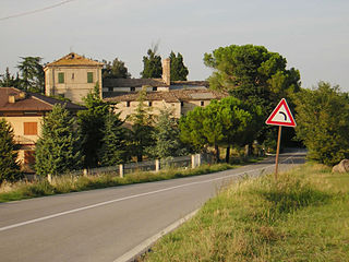
Montefortino is a comune (municipality) in the Province of Fermo in the Italian region Marche, located about 80 kilometres (50 mi) south of Ancona, about 35 kilometres (22 mi) northwest of Ascoli Piceno and about 45 kilometres (28 mi) west of Fermo.
The comune is a basic administrative division in Italy, roughly equivalent to a township or municipality.
The province of Fermo is a province in the Marche region of central Italy. It was established in 2004 and became operational in 2009. Its administrative centre and provincial capital is the city of Fermo. Other major cities include Porto Sant'Elpidio, Porto San Giorgio, Sant'Elpidio a Mare, and Montegranaro. As of 2017, the province has a population of 174,358 inhabitants and spans an area of 862.77 square kilometres (333.12 sq mi). It contains 40 comuni.
Italy, officially the Italian Republic, is a country in Southern Europe. Located in the middle of the Mediterranean Sea, Italy shares open land borders with France, Switzerland, Austria, Slovenia and the enclaved microstates San Marino and Vatican City, as well as a maritime border with Croatia. Italy covers an area of 301,340 km2 (116,350 sq mi) and has a largely temperate seasonal and Mediterranean climate. With around 61 million inhabitants, it is the fourth-most populous EU member state and the most populous country in Southern Europe.
Montefortino borders the following municipalities: Amandola, Bolognola, Castelsantangelo sul Nera, Comunanza, Montemonaco, Sarnano, Ussita, Visso.
Amandola is a comune (municipality) in the Province of Fermo in the Italian region Marche, located about 70 kilometres (43 mi) south of Ancona, about 25 kilometres (16 mi) northwest of Ascoli Piceno and about 35 kilometres (22 mi) west of Fermo. The city was founded in 1248 by the union of the castles of Agello Leone and Marrubbione, which formed a free municipality.
Bolognola is a comune (municipality) in the Province of Macerata in the Italian region Marche, located about 70 kilometres (43 mi) southwest of Ancona and about 40 kilometres (25 mi) southwest of Macerata.
Castelsantangelo sul Nera is a comune (municipality) in the Province of Macerata in the Italian region of Marche, located about 90 kilometres (56 mi) southwest of Ancona and about 50 kilometres (31 mi) southwest of Macerata. The source of the Nera River is located in the communal territory.
The city art collection is housed in the Pinacoteca Civica Fortunato Duranti.
The Pinacoteca Civica Fortunato Duranti is a museum in Montefortino, Italy.
San Fermo della Battaglia is a comune (municipality) in the Province of Como in the Italian region Lombardy, located about 40 kilometres (25 mi) north of Milan and about 3 kilometres (2 mi) southwest of Como. As of 31 December 2004, it had a population of 4,255 and an area of 3.1 square kilometres (1.2 sq mi).
Entratico is a comune (municipality) in the Province of Bergamo in the Italian region of Lombardy, located about 60 kilometres (37 mi) northeast of Milan and about 15 kilometres (9.3 mi) east of Bergamo. As of 31 December 2004, it had a population of 1,620 and an area of 4.1 km².
Foresto Sparso is a comune (municipality) in the Province of Bergamo in the Italian region of Lombardy, located about 60 kilometres (37 mi) northeast of Milan and about 20 kilometres (12 mi) east of Bergamo. As of 31 December 2004, it had a population of 2,983 and an area of 7.7 square kilometres (3.0 sq mi).
Grone is a comune (municipality) in the Province of Bergamo in the Italian region of Lombardy, located about 70 kilometres (43 mi) northeast of Milan and about 20 kilometres (12 mi) east of Bergamo. As of 31 December 2004, it had a population of 817 and an area of 7.8 square kilometres (3.0 sq mi).
Vigano San Martino is a comune (municipality) in the Province of Bergamo in the Italian region of Lombardy, located about 60 kilometres (37 mi) northeast of Milan and about 20 kilometres (12 mi) east of Bergamo.
Belmonte Piceno is a comune (municipality) in the Province of Fermo in the Italian region Marche, located about 60 kilometres (37 mi) south of Ancona and about 30 kilometres (19 mi) north of Ascoli Piceno.
Francavilla d'Ete is a comune (municipality) in the Province of Fermo in the Italian region Marche, located about 50 kilometres (31 mi) south of Ancona and about 35 kilometres (22 mi) north of Ascoli Piceno.
Lapedona is a comune (municipality) in the Province of Fermo in the Italian region Marche, located about 60 kilometres (37 mi) southeast of Ancona and about 35 kilometres (22 mi) northeast of Ascoli Piceno. As of 31 December 2004, it had a population of 1,157 and an area of 14.8 square kilometres (5.7 sq mi).
Magliano di Tenna is a comune (municipality) in the Province of Fermo in the Italian region Marche, located about 50 kilometres (31 mi) south of Ancona and about 30 kilometres (19 mi) north of Ascoli Piceno. As of 31 December 2004, it had a population of 1,312 and an area of 7.8 square kilometres (3.0 sq mi).
Monte Giberto is a comune (municipality) in the Province of Fermo in the Italian region Marche, located about 60 kilometres (37 mi) south of Ancona and about 30 kilometres (19 mi) north of Ascoli Piceno. As of 31 December 2004, it had a population of 865 and an area of 12.7 square kilometres (4.9 sq mi).
Monteleone di Fermo is a comune (municipality) in the Province of Fermo in the Italian region Marche, located about 70 kilometres (43 mi) south of Ancona, about 35 kilometres (22 mi) north of Ascoli Piceno and 25 kilometres (16 mi) of Fermo. As of 31 December 2004, it had a population of 449 and an area of 8.1 square kilometres (3.1 sq mi).
Montelparo is a comune (municipality) in the Province of Fermo in the Italian region Marche, located about 75 kilometres (47 mi) south of Ancona, about 30 kilometres (19 mi) north of Ascoli Piceno and 35 kilometres (22 mi) of Fermo. As of 31 December 2004, it had a population of 929 and an area of 21.6 square kilometres (8.3 sq mi).
Monte Rinaldo is a comune (municipality) in the Province of Fermo in the Italian region Marche, located about 75 kilometres (47 mi) south of Ancona, about 30 kilometres (19 mi) north of Ascoli Piceno and 25 kilometres (16 mi) west of Fermo.
Monte Urano is a comune (municipality) in the Province of Fermo in the Italian region Marche, located about 50 kilometres (31 mi) south of Ancona and about 7 kilometres (4 mi) north of Fermo.
Petritoli is a comune (municipality) in the Province of Fermo in the Italian region Marche, located about 90 kilometres (56 mi) south of Ancona and about 50 kilometres (31 mi) north of Ascoli Piceno.
Ponzano di Fermo is a comune (municipality) in the Province of Fermo in the Italian region Marche, located about 60 kilometres (37 mi) south of Ancona and about 30 kilometres (19 mi) north of Ascoli Piceno. As of 31 December 2004, it had a population of 1,623 and an area of 14.4 square kilometres (5.6 sq mi).
Servigliano is a comune (municipality) in the Province of Fermo in the Italian region Marche, located about 60 kilometres (37 mi) south of Ancona and about 25 kilometres (16 mi) north of Ascoli Piceno. As of 31 December 2004, it had a population of 2,349 and an area of 18.5 square kilometres (7.1 sq mi).
Smerillo is a comune (municipality) in the Province of Fermo in the Italian region Marche, located about 80 kilometres (50 mi) south of Ancona, about 35 kilometres (22 mi) northwest of Ascoli Piceno and about 35 kilometres (22 mi) west of Fermo, on a spur midway from the Monti Sibillini and the Adriatic Sea.
This Marche location article is a stub. You can help Wikipedia by expanding it. |