
The geography of Switzerland encompasses the geographical features of Switzerland, a mountainous and landlocked country located in Western and Central Europe. Switzerland's natural landscape is marked by its numerous lakes and mountains. It is surrounded by 5 countries: Austria and Liechtenstein to the east, France to the west, Italy to the south and Germany to the north. Switzerland has a maximum north–south length of 220 kilometres (140 mi) and an east–west length of about 350 kilometres (220 mi).

The Weissenstein is a mountain of the Jura, located north of Solothurn in the Swiss canton of Solothurn. The culminating point of the chain is distinguished by the name Röti. It is the easternmost summit above 1,300 metres in the Jura Mountains.

Scarba is an island, in Argyll and Bute, Scotland, just north of the much larger island of Jura. The island was owned by Richard Hill, 7th Baron Sandys, and has not been permanently inhabited since the 1960s. It is now covered in heather and used for grazing animals. Kilmory Lodge is used seasonally as a shooting lodge, the island having a flourishing herd of red deer.
The Lägern is a wooded mountain of the Jura Mountains, stretching from Baden to Dielsdorf, about 15 km north-west of Zurich. The culminating point is located 1 km west of Hochwacht within the canton of Zurich, the border with the canton of Aargau running on a slightly lower summit named Burghorn.
Chasseral Pass is a high mountain pass in the Jura Mountains, lying west of the Chasseral. The pass is located on the border between the Swiss cantons of Neuchâtel and Bern. It is traversed by a road connecting Saint-Imier and Nods, both located in the Bernese Jura. North-east of the pass is the Chasseral Ouest, the highest point of the canton of Neuchâtel.

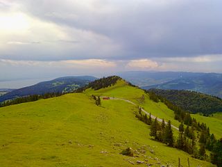
The Chasseral is a mountain of the Jura Mountains, overlooking Lake Biel in the Swiss canton of Bern. With an elevation of 1,606 metres above sea level, the Chasseral is the highest summit in the canton of Bern outside the Alps. It is also both the northernmost and easternmost mountain reaching over 1,500 metres in the Jura Mountains. West of the summit is located the Chasseral Ouest, where runs the border with the canton of Neuchâtel. The Chasseral Pass is located further on the west.

Beinn Bheigeir is a hill on the island of Islay in Scotland, UK. At 491 m, it is the highest of the seven 'Marilyn' hills on Islay, and the highest point on the island.
Le Reculet is the second-highest peak in the Jura Mountains, with an elevation of 1718 metres. It is located in the Ain department of France. It is a few kilometres south of the Crêt de la Neige on the territory of the town of Thoiry.

Mont Tendre is a mountain of the Jura, located between the valley of Joux and the basin of Lake Geneva in the canton of Vaud. With an elevation of 1,679 metres above sea level, it is the highest summit of the Swiss portion of the Jura Mountains and, therefore, the highest summit of Switzerland outside the Alps. It is also the most isolated mountain of the canton. It is found in the community of Montricher.

The Hasenmatt is a mountain of the Jura range, located north of Grenchen and Solothurn in the Swiss canton of Solothurn. Reaching a height of 1,445 metres above sea level, it is the highest summit in the canton of Solothurn. The Hasenmatt is also the easternmost summit above 1,400 metres of the Jura Mountains.

Mont Raimeux is a mountain of the Jura range, located on the border between the Swiss cantons of Jura and Berne. Reaching a height of 1,302 metres above sea level, it is the highest summit in the canton of Jura.

A Mittelgebirge is a type of relatively low mountain range or highland area typical of the geography of central Europe, especially central and southern Germany; it refers to something between rolling low hill country or Hügelland and a proper mountain range like the High Alps.
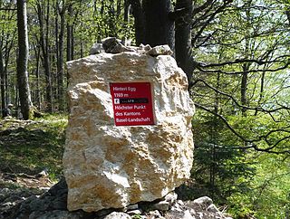
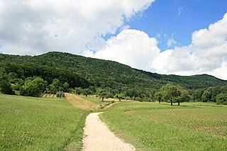
The Hinteri Egg is a mountain of the Jura, located south of Reigoldswil in the Swiss canton of Basel-Landschaft, close to the border with the canton of Solothurn.

The Hage is a mountain in the Randen range between the Jura and the Swabian Jura, located between Beggingen and Merishausen in the Swiss canton of Schaffhausen. Reaching a height of 912 metres above sea level, it is the highest point of the canton.

The Geissfluegrat is a minor summit east of the Geissflue, in the eastern Jura Mountains. It is located between the Swiss cantons of Aargau and Solothurn. With an elevation of 908 metres above sea level, the Geissfluegrat is the highest point in Aargau. It is also the easternmost summit above 900 metres in the Jura Mountains.
The Randen is a small mountain range located between the Jura and the Swabian Jura, north of the Rhine. Predominantly located in the Swiss canton of Schaffhausen, they culminate in the German state of Baden-Württemberg. The Randen, which belong to the Table Jura (Tafeljura), are situated north of Schaffhausen and south of Blumberg.

The Chasseral Ouest is a prominence west of the Chasseral, in the Jura Mountains. It is located on the border between the Swiss cantons of Neuchâtel and Bern. The Chasseral Ouest reaches an elevation of 1,552 metres above sea level and is the highest point of the canton of Neuchâtel.

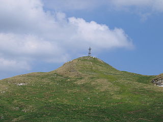
Mont Soleil is a mountain of the Jura Mountains, located north of Saint-Imier in the canton of Bern, Switzerland. The summit reaches to 1,291 metres (4,236 ft) and the area can be easily accessed by a funicular from Saint-Imier, reaching a height of 1,180 m (3,870 ft).
