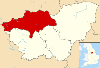
The Metropolitan Borough of Barnsley is a metropolitan borough of South Yorkshire, England; its main town is Barnsley.
Worsbrough is an area about two miles south of Barnsley in the metropolitan borough of Barnsley, South Yorkshire, England. Before 1974, Worsbrough had its own urban district council in the West Riding of the historic county of Yorkshire and it is still counted as a separate place from Barnsley by the 2011 Census, but it is often treated as part of Barnsley as the two settlements run into one another.

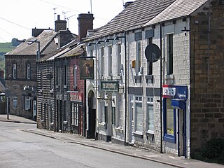
Dodworth is a village in the metropolitan borough of Barnsley in South Yorkshire, England. Historically part of the West Riding of Yorkshire, it has a population of 5,742, increasing to 5,900 at the 2011 Census.
The Hallam Line is a railway connecting Leeds and Sheffield via Castleford in the West Yorkshire Metro area of northern England. It is a slower route from Leeds to Sheffield than the Wakefield line. Services on this line are operated by Northern. Services from Leeds to Nottingham also use the line.
The Penistone Line is operated by Northern in the West Yorkshire Metro/ Travel South Yorkshire area of northern England. It connects Huddersfield and Sheffield via Penistone and Barnsley, serving many rural communities. Metrocards can be used for travel between Huddersfield and Denby Dale and intermediate stations.

Dodworth railway station serves the village of Dodworth, in the Metropolitan Borough of Barnsley, South Yorkshire, England. The station is 2 miles 71 chains (4.6 km) west of Barnsley on the Penistone Line between Huddersfield and Sheffield.
The Manchester–Sheffield–Wath electric railway was an electrification scheme on British railways. The route featured long ascents on both sides of the Pennines with the long Woodhead Tunnel at its central summit close to the Woodhead pass. This led to the route being called the Woodhead Line.

Oaks Viaduct spanned the Dearne Valley, in South Yorkshire. The viaduct was 1,087 feet (331 m) long and crossed Pontefract Road at Hoyle Mill, and spanned the Dearne Valley including the Dearne and Dove Canal and the Barnsley Coal Railway. It carried the Midland Railway's Cudworth-Barnsley branch. It opened to goods traffic in 1869 and to passenger traffic in 1870. On the Barnsley side the line gave access to Barnsley Main Colliery. The line also served Monk Bretton Colliery and a stub at the Cudworth end is still used to deliver sand to Refearn's Glass Works at Monk Bretton.
The South Yorkshire Railway was a railway company with lines in the south of the West Riding of Yorkshire, England.

The South Yorkshire Junction Railway was a railway which ran from Wrangbrook Junction on the main line of the Hull and Barnsley Railway to near Denaby Main Colliery Village, South Yorkshire. It was nominally an independent company sponsored by the Denaby and Cadeby Colliery Company but was worked by the Hull and Barnsley Railway.
The Hull and South Yorkshire Extension Railway was incorporated on 6 August 1897 and on 25 July 1898 was transferred to the Hull and Barnsley Railway. The bill was deposited by a group of local coal owners representing the Manvers Main Colliery Company, Hickleton Main Colliery, Wath Main Colliery, Wharncliffe Silkstone Colliery together with representatives of the Hull and Barnsley Railway.

The Barnsley Coal Railway was a short railway which, when fully opened, ran between Stairfoot Junction, on the Mexborough to Barnsley line of the South Yorkshire Railway (SYR) and a triangular junction at Nostell on the line of the West Riding and Grimsby Railway (WR&GR).
Kilnhurst Colliery, formerly known as either Thrybergh or Thrybergh Hall Colliery, was situated on the southern side of the village of Kilnhurst, near Rotherham, South Yorkshire, England.
The Elsecar Collieries were the coal mines sunk in and around Elsecar, a small village to the south of Barnsley in what is now South Yorkshire, but was traditionally in the West Riding of Yorkshire.

The River Dove is a river that extends through the Low Valley in Barnsley, England. It flows from Worsbrough Reservoir to its confluence with the River Dearne.
Elsecar goods station was a goods facility constructed near the village of Elsecar, near Barnsley, South Yorkshire, at the terminus of the South Yorkshire Railways branch line from Elsecar Junction on its Mexborough to Barnsley line. The total length of the line was 2 miles 1204 yards.
The Hull and Doncaster Branch is a secondary main railway line in England, connecting Kingston upon Hull to South Yorkshire and beyond via a branch from the Selby Line near Gilberdyke to a connection to the Barnsley to Barnetby Line at a junction near Thorne 8 miles northeast of Doncaster.
The Sheffield, Rotherham, Barnsley, Wakefield, Huddersfield and Goole Railway was an early British railway company. The company obtained an act in 1846 for 26 miles of railway, with a main section from Wakefield to Doncaster via Barnsley.

Barrow Colliery was a coal mine in Worsborough, South Yorkshire, England. It was first dug in 1873, with the first coal being brought to the surface in January 1876. It was the scene of a major incident in 1907 when seven miners died. After 109 years of coaling operations, the mine was closed in May 1985.
The Silkstone Waggonway was a narrow-gauge industrial wagonway serving the Barnsley Canal, in England, at Silkstone in South Yorkshire.
