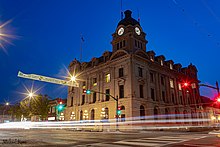
Moose Jaw is the fourth largest city in Saskatchewan, Canada. Lying on the Moose Jaw River in the south-central part of the province, it is situated on the Trans-Canada Highway, 77 km (48 mi) west of Regina. Residents of Moose Jaw are known as Moose Javians. The city is surrounded by the Rural Municipality of Moose Jaw No. 161.

Yorkville is a neighbourhood and former village in Toronto, Ontario, Canada. It is roughly bounded by Bloor Street to the south, Davenport Road to the north, Yonge Street to the east and Avenue Road to the west, and it is part of The Annex neighbourhood. Established as a separate community in 1830, it was annexed into Toronto in 1883. Yorkville comprises residential areas, office space, and retail shopping.

Moose Jaw North is a provincial electoral district for the Legislative Assembly of Saskatchewan, Canada. One of two provincial constituencies for the city of Moose Jaw, the riding contains the area of the city north of Caribou Street from 9th Avenue in the east to Thatcher Drive in the west.
Darling and Pearson was an architectural firm based in Toronto from 1895 through 1937. The firm was prolific and produced consistently fine work though the patronage of notable figures of the Canadian establishment, and is responsible for enhancing the architectural character and quality of the city, and indeed the rest of Canada, in the first quarter of the 20th century.

The history of Regina, Saskatchewan, the capital of the Canadian province of Saskatchewan. Prior to the province's establishment, Regina served as the territorial headquarters of the then-North-West Territories and district headquarters of the territorial district of Assiniboia.
Highway 1 is the Saskatchewan section of the Trans-Canada Highway mainland route. The total distance of the Trans-Canada Highway in Saskatchewan is 654 kilometres (406 mi). The highway traverses Saskatchewan from the western border with Alberta, from Highway 1, to the Manitoba border where it continues as PTH 1. The Trans-Canada Highway Act was passed on December 10, 1949. The Saskatchewan segment was completed August 21, 1957, and completely twinned on November 6, 2008. The speed limit along the majority of the route is 110 kilometres per hour (70 mph) with urban area thoroughfares slowing to a speed of 80–100 kilometres per hour (50–62 mph). Portions of the highway—the section through Swift Current, an 8-kilometre (5 mi) section east of Moose Jaw, and a 44-kilometre (27 mi) section between the West Regina Bypass and Balgonie—are controlled-access. Highway 1 serves as a major east–west transport route for commercial traffic. It is the main link between southern Saskatchewan's largest cities, and also serves as the province's main link to the neighbouring provinces of Alberta and Manitoba.
The Exchange District is a National Historic Site of Canada in the downtown area of Winnipeg, Manitoba, Canada. Just one block north of Portage and Main, the Exchange District comprises twenty city blocks and approximately 150 heritage buildings, and it is known for its intact early 20th century collection of warehouses, financial institutions, and early terracotta-clad skyscrapers.

The Canada Saskatchewan Production Studios are located in Regina, Saskatchewan at the corner of College Avenue and Broad Street. Built in 1913, the structure has served as a normal school, military training facility, and fine arts building for the University of Regina. It was internally gutted and reconstructed as a movie and television studio facility in 2002.

The Western Development Museum is a network of four museums in Saskatchewan, Canada preserving and recording the social and economic development of the province. The museum has branches in Moose Jaw, North Battleford, Saskatoon and Yorkton. Respectively, each branch focuses on a different theme: transportation, agriculture, economy, and people. The museum is affiliated with the Canadian Museums Association, the Canadian Heritage Information Network, and Virtual Museum of Canada.
Highway 2 is a provincial highway in the Canadian province of Saskatchewan. It is the longest highway in Saskatchewan at 809 km (503 mi). The highway has a few divided sections but is mostly undivided. However, only about 18 kilometres (11 mi) near Moose Jaw, 11 kilometres (7 mi) near Chamberlain, and 21 kilometres (13 mi) near Prince Albert are divided highway. Highway 2 is a major north-south route beginning at the Canada–US border at the Port of West Poplar River and Opheim, Montana customs checkpoints. Montana Highway 24 continues south. It passes through the major cities of Moose Jaw in the south and Prince Albert in the north. Highway 2 overlaps Highway 11 between the towns of Chamberlain and Findlater. This 11 kilometres (7 mi) section of road is a wrong-way concurrency. The highway ends at La Ronge, where it becomes Highway 102.

Culture of Saskatchewan views the patterns of human activity in the central prairie province of Canada examining the way people live in the geography, climate, and social context of Saskatchewan.
Mossbank is a town in the Canadian province of Saskatchewan. The town is south of Old Wives Lake and 68 km south of Moose Jaw.

Altario is a hamlet in east-central Alberta, Canada within Special Area No. 4. It is located on Highway 899 just north of Highway 12, approximately 12 kilometres (7.5 mi) east of Kirriemuir and 14 kilometres (8.7 mi) west of Compeer.
Storey and Van Egmond was an architectural partnership in Regina, Saskatchewan, Canada, that functioned from 1907 to 1924. Initially, the principals were Edgar M. Storey (1863-1913) and William Gysbert Van Egmond (1883-1949).

The Moose Jaw station is a former railway station in Moose Jaw, Saskatchewan, Canada. It was designed by John Schoefield, and built by the Canadian National Railway in 1919. The station, consisting of a two-storey central block with single-storey wings to the north and south, is constructed primarily of Claybank brick and Tyndall stone. The building was designated a historic railway station in 1992, and a municipal heritage property by the City of Moose Jaw on 8 April 2002. Its exterior has been restored and its interior extensively renovated by its current occupant, Sahara Spa, which operates a destination day spa in the building.

The Land Titles Building is located at 76 Fairford Street West in Moose Jaw, Saskatchewan, Canada. The architectural firm of Storey and Van Egmond designed the building. The building is a designated Heritage Property.

William Colston Albrant was an American architect practicing in Fargo, North Dakota.

Moose Jaw River is a river in the Canadian province of Saskatchewan. It is located in the southern part of the province in a region called the Prairie Pothole Region of North America, which extends throughout three Canadian provinces and five U.S. states. It is also within Palliser's Triangle and the Great Plains ecoregion.

Avonlea Creek is a river in the southern part of the Canadian province of Saskatchewan. It is in a region called the Prairie Pothole Region of North America, which extends throughout three Canadian provinces and five U.S. states. It is also within Palliser's Triangle and the Great Plains ecoregion. Avonlea Creek is a main tributary of the Moose Jaw River, which is part of the Upper Qu'Appelle Watershed and the Hudson Bay drainage basin.