
Belmopan is the capital city of Belize. Its population in 2010 was 16,451. In addition to being the smallest capital city in the continental Americas by population, Belmopan is the third-largest settlement in Belize, behind Belize City and San Ignacio. Founded as a planned community in 1970, Belmopan is one of the newest national capital cities in the world. Since 2000, Belmopan has been one of two settlements in Belize to hold official city status, along with Belize City.

Demographics of the population of Belize include population density, ethnicity, education level, health of the populace, economic status, religious affiliations and other aspects.

Corozal Town is a town in Belize, capital of Corozal District. Corozal Town is located about 84 miles north of Belize City, and 9 miles from the border with Mexico. The population of Corozal Town, according to the main results of the 2010 census, is 9,871.

Benque Viejo del Carmen ("Benque") is the westernmost town in Belize, 130 km (81 mi) by road west and south of Belize City, at the Guatemalan border. San Ignacio lies 13 km to the east and Melchor de Mencos just across the border. The Mopan River runs along the town's north and west edges.

Stann Creek District is a district in the south east region of Belize. According to the 2010 census, the district had a population of 32,166 people. Its capital is the town of Dangriga, formerly known as "Stann Creek Town." Stann comes from "stanns," or safe havens used by colonialists coming from the "old world" to the "new world."
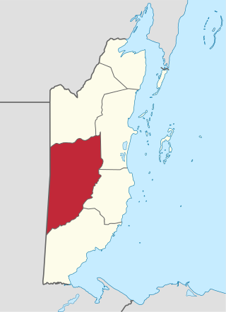
Cayo District is a district located in the west part of Belize. It is the most extensive, second-most populous and third-most densely populated of the six districts of Belize. The district's capital is the town of San Ignacio.
San Ignacio and Santa Elena are towns in western Belize. San Ignacio serves as the cultural-economic hub of Cayo District. It got its start from mahogany and chicle production during British colonisation. Over time it attracted people from the surrounding areas, which led to the diverse population of the town today. San Ignacio is the largest settlement in Cayo District and the second largest in the country, after Belize City.
Valley of Peace is a village in the Cayo District of Belize that was founded on March 12, 1982. In 2000 Valley of Peace had a population of 1,809 people. The population in 2007 grew to 2,108.
Roaring Creek is a small village in the Cayo District of Belize, just north-west of Belmopan. Its name is derived from the creek waterfalls which flow into the Belize River next to the Guanacaste Park area.

The Mopan River is a river in Central America spanning the Petén Department of Guatemala and the Cayo District of Belize. It merges with the Macal River at Branch Mouth, Belize, forming the Belize River, which ultimately discharges into the Caribbean Sea. The drainage area of the combined watershed is 9,434.2 km2 (3,642.6 sq mi). Tributaries of the Mopan include Chiquibul Branch, Ceiba Grande, Salisipuedes, and Delores.

Christianity is the dominant religion in Belize. The single largest denomination is the Catholic Church with about 40.1% of the population, a reduction from 49.6% of the population in 2000, 57.7% in 1991 and 61.9% in 1980, although absolute numbers have still risen. Other major groups include Pentecostal with 8.4% of the population up from 7.4% in 2000 and 6.3% in 1991, Seventh-day Adventists with 5.4% of the population up from 5.2% in 2000 and 4.1% in 1991. The following of the Anglican Church has been steadily declining, with only 4.7% of the population in 2010 compared to 6.95% in 1991. About 12,000 Mennonites live mostly in the rural districts of Cayo and Orange Walk. People who declared they belong to no religion make up 15.5% of the population in 2010, more than double their 2000 census numbers. 11.2% adhere to other religions which include the Maya religion, Afro-Caribbean religions, Mormons, Hindus, Buddhists, Muslims, Baháʼís, Rastafarians and others.
Armenia is a village in the Cayo District of Belize, along the nation's Hummingbird Highway south of the capitol, Belmopan.
Water resources management in Belize is carried out by the Water and Sewerage Authority (WASA) in most cases. One of the primary challenges the country is facing with regard to water resources management, however, is the lack of coordinated and comprehensive policies and institutions. Furthermore, there are various areas of water management that are not well addressed at all such as groundwater data and provision of supply. Data on irrigation and drainage is not adequately available either. Demand on water resources is growing as the population increases, new economic opportunities are created, and the agriculture sector expands. This increased demand is placing new threats on the quality and quantity of freshwater resources. Other constant challenge for management entities are the constant threat of floods from tropical storms and hurricanes. The Belize National Emergency Management Organization (NEMO) is charged with flood management as they occur but it is unclear what institution has responsibility for stormwater infrastructures.
Burrell Boom is on the Belize River twenty miles above Belize City, Belize. Tourists pass through this historic village on their way to the Community Baboon Sanctuary, where the population of black howler monkeys has grown to over 2,000.

Bullet Tree Falls is a village located along the Mopan River in Cayo District, Belize. It lies approximately five kilometers northwest of San Ignacio. According to the 2010 census, Bullet Tree Falls has a population of 2,124 people in 426 households. The population consists mainly of Spanish-speaking mestizos, along with a smaller number of Yucatec Maya and Creoles.

Pacbitun is a Maya archaeological site located near the town of San Ignacio, Belize, in the Cayo District of west central Belize. The modern Maya name given to the site means “stone set in earth”, likely a reference to multiple fragments of stone monuments. The site, at about 240 m above sea level, is one of the earliest known from the southern Maya Lowlands, and was inhabited for almost 2000 years, from ca. 900 BCE to 900 CE. Strategically, it straddles a territory of rolling, hilly terrain between the Mountain Pine Ridge and the tropical forest covered lowlands of the Upper Belize River Valley.
Camalote is a village located along the George Price Highway in Cayo District, Belize. It lies approximately five kilometers west of Belmopan.
Springfield is a Mennonite village in Cayo District, Belize, some 15 km south of the capital Belmopan.

Lower Dover is a Maya archaeological site in the Belize River Valley. It is located on the grounds of the Lower Dover Field Station & Jungle Lodge, in Unitedville, Cayo District, Belize. The site is bordered by the Belize River to the north, Upper Barton Creek to the west, Lower Barton Creek to the east, and the Western Highway to the south. Lower Dover is one of several Maya archaeological sites in the area; it is across the Belize River from Barton Ramie, 3 kilometers west of Blackman Eddy, and 6 kilometers east of Baking Pot.

Cotton Tree is a village in the Cayo District of central interior Belize. The village is situated 5km to the northeast of Belmopan along the Western Highway. The surrounding area is agricultural with the most frequent crops being citrus and banana. It is one of 192 municipalities administered at the village level in the country for census taking purposes.
