| Alternative names | Moreton Mill |
|---|---|
| Current status | Closed |
| Location | Nambour, Queensland Australia |
| Owner | Bundaberg Sugar Ltd |
| Further ownership |
|
| Coordinates | 26°37′39″S152°57′26″E / 26.6275°S 152.9572°E |
| Construction | |
| Built | 1897 |
| Demolished | 2006 |
Moreton Central Sugar Mill was a sugar milling facility in Nambour, Queensland, Australia owned by Bundaberg Sugar Ltd.
Sugar cane was first brought to Australia in 1788, but subsequent plantings at Sydney, Port Macquarie and Norfolk Island failed to be commercially viable. Captain Louis Hope grew a cane crop successfully in Queensland in 1862. By 1864 the first commercial sugar mill in Australia had been established by him at Ormiston and interest in growing sugar cane spread rapidly, encouraged by the Queensland Government. By 1867 an estimated 2000 acres were under cane in the Brisbane area and by the end of the decade, cane had also been successfully established further north at Maryborough, Mackay and Bundaberg, where the warmer climate proved more suitable.
William Clark had experimented with sugar cane growing at Bli Bli in the 1860s, but in 1869 a group of Quakers took up land near the junction of the Mooloolah River and Sippy Creek, planted sugar cane and erected a crushing mill. This project was abandoned after severe flooding in the 1870s, but cane was grown successfully in other parts of the district including Buderim, where in 1876 Joseph Chapman Dixon, one of the Mooloolah growers, established a mill in order to process his own cane and that of neighbouring farms.
In 1881 the Buderim Mountain Sugar Mill was established and also served many small farms, but both mills had failed by the end of the decade. In 1893, the Sugar Works Guarantee Act was passed. This provided capital for the erection of central sugar mills in districts with many small farms by offering loans to incorporated companies, so that growers could develop their own mills. The Moreton Central Sugar Mill Company was formed in December 1894. Land bounded by the North Coast railway line on the west and Gympie Road on the east was purchased for a mill site at the small settlement of Nambour. Erection of a mill by Caskie and Thompson began in late 1895.
In order for the mill to be successful, it was essential to establish an efficient means for bringing the harvested cane in from surrounding farms to be crushed. Tramway networks carrying wagons drawn by steam locomotives had been used effectively in other Queensland sugar districts since the 1880s, so possible routes for a tramway network were surveyed as part of the planning for the Moreton Mill. A two-foot (610mm) gauge was chosen for the sake of economy, speed not being an important factor in the running of the tramway, though the wagons were at first pulled by horses. In 1897 the first tramlines were constructed east to Perrin's Barn and west to the foot of the Perwillowen Range and the first harvest was crushed at the mill.
The Moreton Central Sugar Mill ended crushing operations in late 2003 and was demolished in 2006. Prior to the mill's closure, Finasucre [1] (Belgium) bought Bundaberg Sugar Ltd. [2]
Between 1980 and 2003 more than 1,000 hectares of cane land in Maroochy Shire were lost to urban development and other uses. This meant that some cane was being brought to the mill from 60 or 70 kilometres away. As it is important that cane is crushed soon after harvesting to maintain its sugar content, this had an adverse effect on the functioning of the mill. The price of sugar also fell and a crisis was reached in 2002. It was decided that Moreton Mill would close. Its last crush took place on 3 December 2003. The majority of the tramlines were removed by Bundaberg Sugar as part of an agreement with landowners from whom the tramline corridor was leased. The section of line covered by this entry represents its use as a transport system for both cane and passengers and as an unusual feature of the Nambour.
The former Moreton Mill Site was purchased by Coles who have developed a multi-storey shopping complex trading under the title 'Nambour Mill Village'. [3] [4]
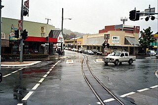
The main cane tramway is laid directly into the centre of the roadway and runs through the central business district of Nambour. It is of a 2-foot (610 mm) gauge and travels between the road reserve in front of the former mill site in Mill Street, across the Currie Street intersection and down Howard Street to the marshalling yards [5] where it continues to other parts of the region. After the mill's closure the majority of the rail network was removed and locomotives were auctioned [6] or donated to the Nambour & District Historical Museum Association. [7]
Steam locomotives were utilised at the mill until the 1980s but at the same time were also operating Diesel and V8 petrol locomotives. [7] The former Howard Street Marshalling Yards were purchased by Aldi Supermarkets who have developed an Aldi Supermarket on the location.
The mill's tramway network connected the many farms to the mill, ensuring quick transportation. The farms stretched from the Nambour region to areas near Coolum Beach, Valdora and Noosa. By 1967, when the Sunshine Coast was officially named, the mill's tramway was 70 miles long, as it required to receive the maximum amount of local sugar.

The Sunshine Coast is a peri-urban region in South East Queensland, Australia. In 1967, it was defined as "the area contained in the [former] Shires of Landsborough, Maroochy and Noosa, but excluding Bribie Island". Located 100 km (62 mi) north of the centre of Brisbane in South East Queensland, on the Coral Sea coastline, its urban area spans approximately 60 km (37 mi) of coastline and hinterland from Pelican Waters to Tewantin.

Nambour is a rural town and locality in the Sunshine Coast Region, Queensland, Australia. In the 2021 census, the locality of Nambour had a population of 12,145 people.
Buderim is a town in the Sunshine Coast Region, Queensland, Australia. It sits on a 180-metre (590 ft) mountain which overlooks the southern Sunshine Coast communities.

Yandina is a rural town and locality in the Sunshine Coast Region, Queensland, Australia. In the 2021 census, the locality of Yandina had a population of 3,073 people.

The North Coast railway line (NCL) is a 1,681-kilometre (1,045 mi) 1067 mm gauge railway line in Queensland, Australia. It commences at Roma Street station, Brisbane, and largely parallels the Queensland coast to Cairns in Far North Queensland. The line is electrified between Brisbane and Rockhampton. Along the way, the 1680 km railway passes through the numerous towns and cities of eastern Queensland including Nambour, Bundaberg, Gladstone, Rockhampton, Mackay and Townsville. The line though the centre of Rockhampton runs down the middle of Denison Street.

The Big Pineapple is a heritage-listed tourist attraction and big thing at Nambour Connection Road, Woombye, Sunshine Coast Region, Queensland, Australia. It was designed by Peddle Thorp and Harvey, Paul Luff, and Gary Smallcombe and Associates. It is also known as Sunshine Plantation. It was added to the Queensland Heritage Register on 6 March 2009.

The rail network in Queensland, Australia, was the first in the world to adopt 1,067 mm narrow gauge for a main line, and, in 2013, was claimed to the second largest narrow gauge network in the world, consists of:
Rosemount is a rural locality in the Sunshine Coast Region, Queensland, Australia. In the 2021 census, Rosemount had a population of 1,851 people.
Image Flat is a rural locality in the Sunshine Coast Region, Queensland, Australia. In the 2021 census, Image Flat had a population of 457 people.

The Sunshine Coast Region is a local government area located in the Sunshine Coast region of South East Queensland, Australia, from which it takes its name.

Oaklands Sugar Mill is a heritage-listed remains of a former sugar cane mill at 68 Captain Whish Avenue, Morayfield, City of Moreton Bay, Queensland, Australia. It was built in 1865. It is also known as Whish's Sugar Mill Remnants. It was added to the Queensland Heritage Register on 18 September 2009.
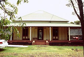
Canambie Homestead is a heritage-listed plantation at 12 Dixon Road, Buderim, Sunshine Coast Region, Queensland, Australia. It was built c. 1883. It is also known as Joseph Dixon's House. It was added to the Queensland Heritage Register on 22 October 2000.

The Palmwoods-Buderim Tramway is a heritage-listed former tramway at Telco Road, Buderim, Sunshine Coast Region, Queensland, Australia. It was built from 1914 and operated until 1935. It was added to the Queensland Heritage Register on 28 July 2000.
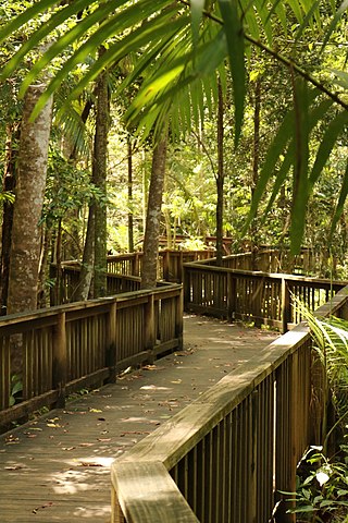
Dunethin Rock is a heritage-listed park at Dunethin Rock Road, Maroochy River, Sunshine Coast Region, Queensland, Australia. It was added to the Queensland Heritage Register on 5 February 2009.
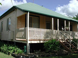
Moreton Central Sugar Mill Worker's Housing is a heritage-listed group of houses at 17 & 19 Mill Street, and 14 & 16 Bury Street, Nambour, Sunshine Coast Region, Queensland, Australia. It was added to the Queensland Heritage Register on 16 May 2008.
Moreton Central Sugar Mill Cane Tramway is a heritage-listed tramway at Mill Street, Currie Street, and Howard Street, in Nambour, Sunshine Coast Region, Queensland, Australia. It was built c. 1897. It was added to the Queensland Heritage Register on 7 February 2005.
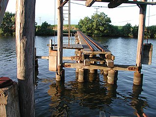
The Tramway Lift Bridge over Maroochy River is a heritage-listed railway bridge at Store Road, Nambour, Sunshine Coast Region, Queensland, Australia. It was built in 1921. It was added to the Queensland Heritage Register on 7 February 2005.

Fairymead Sugar Plantation was a sugar plantation in Fairymead, Bundaberg Region, Queensland, Australia. It was established by Ernest Young together with his father Henry and brothers Arthur, and Horace. It was one of Bundaberg's earliest independent sugar plantations and had one of its earliest sugar mills.
The 1920 North Coast Rugby League season was the first season of rugby league football in the area that is now the Sunshine Coast, Queensland, all of the clubs having changed over from rugby union in March 1920.