Moringen

Last updated
Moringen
Moringen-Wappen.png
Location of Moringen within Northeim district
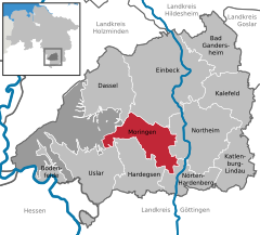
Moringen in NOM.svggemeindefreies Gebiet Solling
Germany adm location map.svg
Red pog.svg
Moringen
Lower Saxony location map.svg
Red pog.svg
Moringen
Coordinates: 51°42′N9°52′E / 51.700°N 9.867°E / 51.700; 9.867 Coordinates: 51°42′N9°52′E / 51.700°N 9.867°E / 51.700; 9.867
Country Germany
State Lower Saxony
District Northeim
Subdivisions9 districts
Government
   Mayor (202126) Heike Müller-Otte [1] (Ind.)
Area
  Total82.25 km2 (31.76 sq mi)
Highest elevation
457 m (1,499 ft)
Lowest elevation
137 m (449 ft)
Population
 (2020-12-31) [2]
  Total6,941
  Density84/km2 (220/sq mi)
Time zone UTC+01:00 (CET)
  Summer (DST) UTC+02:00 (CEST)
Postal codes
37186
Dialling codes 05554
Vehicle registration NOM
Website www.moringen.de

Moringen is a town in the district Northeim, in the southern part of Lower Saxony, Germany. The town consists of the center Moringen and eight surrounding villages, Fredelsloh being one of them.

Contents

History

The town and its villages were founded over a thousand years ago. It is the seat of a psychiatric hospital, founded in late 19th century. During WWII the hospital was emptied and used by the Nazis as the Moringen concentration camp. Today it is again a psychiatric hospital.

Economy

Among the larger firms operating in the community is Piller, a maker of industrial fans. The Northeim district's major waste Landfill is in Moringen.

Museum

Literature

by Gabriele Herz (Author), Jane Caplan (Editor), Hildegard Herz (Translator), Howard Hartig (Translator). Berghahn Books (15 Nov 2005). ISBN   1-84545-077-9; ISBN   978-1-84545-077-9.

See also

Related Research Articles

Celle is a district (Landkreis) in Lower Saxony, Germany. It is bounded by the districts of Uelzen, Gifhorn, Hanover and Heidekreis.

Rinteln Town in Lower Saxony, Germany

Rinteln is a small town in Lower Saxony, Germany. It is located on the banks of the Weser river above the Porta Westfalica. The town of Rinteln is in the broad valley between the hills of the Weserbergland and the North Lippe Bergland. In relation to some well known places, it is 60 kilometers west of Hanover, and just 20 kilometers from Hamelin of Pied Piper fame. Its population is about 28,500.

Holzminden is a district in Lower Saxony, Germany, with the town of Holzminden as its administrative capital. It is bounded by the districts of Hamelin-Pyrmont, Hildesheim and Northeim, and by the state of North Rhine-Westphalia.

Northeim (district) District in Lower Saxony, Germany

Northeim is a district in Lower Saxony, Germany. It is bounded by the districts of Holzminden, Hildesheim, Goslar and Göttingen, and the state of Hesse.

Bad Gandersheim Town in Lower Saxony, Germany

Bad Gandersheim is a town in southern Lower Saxony, Germany, located in the district of Northeim. As of December 2020, it had a population of 9,492.

Cremlingen Municipality in Lower Saxony, Germany

Cremlingen is a municipality in the district of Wolfenbüttel, Lower Saxony, Germany. It borders Lehre, Königslutter, Sickte, and Braunschweig. Parts of it are adjacent to the Elm hills.

Northeim Town in Lower Saxony, Germany

Northeim is a town in Lower Saxony, Germany, seat of the district of Northeim, with, in 2011, a population of 29,000. It lies on the German Half-Timbered House Road.

Artern Town in Thuringia, Germany

Artern is a town in the Kyffhäuserkreis district, Thuringia, Germany. The former municipalities Heygendorf and Voigtstedt were merged into Artern in January 2019.

Bad Zwischenahn Municipality in Lower Saxony, Germany

Bad Zwischenahn is a town and a municipality in the low-lying Ammerland district, in Lower Saxony, Germany. It is on Zwischenahner Meer, approximately 15 km northwest of Oldenburg and about 70 km south of the North Sea coast.

Hardegsen Town in Lower Saxony, Germany

Hardegsen is a town in the district of Northeim, in Lower Saxony, Germany. It is situated approximately 15 km southwest of Northeim, and 15 km northwest of Göttingen.

Bodenfelde Municipality in Lower Saxony, Germany

Bodenfelde is a municipality in the district of Northeim, in Lower Saxony, Germany. It is situated on the right bank of the Weser, approx. 35 km north of Kassel, and 30 km northwest of Göttingen at the southwest border of the Solling-Vogler Nature Park.

Kalefeld Municipality in Lower Saxony, Germany

Kalefeld is a municipality in the district of Northeim, in Lower Saxony, Germany. It is situated approximately 10 km north of Northeim. It comprises the villages of Dögerode, Eboldshausen, Echte, Kalefeld, Oldenrode, Oldershausen, Sebexen, Westerhof, Wiershausen, and Willershausen.

Katlenburg-Lindau Municipality in Lower Saxony, Germany

Katlenburg-Lindau is a municipality in the Landkreis (district) of Northeim in Lower Saxony, Germany. It is situated approximately 10 km southeast of Northeim, and 20 km northeast of Göttingen. Katlenburg-Lindau was formed on 1 March 1974 from the formerly independent communities of Katlenburg-Duhm, Gillersheim, Berka, Elvershausen, Wachenhausen, Suterode and Lindau. With the exception of Lindau, which had belonged Landkreis Duderstadt, these communities were part of Landkreis Northeim. The Max Planck Institute for Solar System Research of the Max Planck Society was located in Lindau from 1946 to 2014, when it was moved to Göttingen. Until June 2004 the MPI was known as "Max-Planck-Institut für Aeronomie".

Nörten-Hardenberg Municipality in Lower Saxony, Germany

Nörten-Hardenberg is a municipality in the district of Northeim, in Lower Saxony, Germany.

Vechelde Municipality in Lower Saxony, Germany

Vechelde is a municipality in the district of Peine, in Lower Saxony, Germany. It is situated approximately 12 km southeast of Peine, and 10 km west of Braunschweig.

Pocking Town in Bavaria, Germany

Pocking is a town in the district of Passau, in Lower Bavaria, Germany. It is situated about 30 km south-west of Passau, close to the Austrian border.

Schwarzenbach an der Saale Town in Bavaria, Germany

Schwarzenbach an der Saale is a town in the district of Hof, in Bavaria, Germany. It is situated on the river Saale, 11 km south of Hof. Within the town is the Gedenkstätte Langer Gang, a memorial to the Nazi victims of the Helmbrechts concentration camp, which was near Schwarzenbach an der Saale, and particularly of the victims of the death march from Helmbrechts concentration camp to Volary.

Wulften am Harz Municipality in Lower Saxony, Germany

Wulften am Harz is a municipality in Lower Saxony, Germany, near the towns of Northeim and Osterode am Harz.

Three concentration camps operated in succession in Moringen, Lower Saxony, from April 1933 to April 1945. KZ Moringen, established in the centre of the town on site of former 19th century workhouses, originally housed mostly male political inmates. In November 1933 - March 1938 Moringen housed a women's concentration camp; in June 1940 - April 1945 a juvenile prison. A total of 4,300 people were prisoners of Moringen; an estimated ten percent of them died in the camp.

Jane Caplan

Jane Caplan is an academic and historian specialising in Nazi Germany and the history of the documentation of individual identity. She is currently Visiting Professor at Birkbeck, University of London, Visiting Professor of History at Gresham College and Emeritus Fellow at St. Antony's College, University of Oxford.

References