Bad Gandersheim

Last updated
Bad Gandersheim
Bad-gandersheim-2a.jpg
Wappen Bad Gandersheim.png
Location of Bad Gandersheim within Northeim district
Bad Gandersheim in NOM.svggemeindefreies Gebiet Solling
Germany adm location map.svg
Red pog.svg
Bad Gandersheim
Lower Saxony location map.svg
Red pog.svg
Bad Gandersheim
Coordinates: 51°52′19″N10°1′31″E / 51.87194°N 10.02528°E / 51.87194; 10.02528
Country Germany
State Lower Saxony
District Northeim
Government
   Mayor (202126) Franziska Schwarz [1] (SPD)
Area
  Total9.049 km2 (3.494 sq mi)
Elevation
143 m (469 ft)
Population
 (2021-12-31) [2]
  Total9,476
  Density1,000/km2 (2,700/sq mi)
Time zone UTC+01:00 (CET)
  Summer (DST) UTC+02:00 (CEST)
Postal codes
37575–37581
Dialling codes 05382
Vehicle registration NOM, EIN, GAN
Website www.bad-gandersheim.de
Marketplace. Left: Weisses Ross Hotel, centre: Zur Ecke, right: Bracken Bad Gandersheim Marktplatz 284-85-d.jpg
Marketplace. Left: Weißes Roß Hotel, centre: Zur Ecke, right: Bracken
Marketplace Bad-gandersheim-1.jpg
Marketplace
Airfield Tower des Flugplatzes Bad Gandersheim.jpg
Airfield

Bad Gandersheim (Eastphalian: Ganderssen) is a town in southern Lower Saxony, Germany, located in the district of Northeim. As of December 2020, it had a population of 9,492.

Contents

Bad Gandersheim has many half-timbered houses and is located on the German Timber-Frame Road (German : Deutsche Fachwerkstraße). The town contains an airport as well.

Geography

The town of Bad Gandersheim lies between the Leine Uplands, Weser Uplands, and Harz Foreland in the valley of the Gande River, into which its tributary, the Eterna, empties within the town's territory. To the north lies the Heber Ridge. The borough is predominantly hilly. The Harz Mountains begin about 10 kilometres (6.2 miles) east of the town, and 5 kilometres (3.1 miles) to the west is the Leine Graben (German : Leinegraben).

Borough divisions

The borough of Bad Gandersheim consists of the following subdivisions based on the surrounding villages:

  • Ackenhausen
  • Altgandersheim
  • Clus
  • Dankelsheim
  • Dannhausen
  • Ellierode
  • Gehrenrode
  • Gremsheim
  • Hachenhausen
  • Harriehausen
  • Heckenbeck
  • Helmscherode
  • Seboldshausen
  • Wolperode
  • Wrescherode

History

The town dates back to 852, when Gandersheim Abbey, a house of secular canonesses, was created in nearby Brunshausen by Liudolf, Duke of Saxony and his wife Oda. The first abbey church (German : Stiftskirche) in the town proper was begun in 856. In 990 the abbey received the market and tax rights. During the 10th century, Gandersheim was one of the most important towns of Saxony; the first German poet Hrosvit (Roswitha) lived and worked here until 973. In 1159 Gandersheim was first mentioned as a town.

When a mineral spring was discovered in 1240, Pope Gregory IX initiated the erection of the Holy Spirit hospital. Around 1330, the Dukes of Brunswick built a castle as a secular counterbalance to the abbey church. This building serves today as the magistrates' court and youth correctional facility.

In the late 19th century, the town began to become known for the curative powers of its mineral springs, and in 1932 Gandersheim received the official right to call itself a spa town, thus Bad Gandersheim, on account of these springs.

In the summer of 1926 there was a three-day "Roswitha Memorial Celebration in 1000-year old Gandersheim". This was the first time the medieval author was used as a symbolic figure for the town. Similar celebrations took place in 1930 and 1933; these had clear national-socialist themes: "German Culture" versus "Jewish-Communist Decadence."

During World War 2, from October 1944 to April 1945, the town was the site of a subcamp of the Buchenwald Concentration Camp that produced aircraft parts.

In 1952, the town celebrated the 1100-year jubilee of the founding of the monastery by Liudolf. A history play, The Song of Gandersheim, was presented in the market square. This was the unofficial prelude to the summer festival Gandersheimer Domfestspiele , which has been presented yearly on the plaza in front of the abbey church since 1959. Since this time, it has established itself as Lower Saxony's largest professional summer theatre festival. In 2006, its four major productions were attended by approximately 55,000 theatre visitors.

Mayors

Twin towns

Bad Gandersheim is twinned with:

Hrotsvitha, 1501 Roswitha Duerer.jpg
Hrotsvitha, 1501

Notable residents

Related Research Articles

Hanover Region is a district in Lower Saxony, Germany. It is bounded by the districts of Heidekreis, Celle, Gifhorn, Peine, Hildesheim, Hamelin-Pyrmont, Schaumburg and Nienburg.

<span class="mw-page-title-main">Alfeld</span> Town in Lower Saxony, Germany

Alfeld is a town in the state of Lower Saxony, Germany. Located on the Leine river, it is the second biggest city in the district of Hildesheim in southern Lower Saxony and part of the Metropolitan region Hannover-Braunschweig-Göttingen-Wolfsburg. Alfeld is a member of the Leinebergland region and on the German Timber-Frame Road. With the Fagus Factory, Alfeld became a UNESCO World Heritage Site in 2011.

<span class="mw-page-title-main">Northeim (district)</span> District in Lower Saxony, Germany

Northeim is a district in Lower Saxony, Germany. It is bounded by the districts of Holzminden, Hildesheim, Goslar and Göttingen, and the state of Hesse.

<span class="mw-page-title-main">Goslar</span> Place in Lower Saxony, Germany

Goslar is a historic town in Lower Saxony, Germany. It is the administrative centre of the district of Goslar and is located on the northwestern slopes of the Harz mountain range. The Old Town of Goslar and the Mines of Rammelsberg are UNESCO World Heritage Sites for their millennium-long testimony to the history of ore mining and their political importance for the Holy Roman Empire and Hanseatic League. Each year Goslar awards the Kaiserring to an international artist, called the "Nobel Prize" of the art world.

<span class="mw-page-title-main">Braunlage</span> Place in Lower Saxony, Germany

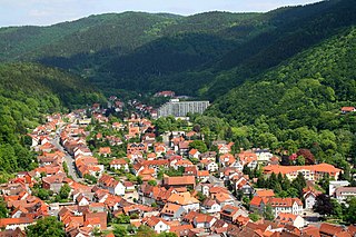
Braunlage is a town and health resort in the Goslar district of Lower Saxony in Germany. Situated within the Harz mountain range, south of the Brocken massif, Braunlage's main business is tourism, particularly skiing. Nearby ski resorts include the Sonnenberg and the slopes on the Wurmberg.

<span class="mw-page-title-main">Schwarmstedt</span> Municipality in Lower Saxony, Germany

Schwarmstedt is a municipality in the Heidekreis in Lower Saxony, Germany. It is situated near the confluence of the rivers Aller and Leine, approx. 20 km south of Bad Fallingbostel, and 30 km east of Nienburg. Further districts of the municipality are

<span class="mw-page-title-main">Liudolf, Duke of Saxony</span> Duke of Saxony

Liudolf was a Carolingian office bearer and count in the Duchy of Saxony from about 844. The ruling Liudolfing house, also known as the Ottonian dynasty, is named after him; he is its oldest verified member.

<span class="mw-page-title-main">Bad Harzburg</span> Place in Lower Saxony, Germany

Bad Harzburg is a spa town in central Germany, in the Goslar district of Lower Saxony. It lies on the northern edge of the Harz mountains and is a recognised saltwater spa and climatic health resort.

<span class="mw-page-title-main">Herzberg am Harz</span> Town in Lower Saxony, Germany

Herzberg am Harz is a town in the Göttingen district of Lower Saxony, Germany.

<span class="mw-page-title-main">Langelsheim</span> Place in Lower Saxony, Germany

Langelsheim is a town in the district of Goslar in Lower Saxony, Germany.

<span class="mw-page-title-main">Seesen</span> Place in Lower Saxony, Germany

Seesen is a town and municipality in the district of Goslar, in Lower Saxony, Germany. It is situated on the northwestern edge of the Harz mountain range, approx. 20 km (12 mi) west of Goslar.

<span class="mw-page-title-main">Liebenburg</span> Place in Lower Saxony, Germany

Liebenburg is a municipality in the district of Goslar, in Lower Saxony, Germany.

<span class="mw-page-title-main">Nörten-Hardenberg</span> Municipality in Lower Saxony, Germany

Nörten-Hardenberg is a municipality in the district of Northeim, in Lower Saxony, Germany.

<span class="mw-page-title-main">Bad Lauterberg</span> Place in Lower Saxony, Germany

Bad Lauterberg is a town in the district of Göttingen, in Lower Saxony, Germany. It is situated in the southern Harz, approx. 15 km southwest of Braunlage, and 20 km southeast of Osterode am Harz.

<span class="mw-page-title-main">Bad Sachsa</span> Place in Lower Saxony, Germany

Bad Sachsa is a town in the district of Göttingen, in Lower Saxony, Germany. The town was one of the few municipalities in West Germany that imported electric power from former East Germany. This was done via Neuhof Substation.

<span class="mw-page-title-main">Bad Grund</span> Place in Lower Saxony, Germany

Bad Grund (Harz) is a town in the district of Göttingen, in Lower Saxony, Germany. It is situated in the western Harz, approx. 7 km west of Clausthal-Zellerfeld, and 10 km north of Osterode am Harz.

<span class="mw-page-title-main">Gandersheim Abbey</span>

Gandersheim Abbey is a former house of secular canonesses (Frauenstift) in the present town of Bad Gandersheim in Lower Saxony, Germany. It was founded in 852 by Duke Liudolf of Saxony, progenitor of the Liudolfing or Ottonian dynasty, whose rich endowments ensured its stability and prosperity.

<span class="mw-page-title-main">Leine Uplands</span>

The Leine Uplands is a region in Germany's Central Uplands which forms a part of the Lower Saxon Hills and lies along the River Leine between Göttingen and Hanover. It borders on the Weser Uplands in the west, the Innerste Uplands in the northeast, the Harz in the east and Untereichsfeld in the southeast.

<span class="mw-page-title-main">Heber (hills)</span> Hill range in Germany

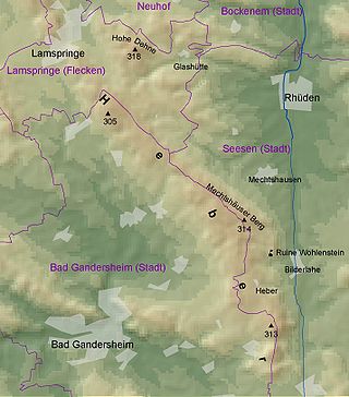
The Heber is a hogback ridge, relatively small in area and up to 313.5 metres high, in the Lower Saxon Hills within the districts of Goslar, Northeim and Hildesheim in the German state of Lower Saxony.

<span class="mw-page-title-main">Schladen-Werla</span> Municipality in Lower Saxony, Germany

Schladen-Werla is a municipality in the district of Wolfenbüttel, in Lower Saxony, Germany. It was formed on 1 November 2013, when the municipalities of the former Samtgemeinde Schladen: Gielde, the town of Hornburg, Schladen proper, and Werlaburgdorf were merged.

References

  1. "Stichwahlen zu Direktwahlen in Niedersachsen vom 26. September 2021" (PDF). Landesamt für Statistik Niedersachsen. 13 October 2021.
  2. "LSN-Online Regionaldatenbank, Tabelle A100001G: Fortschreibung des Bevölkerungsstandes, Stand 31. Dezember 2021" (in German). Landesamt für Statistik Niedersachsen.