
Idaho is a state in the Pacific Northwest region of the Western United States. To the north, it shares a small portion of the Canada–United States border with the province of British Columbia. It borders the states of Montana and Wyoming to the east, Nevada and Utah to the south, and Washington and Oregon to the west. The state's capital and largest city is Boise. With an area of 83,570 square miles (216,400 km2), Idaho is the 14th largest state by land area, but with a population of approximately 1.8 million, it ranks as the 13th least populous and the 7th least densely populated of the 50 U.S. states.

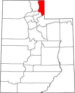
Cache County is a county located in the Wasatch Front region of Utah. As of the 2020 United States Census the population was 133,154. Its county seat and largest city is Logan. Cache County is included in Logan metropolitan area.

Grand County is a county on the east central edge of the U.S. state of Utah, United States. As of the 2010 United States Census, the population was 9,225. Its county seat and largest city is Moab.
Rich County is a county in the U.S. state of Utah. As of the 2010 United States Census, the population was 2,264, making it the third-least populous county in Utah. Its county seat is Randolph, and the largest town is Garden City. The county was created in 1864. It was named for an early LDS apostle, Charles C. Rich.

Sanpete County is a county in the U.S. state of Utah. As of the 2010 United States Census, the population was 27,822. Its county seat is Manti, and its largest city is Ephraim. The county was created in 1850.

Tooele County is a county in the U.S. state of Utah. As of the 2010 United States Census, the population was 58,218. Its county seat and largest city is Tooele. The county was created in 1850 and organized the following year.

Wasatch County is a county in the U.S. state of Utah. As of the 2010 United States Census, the population was 23,530. Its county seat and largest city is Heber City. The county was named for a Ute Indian word meaning mountain pass or low place in the high mountains.
Cassia County is a county in the U.S. state of Idaho. As of the 2020 Census the county had a population of 24,655. The county seat and largest city is Burley. Cassia County is included in the Burley, ID Micropolitan Statistical Area.

American Falls is a city in and the county seat of Power County, Idaho. The population was 4,457 at the time of the 2010 census.

Boise National Forest is a National Forest covering 2,203,703 acres (8,918.07 km2) of the U.S. state of Idaho. Created on July 1, 1908, from part of Sawtooth National Forest, it is managed by the U.S. Forest Service as five units: the Cascade, Emmett, Idaho City, Lowman, and Mountain Home ranger districts.

Owyhee Reservoir or Owyhee Lake is a reservoir on the Owyhee River in Malheur County, Oregon, United States. Located in far Eastern Oregon near the Idaho border, the reservoir is Oregon's longest at 52 miles (84 km). The 13,900-acre (56 km2) lake is home to several species of fish, including crappie, rainbow trout, largemouth bass, smallmouth bass, yellow perch, and brown bullhead. An artificial lake, it was created in 1932 with the completion of the Owyhee Dam. The lake supplies water for irrigation for 1,800 farms covering 118,000 acres of land in Eastern Oregon and Southwestern Idaho. Seasonal Lake Owyhee State Park is located on the northeast shore and includes a boat ramp.

Salmon Falls Creek is a tributary of the Snake River, flowing from northern Nevada into Idaho in the United States. Formed in high mountains at the northern edge of the Great Basin, Salmon Falls Creek flows northwards 121 miles (195 km), draining an arid and mountainous basin of 2,103 square miles (5,450 km2). The Salmon Falls Creek valley served as a trade route between the Native American groups of the Snake River Plain and Great Basin. Today, most of its water is used for irrigation.

Cecil D. Andrus Wildlife Management Area (WMA) is a 23,908 acres (96.75 km2) Idaho wildlife management area in Washington County, 18 miles (29 km) from Cambridge, Idaho. The WMA was formed in 1993, when the Mellon Foundation purchased the Hillman Ranch and deeded it to the Idaho Department of Fish and Game for wildlife conservation. The WMA now manages additional lands as well, primarily from the Idaho Department of Lands, but also from Payette National Forest and the Bureau of Land Management. It is named for Cecil D. Andrus, a former U.S. Secretary of the Interior who also served four terms as Governor of Idaho.
C.J. Strike Wildlife Management Area at 10,664 acres (43.16 km2) is an Idaho wildlife management area in Elmore and Owyhee counties southwest of Mountain Home. The Idaho Department of Fish and Game manages Idaho Power Company, U.S. Fish and Wildlife Service, and Bureau of Land Management lands surrounding C. J. Strike Reservoir on the Snake and Bruneau rivers. In 2005, Idaho Power assumed management of the 3,000 acres (1,200 ha) it owns near the C. J. Strike Dam.
Smoky Mountain, at 7,579 feet (2,310 m) above sea level is a peak in the Albion Mountains of Idaho. The peak is located in Cassia County about 0.35 mi (0.56 km) east of the border of City of Rocks National Reserve on land managed by the Bureau of Land Management. It is 4.7 mi (7.6 km) north of the Nevada border.
Magic Reservoir is a reservoir on the Big Wood River on the border of Blaine and Camas counties, Idaho. However, most of the reservoir is located in Blaine County. The reservoir and surrounding Bureau of Land Management land offers opportunities for boating, fishing, camping, and hunting, among other activities. The reservoir is impounded by Magic Dam, which was built in 1910.

Mackay Reservoir is a reservoir on the Big Lost River in Custer County, Idaho, United States.

Willow Creek is a 84-mile (135 km) long tributary of the Snake River in the U.S. state of Idaho. Beginning at an elevation of 6,568 feet (2,002 m) east of the Blackfoot Mountains in southeastern Bingham County, it flows generally north into Bonneville County and past Bone. South of the town of Ririe, the creek is impounded by Ririe Dam, forming Ririe Reservoir. It then turns southwest, passing between Iona and Ucon, before bifurcating into two distributaries, North Fork Willow Creek and South Fork Willow Creek, at an elevation of 4,777 feet (1,456 m). Both forks reach the Snake River north of Idaho Falls.

Battle Creek is a 67-mile (110 km) long tributary of the Owyhee River. Beginning at an elevation of 6,704 feet (2,043 m) in central Owyhee County, Idaho, it flows generally south through the Owyhee Desert to its mouth west of Riddle, at an elevation of 4,636 feet (1,413 m). In 2009, 23.4 miles (37.7 km) of the creek were designated as wild by the Omnibus Public Land Management Act, which also created the Owyhee River Wilderness.

Gerber Reservoir is an irrigation impoundment created by Gerber Dam. It is located in southern Klamath County, Oregon, United States. The reservoir covers 3,815 acres (1,544 ha). The dam and reservoir are named in honor of Louis C. Gerber, an early pioneer who owned much of the land flooded by the reservoir. Today, the reservoir and surrounding property is owned by the United States Government. It is administered by the Bureau of Reclamation and the Bureau of Land Management. Gerber Reservoir is a popular outdoor recreation site with two campgrounds along its west shore.

