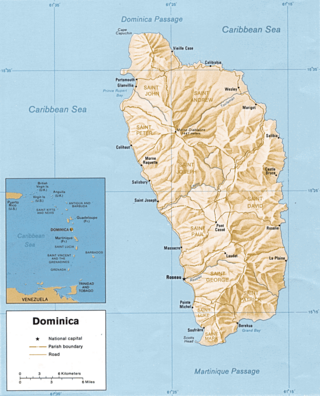
Dominica is an island in the Caribbean Sea, located about halfway between the French islands of Guadeloupe and Martinique. Its coordinates are 15 25 N, 61 20 W. It is known as "The Nature Island of the Caribbean" due to its spectacular, lush, and varied flora and fauna, which is protected by an extensive natural park system. It is the fourth largest island in the Eastern Caribbean with a population of people mainly of African descent.

Roseau is the capital and largest city of Dominica, with a population of 16,571 as of 2023. It is a small and compact urban settlement, in the Saint George parish and surrounded by the Caribbean Sea, the Roseau River and Morne Bruce. Built on the site of the ancient Island Carib village of Sairi, it is the oldest and most important urban settlement on the island of Dominica.

Iceland experiences frequent volcanic activity, due to its location both on the Mid-Atlantic Ridge, a divergent tectonic plate boundary, and over a hot spot. Nearly thirty volcanoes are known to have erupted in the Holocene epoch; these include Eldgjá, source of the largest lava eruption in human history.

Morne Diablotins is the highest mountain in Dominica, an island-nation in the Caribbean Lesser Antilles. It is the second highest mountain in the Lesser Antilles, after La Grande Soufrière in Guadeloupe. Morne Diablotins is located in the northern interior of the island, about 24 kilometres (15 mi) north of Dominica's capital Roseau and about 10 kilometres (6.2 mi) southeast of Portsmouth, the island's second-largest town. It is located within Morne Diablotin National Park.

The Carbet Mountains are a massif of volcanic origin on the Caribbean island of Martinique.

Morne Trois Pitons National Park is a national park in Dominica established in July 1975, the first to be legally established in the country. It became a World Heritage Site in 1997. The park is named after its highest mountain, Morne Trois Pitons, meaning mountain of three peaks. The park is an area of significant volcanic activity. Features within the park include the Valley of Desolation, a region of boiling mud ponds and small geysers; the Boiling Lake; Titou Gorge; and Emerald Pool. The mountain is the second-highest peak in Dominica, being exceeded only by Morne Diablotins.

A complex volcano, also called a compound volcano or a volcanic complex, is a mixed landform consisting of related volcanic centers and their associated lava flows and pyroclastic rock. They may form due to changes in eruptive habit or in the location of the principal vent area on a particular volcano. Stratovolcanoes can also form a large caldera that gets filled in by a lava dome, or else multiple small cinder cones, lava domes and craters may develop on the caldera's rim.

The Alaska Volcano Observatory (AVO) is a joint program of the United States Geological Survey (USGS), the Geophysical Institute of the University of Alaska Fairbanks (UAFGI), and the State of Alaska Division of Geological and Geophysical Surveys (ADGGS). AVO was formed in 1988, and uses federal, state, and university resources to monitor and study Alaska's volcanology, hazardous volcanoes, to predict and record eruptive activity, and to mitigate volcanic hazards to life and property. The Observatory website allows users to monitor active volcanoes, with seismographs and webcameras that update regularly. AVO now monitors more than 20 volcanoes in Cook Inlet, which is close to Alaskan population centers, and the Aleutian Arc due to the hazard that plumes of ash pose to aviation.
Grand Bay, known officially as Berekua or Berricoa, is a village in the south of Dominica. It has a population of 2,288 as of 2010, and is the largest settlement in St. Patrick Parish.
The Rosalie River is a river in Dominica. It rises on the eastern slopes of Morne Trois Pitons, flowing east to reach the Atlantic Ocean on the country's eastern coast, close to the town of Rosalie.
Morne Watt or Watt Mountain is a mountain consisting of one or more stratovolcanoes at the south end of Dominica in the eastern Caribbean Sea. With an elevation of 1,224 m (4,016 ft), it is the third highest mountain in Dominica after Morne Diablotins and Morne Trois Pitons. The mountain is home to the Boiling Lake and Valley of Desolation thermal areas, both of which are the best-known volcanic features in Dominica and major tourist attractions in Morne Trois Pitons National Park.
Pont Cassé is situated in the Saint Paul Parish in Dominica. It is located almost in the middle of Dominica, close to Belles Village northeast of the national capital, Roseau, and close to Morne Trois Pitons, the mountain which dominates the southern center of the country. As of 2006 it has a population of 100.
Morne Diablotin National Park is a national park in the northern mountain ranges of Dominica, an island nation in the Caribbean. The park comprises 3,335.3 hectares, amounting to 4.4% of the nation's area. It was established in January 2000, primarily to protect the habitat of the endangered sisserou parrot, an endemic bird species that is a national symbol of Dominica.
The River Bibiay is a river on the Caribbean island of Dominica.
Coulibistrie is a village on the west coast of Dominica, in the northwest corner of Saint Joseph Parish. It is between the villages of Colihaut to the north and Morne Rachette to the south. It extends inland from the coast within a deep valley, along both banks of the Coulibistrie River. The village is primarily residential with few businesses. Many of the houses are built directly atop or adjoining the numerous large boulders that litter the valley along its base.

Morne Rachette or Morne Raquette is a village on the west coast of Dominica, in the northwest corner of Saint Joseph Parish. It is located on the slopes of Morne Jalousie, above Coulibistrie to its immediate north and Batalie Bay. The village of Salisbury is south of Morne Rachette.

Morne aux Diables, also known as Devil's Peak, is a volcano on the island of Dominica and the volcanic formation is the northernmost peak on the island. The volcano is considered dormant, with no unusual volcanic activity reported aside from a swarm of small earthquakes detected in 2009–2010. Sulfur springs are present near the volcano.
